Posts Tagged ‘flattop’

Chaos Canyon Loop

May 14, 2011

May 14, 2011

The weather forecast was iffy for snow climbing…rain/snow after noon with higher temps.  We chose Flattop Mountain to give ourselves some options for choosing a descent after we see the conditions.  My guess was for Brian to drop down from the Flattop summit toward Notchtop via the Ptarmigan Glacier into Odessa Gorge and then circle back to Bear Lake via Lake Helene trail to Fern Lake trail to the bottom portion of Flattop Mountain trail. I liked having the option of simply returning via the Flattop trail.   Of course, my personal decision would be based on how I felt, the weather conditions, and the condition of the snow.

Brian picked me up at 5:30am and we headed up to Estes Park…for the 3rd weekend in a row. As we drove up, a solid wall of dark clouds blocked our view of the mountains….and even extended down to the tops of the foothills.  It was not going to be a nice day. But that was okay; I came for the exercise.

Flattop seen from Hallett. The trail approached from right to left.

The closer to RMNP and the higher we got, the darker the sky became; at the same time, we could tell the temperature was unusually warm.

Hello Spring.

Eventually, we got high enough to reach the cloud bank; we were driving inside a cloud. As we neared the Bear Lake parking lot in RMNP, we could see, to our surprise, that there were blue skies above the cloud bank. Suddenly we realized that we were going to get a lot of sun, at least until the after noon weather arrived.

As we pulled into the parking lot, Hallett Peak looked as beautiful as I have ever seen it.  And, once out of Brian’s truck, we could tell there was not a bit of wind for the first time in the 2011 season.

The plan for the ascent was to skirt Bear Lake (9450′) which sits at the mouth of Tyndall Gorge, taking the Flattop Mountain Trail for 4.4 miles to the top of Flattop Mountain.  The trail ascends the long north slope of Flattop that rises between Tyndall and Odessa Gorge.

We started up around Bear Lake at 7am…the snow was perfectly frozen hard, somehow.  My snowshoes were needed to grip the trail, not float on the snow. We made great time. I felt good enough that I took the lead and kept up a fast pace all the way to tree line without a break.  It was hot as Summer. At tree line, we stopped to put on sunscreen and admire the solid bank of cloud cover below us.  I had only ever seen it once before.

It was a spectacular day: blue sky, warm temp, no wind.

The great views from Hallett Peak. Longs Peak is the big peak pictured; the fog below can be seen to the left.

As we neared Flattop’s summit @9am, we decided to keep going to Hallett Peak, 1/2 mile and 500′ of elevation gain away.

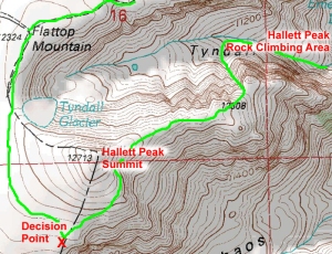
Hallett Peak (12,713′) sits on the Continental Divide between Tyndall Gorge (on the north) and Chaos Canyon (on the south).

I arrived first, for a change; Brian had to stop to remove & put away his skis, and I kept going in a fit of competitive furor.  I cannot remember the last time I beat Brian to a summit.  The Spinning continues to deliver a high level of fitness.

It was only 9:45am, but I decided to eat my lunch.  I wasn’t hungry as much as I couldn’t think when I’d have another chance. It didn’t seem fair to have to wait until returning to the car.

Even on Hallett’s summit there was no wind.  Brian spoke of the conditions being perfect for spray painting….absolutely zero wind. It was truly spectacular.

Joe on top of the world! Not really....Estes Park is buried beneath the fog in the background.

After the obligatory summit photos, I asked Brian how he was planning to descend. He shocked me by saying he was going down Chaos Canyon.

I had zero interest in that Chaos Canyon.  But Brian did make a good point when he said we needed to use these perfect days to try new things. I wavered.

I got up and walked toward Otis Peak so I could see the Chaos Canyon and Chaotic Glacier which links the canyon to Flattop.

The glacier looked steep; I thought ‘no’….too dangerous without an ice axe. But then I remembered Brian’s comment and got back on the fence.  I wanted to find a way to agree, but I didn’t want to die being stupid.

I moved back to Hallett’s summit where Brian and my gear were awaiting my decision.  I said that I wanted a closer look before deciding.

A view of Chaotic Glacier from the southern flank of Hallett Peak

We hiked down the southern side of Hallett; I took particular note of how firm the snow was on that side.  Once I could see more of Chaotic Glacier, I could see that it was way too steep if the snow was hard.  No way.  I said out loud that it would be plain stupid for me to descend something that steep with nothing to arrest my slide.  Brian gave me hope by offering to let me use one of his ski poles that had a plastic pick extending from the handle.

I agreed to continue to the top of the glacier to see how the snow felt.  If the snow was hard, I planned to turn back toward Flattop and descend the way we came up.

Once we reached the glacier at approximately 11am, the snow felt promising.  It was soft in spots, sometimes as deep as 6-8 inches; I decided I would descend Chaotic Glacier and then hike out Chaos Canyon to Emerald Lake and back to Bear Lake.  I had never descended that way before; it would be an adventure!

A view of the descent into Chaos Canyon

I traded Brian for one of his poles, per his earlier offer.  After fiddling around with the two poles, I decided that I would be better served with just the pole with the pick.  I figured that if I really needed to self-arrest, I was likely to drop both poles if I was fumbling around with two.  Then we walked together down the top of the glacier to reach the part where the slope increased dramatically.  Too dramatically. And, the steeper snow was not soft.

Was I really going to do this?  Crap.

The angle was terrible, but there were no obstructions below.  Even if I lost control, I wouldn’t hit anything.  At worst, I’d get injured.  But I didn’t want to get injured.

What was I thinking?  Okay, I would do it.

Brian started down and stopped after skiing about 50 feet to wait for me to start down.  I sat in the snow and got used to the new pole.  I envisioned how I’d use the pick to self arrest and did a practice roll over.  The pick was made of plastic and so was made thick so not to break.  The thick material didn’t want to sink into the snow and so the pick tended to roll to the side when I weighted it. Crap.

I couldn’t do it.  Could I?

Damn.

I tried going down face in with both hands on the pole with the pick buried.  It was working!  I was able to get the toes of my boots into the snow and then reposition the pick lower, and then repeat.  As long as the snow didn’t become frozen at some point below me, I would live. But now I was committed.  And that’s when it occurred to me that the pick could break-off at any moment.  These poles were 10 years old and made of plastic.  If it broke, I was going for a long, fast slide.

But I got lucky.  The lower I got, the softer the snow became.  I would live…with my parts unbroken.

Brian in a whiteout on Chaotic Glacier

I decided the snow was soft enough to glissade, and so I turned around to begin.  Suddenly, I couldn’t see anything.

The cloud bank beneath us had rolled up the canyon and now completely obscured our vision.  It is not a good idea to start sliding down steep snow without being able to see what I might hit or fall into.

I’d just have to trust that my last view of the glacier, which showed nothing to worry about, was accurate.  And, so I started.  Down I went….woohoo! And then it was over.   I made it.

But now we couldn’t see anything about where to go.  If we had to rely on simply going downhill, it was going to be a hard escape.

Then I noticed the tracks again.  I could follow the tracks.  And, if these folks could see where they were going when the hiked out, then the tracks would lead us out.

Down and down, we followed the tracks down Chaos Canyon and past Lake Hayhafa.  Visibility as still poor, but I figured we just had to keep following the tracks out toward Dream Lake, which was the only exit from Chaos Canyon, right? Keep reading.

Once past Lake Hayhafa, the terrain looked less and less trail-like. After some distance of plunging through tree branches where sunglasses were necessary as protection from poking, Brian stopped and said, “do you know where we are?”

I said I did not, but indicated that I assumed that the tracks had to lead to Dream Lake.  Brian then said, “well, we’ve been heading right (south) instead of left (north) for a while now….I think we are headed toward Glacier Gorge.”

Glacier Gorge!  He might as well have said ‘The Moon’.

I said I didn’t think it was possible to go to Glacier Gorge from Chaos Canyon.  Brian said he didn’t think so either, but that where he thought we were going, possible or not.

We looked around and couldn’t see anything beyond 100 yards.  We certainly had no way to see any landmarks to guide us. We were screwed.

Then I remembered that I had brought my smartphone, and that I might be able to figure out where we are…if I could get a satellite signal.

It worked.  Of course the screen was almost entirely unreadable in the weird light conditions, and Google Maps is not designed for optimum readability on tiny screens. But I was able to make out that we had indeed been heading SSW, toward Glacier Gorge. I pointed toward Dream Lake and then Bear Lake. Brian didn’t think turning north toward Bear Lake would work as there could be cliffs and other obstacles between it and us. We either had to backtrack or continue toward Glacier Gorge and hope we could find a path to join-up with the winter trail next to The Knob.

The Knob seemed to be the easiest choice, but, even if it was successful, we’d have to loop back to Bear Lake.  Crap.

For some reason, we stayed with the tracks that had led us to the middle of nowhere, but the tracks did seem to head in approximately the right direction.  Heck, either they made it or we’d find their frozen bodies along the way.

Another 30 minutes in and our situation hadn’t improved.  I decided it was time for another direction check.  We were still in the middle of nowhere. And, then I noticed that my battery was about to die.  I gave Brian a heading and then we stayed with it until we finally joined up with the well-established trail.
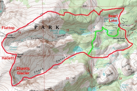
Our approximate route looping from Bear Lake to Flattop to Hallett toward Otis and then down Chaotic Glacier and Chaos Canyon, where we got lost. The line east from Chaos Canyon does not reveal the unpleasant wandering involved in such a bushwack.

We plodded along, happy to know where we were for the first time in a while.  By 1:30pm we reached the Bear Lake parking lot.  It was over.  We had taken 6.5 hours to hike approximately 11 miles while gaining and losing 3200′ plus a 100-250′ needed to wander from Chaos Canyon to the Glacier Gorge Winter trail and back up to Bear Lake.

On the drive home, Brian told me about a tale he heard from a fellow who took a bad fall skiing down Lambs Slide.  This fellow used the same poles as Brian, with the plastic picks.  When he fell on Lambs Slide, both picks broke off, sending him to serious injury.

It is plain stupidity for me to fail to bring an ice axe when venturing high in the mountains, especially given my apparent inability to refuse an opportunity for adventure.  I’ll not forget again.

Another great day in RMNP!

See all trip reports

See all RMNP trip reports

Odessa Gorge Circuit

February 14, 2010

In preparation for my upcoming 40th birthday 14er trip to bag the Crestone Traverse, I wanted to get in some snow climbing and some rock scrambling.  I suggested we try one of the cols in Odessa Gorge for a start; Brian agreed.

We left the Bear Lake parking lot at 7am and headed up toward Lake Helene.

Our route with sequence numbers corresponding to route description below

Step 1

I had originally liked the look of the East Couloir, but a team got into it ahead of us.  We didn’t want to eat rolling snow for 1000’ so we turned up the “Hourglass” (class II W14 per Rossiter); it is the middle couloir of the three Flattop Northface couloirs.

The snow was in good shape but the temperature was very warm, so we hurried to finish before the snow turned problematic.  We made good time until reaching the overhanging cornice blocking our access to Flattop.

We worried about the cornice falling on us and about us falling off the cornice, so we setup a belay behind some big boulders near the top on the left side.  Brian found/made a path over the cornice involving some tunneling and some mantling; my position off to the left provided good protection from the massive snow chunks raining down the slope.  He then brought me up and we moved a few yards east to reach the Tonahutu Creek trail.

Step 2

For the next portion of the day, the plan was to follow the Continental Divide in a traverse of the top edge of the gorge and then descend via a traverse to the summit of the Little Matterhorn.

After a short break, we headed west and then turned the north at Ptarmigan Pass to follow the Continental Divide.  A short bit of hiking led us to the back of Notchtop Mountain (12160’), which we studied for a short time, reminiscing about the climbs we’d done on that rock.

Cool view of Flattop and our snow route from Notchtop, with Longs, Hallett & Taylor in background

Step 3

Continuing roughly north along the Continental Divide, we made it to Knobtop Mountain (12.331’) where we stopped to look for a route to the Little Matterhorn.  I gazed over at Gabletop Mountain, thinking this might be my only chance to bag it, but I needed to get some rock scrambling practice in advance of the upcoming Crestone Traverse.   I stuck with the plan.

Step 4

We started down the Knobtop ridge and found the terrain, while a bit loose, was sufficient for a proper ridge traverse.  We stayed on the ridge much of the time until we reached the end of the ridge and the Little Matterhorn (11586’).  To get onto the summit of the Little Matterhorn, we had to negotiate some challenging, but with a bit of route-finding, not overly difficult terrain.  I’d call it 4th class, just to be conservative.

Joe on Little Matterhorn summit with Notchtop in distance

We scrambled up to the summit of the Little Matterhorn and found it to be a worthy summit with great views into the Odessa Lake area.  We also found a cool chimney on the north side that we descended a bit just to play around on nice rock.  I later read in Roach’s RMNP book that the Little Matterhorn is the lowest elevation peak in his book.

Little Matterhorn

Step 5

Out of water and dried up likes prunes in the hot sun, we scrambled down to Grace Falls.  At the bottom, I turned around to look at the Little Matterhorn.  I could see why it made it into Roach’s book.  It is a spectacular little peak.  And I could even see how it got the name of Little Matterhorn…it sort of looks like the real thing, just on a smaller scale.

Then we bushwhacked up to the Fern Lake trail, which we hiked to cover the 3+ miles back to the Bear Lake parking lot.  Sunburned and dehydrated, we didn’t make any attempt to make a fast escape; we were just glad to be under tree cover and heading back to the parking lot.

We arrived at the parking lot at 4:30pm for a 9.5-hour round trip covering approximately 12 miles.

Come on Crestones! (see 5 14ers for my 40th)

See all trip reports

See RMNP trip reports

Flattop Loop

December 18, 2009

In writing this trip report, the initial title was “Escaping the slippery slope of incremental decision-making on a last minute hike up Flattop” but that didn’t really work for obvious reasons.  I revised it to “The Slippery Slope of Flattop” but that also didn’t really work because it implied a trip report about slipping down a steep and/or icy mountain slope, which wasn’t true. Ultimately, I decided to go with the title you see above which accurately indicates the primary object of the trip, even if it doesn’t foreshadow any lessons learned.  I hope that is alright.

On July 29, 2000, my regular climbing partner, Brian, was sick and no one else was available for a last minute mountain adventure.   To get some exercise, I had resigned myself to a Green Mountain linkup with other nearby peaks.

My lack of enthusiasm kept me from getting a prompt start; it wasn’t until 1:30pm that I got myself ready to go.  As I was leaving home, I happened to notice that my RMNP Annual Pass was expiring 2 days hence.  In a spur of the moment reflex (I dare not call it a decision), I drove to RMNP with gear for Green Mountain.

Naturally, the traffic and parking were horrific at the height of tourist season and so late in the day.  But I was desperate and found the mental strength to push on.  I parked in the Bear Lake parking lot and started hiking at 3pm.

Wearing shorts and a tank top and without a hat or jacket, I didn’t expect to get far on my hike up Flattop.  In fact, I would have been satisfied with a couple mile hike to treeline.  I certainly started with the sense that the inevitable thunderstorms would chase me off.

As you might guess, I’m a fan of the good-plan-ready-now instead of the perfect-plan-ready-tomorrow.  But it turns out that it is also important to carefully distinguish between a good plan and a bad plan.  It turns out that starting with a bad plan leads to spur of the moment changes to deal incrementally with problems and new ideas; and the new overall plan, as seen in hindsight, can end up making no sense at all.

The standard route from Bear Lake to Flattop Mountain An 8 mile round trip gaining 2,800 feet in elevation.

But, to my amazement, the clouds in distance stayed away all the way up to the broad flat summit of Flattop.  Overjoyed with my good fortune, it occurred to me that it would be fun to finally bag Mt. Otis while I was there; I mean, it was just on the other side of Hallett, how long could it take?

But when I looked to gauge the distance to Mt Otis, I couldn’t see it.  And since I didn’t have a map, I figured the best thing was to start hiking towards Mt Otis until I could see it, so that’s what I did.

While I was moving, it occurred to me that it would be even more fun to also descend Andrews Glacier, since I’d be so close, and create a magnificent loop route.  I reasoned that the extra distance couldn’t take too much longer than just heading back down the way I came up, and I would have salvaged the day with a great adventure.

For a mountain adventure, I love a loop route.  Compared to an out-and-back or “lollipop” route, a loop route means covering and navigating more new ground.  Since the terrain never repeats, the risk of route-finding failure compounds until the final steps to safety are taken. In other words, in a loop route, there is always a chance of having to retrace the entire route until the final few steps.  Uncertainty = Drama.

My imagined route to Otis

Once I could finally see Mt Otis, I noticed that it was actually further away than I expected.  Without much of a pause, I figured I had better hurry if I was going to make it to Otis and beyond before the storms came on.

I actually did hike faster for about 5 minutes before a little birdie whispered in my ear, “YOU ARE BEING STUPID!”

The spell was broken.

Suddenly, it occurred to me that I was foolishly slipping into some very dangerous decision-making.  I didn’t have a watch with me, but I knew it had to be around 6pm.  That meant I only had 2 hours of daylight left.  And I didn’t have a head lamp, either. And like water from a breaking dam, all of my really bad assumptions started crashing down:

  • the hike down Andrews Glacier and past Loch Vale was certainly going to take a lot longer than the Flattop trail and certainly more than 2 hours before adding the time it would take to summit Otis
  • using hiking poles for a descent of a lump of ice (Andrews Glacier) probably was going to be tricky if I couldn’t find a scrambling descent along the north side (which I had done before but later in the season)
  • if I had to back off of Andrews glacier, I was going to have to retreat all the way back over and down Flattop, potentially a 3+ hour affair that would start just as it got dark
  • and I was essentially naked with no extra clothes in case I did become caught out in a storm or after dark or both.

This was just too stupid, even for me.  I backed-off.

But I hadn’t completely lost my nerve.  It occurred to me that there was another way that would be shorter than going back down the Flattop trail; and it would involve only a small gamble.

My imagined escape route back to Bear Lake

I decided to head northeast to find the Hallett Peak climber’s descent gully which I’ve used many times to descend into Tyndall Gorge for the hike back to Bear Lake, passing Emerald and Dream Lake along the way.  I just hoped that there were no impassible obstacles between me, standing near the top of Chaos canyon, and the climber’s descent of Hallett peak.  I bet my life that there weren’t.

Rough route taken up Flattop and down Hallett. Note: photo from a different trip.

I started with a very fast pace and quickly found that the ridge from the summit down to the climbing area was unbroken.  But I also found that finding the descent gully was hard coming from the “wrong” direction.  Every gully started to look like the descent gully and I had to check out every one to avoid passing it by.  But eventually I came to the right one; it looked just like all the other gullies except for a few details that I couldn’t remember until I saw them.  It would have been impossible to figure out how to get down without direct, personal experience with the terrain.

The descent gully is a loose mess, but it goes.  And I was able to get my body, including a just recently functioning brain, down to the Tyndall Gorge in working order.  Then I worked my way down past the climbing area which was devoid of climbers at that late hour.  And straining to beat the sunset, I hurried down to Emerald Lake and reached the easy hiking trail with plenty of light left.

I had the trail to myself as I made my way past Dream Lake and then Nymph Lake, and finally to the Bear Lake parking area.  I reached my truck right at sunset for a 5 hour round trip.

On this trip, my biggest danger was my own carelessness.  But, hey, I got in one more Rocky Mountain National Park adventure before my pass expired. And I got a cheap reeducation on mountain sensibility.

The routes imagined and taken

Thatchtop Traverse

March 14, 2009

Story

While reading Rossiter’s High Peaks guidebook, I found a passage that said, “…or you can descend via Thatchtop – it’s only 4th class…” I love traverses and so I decided I would use the traverse to the Continental Divide to bag Mt. Powell (13,208′) after summiting Thatchtop Mountain (12,668′) and then use it again to get home.

Foolishly, I got a late start – only hiking by 8:15am.  And I had to start from Bear Lake, since the close lot was already full, adding 15 minutes to the hike in.  I reached the foot of Thatchtop Mountain around 10am, and hoped I had four hours before any bad weather might start.

I started up the wooded east slope toward a gully I hoped would lead past the cliff band that separated me from the flatter summit slope above.  The climbing was ugly and dirty as is typical for an unpopular hike, and for a slope enduring a recent avalanche; scrambling over fallen logs and avoiding sharp, broken branches added to the delays.  (Note:  on a subsequent trip in 2010, I discovered I was badly off-route.)  Finally, I was able to look up the gully and confirm that only a few moderate moves would take me past the cliff.  And by 11:30am, I was enjoying my barely earned but desperately needed water on the Thatchtop summit.  I was also enjoying the great Glacier Gorge view, lined with my favorite RMNP peaks:  Longs Peak, Pagoda Peak, Chiefs Head, and McHenry.

From the summit, I noticed the western sky was blocked by McHenry Peak and the nearby Continental Divide (both close and above me).  I was worried that I would not have any advance notice of approaching weather; but I figured I could turn around later.  And I hoped my long-standing good weather luck would continue.

Leaving the summit, I began the traverse with a full sense of thrill.  With a shot of adrenaline, my mind became clearer and better focused on the work at hand, my body became more coordinated and better balanced, and my mind adopted a higher pain tolerance.  It was the easiest climbing of the day.

I stayed on the ridge whenever possible and moved a bit lower to the south when necessary to avoid difficulties such as cliff-outs or gendarmes.  I was still making excellent progress when the rain and lightning started.  It only lasted a minute, but the lichen-covered rock was now slick; the further I went, the more difficult the climbing became.  I thought about going back, but felt that the climbing I had done would be too hard to do again when slick, so I kept going.  Besides, I was very close to achieving my goal. (Note:  on my 2010 return visit to the area, I discovered that my ‘stay on the ridge’ strategy was unnecessarily hard; a much flatter, safer path was mere yards down the slope)

I kept thinking the hard part must be behind me, as it was “only 4th class.”  But then I reached what must have been the normal crux.  In dry conditions, it would have been a difficult climb over a knife edged ridge, but wet, it was impossible.  I couldn’t even climb up the sloping rock to start the knife-edge due to the slick conditions.  I hunted around and found a passage around to the north side:  atop a 1,500 foot cliff hanging over Sky Pond, there was 1 foot wide ledge that would lead back to the ridge beyond the crux; but the start of the ledge was six feet away with only a 2 x 1 inch sized foot hold protruding from a sheer rock face with no hand holds between me at the ledge.  During the 2-second move, I would have only the toe of my boot on the mossy hold with nothing else holding me up as I long-stepped through to the ledge six feet away.  This was not the sort of fun I was hoping to have.

thatchtop

In a state of denial, I went back to look for something else and to consider retreating over the difficult ground that I had passed to get here; but I once again decided I had no choice but to proceed.  And I couldn’t wait as the rain and lightning had started again.  I was able to hang on to a rock while I stuck my foot out to kick the horrible foothold to see if it was strong (it was) and to clean it off.  And then I put my boot toe on the hold, weighted it, and stepped through.  Fortunately, I was able to stay focused on the move and not be distracted by the potential fall or the lightning.  After the relief of not dying wore off, it hit me that there was no way I could go back now.  I simply had to find a way to the Continental Divide and then find another way home.

Fortunately, the rest of the Thatchtop ridge was much easier, and I was even able to get some shelter below Mt. Powell when another fast-moving lightning storm blew in.  With a brief bit of good weather, I was able to get the Mt. Powell summit (Note:  on a later trip, I discovered that I missed the actual, and obvious, summit by 40 feet) and begin my long trek home.  I figured that the only safe way back down was to traverse north beneath Mt. Taylor and then on to Flattop (~4 miles away) and then down the established trail to Bear Lake (another 4.4 miles).  This way I would stay beneath the high points and avoid steep descents on snow, but I would still be exposed to lightning for a long time as I worked my way to the treeline near Bear Lake.  The only reasonable alternative was Andrews Glacier between Mt Taylor and Mt Otis, but I just didn’t think it would be safe to attempt without an ice axe.

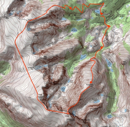
My circuitous route back to the Bear Lake parking lot, to avoid the return traverse of Thatchtop

My circuitous route back to the Bear Lake parking lot, to avoid the return traverse over Thatchtop

Much rained on, badly dehydrated, and having hiking through a large herd of Elk, I arrived at Bear Lake and my car at 7:15pm. I hiked and climbed a 12.5-mile circuit in 11 hours, and felt lucky to be alive.  But at least I got my 15 minutes back as I didn’t have to hike any farther than Bear Lake.

The next two nights I slept badly with dreams of falling down a cliff toward Sky Pond.

Complications

  • The route was not well known (not described in detail).
  • “4th Class” is a subjective rating
  • It wasn’t clear if it was one difficult section or several difficult sections
  • The route did not have a good “retreat” option (as is typically true of ridge traverse climbs)
  • The weather was poor
  • I was hiking/climbing alone

Mistakes

(1) Prepared Badly

  1. Didn’t think about the ramifications of being late when driving into a popular destination:  traffic, parking, etc.
  2. Didn’t imagine “what if I cannot return via the ascent route” (didn’t bring an ice axe)
  3. Didn’t consider the impact of possible rain on the “4th class” rating (I brought rock shoes, but wasn’t prepared to react aggressively to initial rain)
  4. Assumed my turnaround time was 2pm instead of noon.

(2) Made several bad decisions along the way due to flaws & biases in my thinking.

  1. Justify-Past-Actions Trap:  I didn’t want to waste my efforts, so I resisted turning around when the initial rain fell and the conditions became much worse than I expected.
  2. Optimism Bias:  Felt overconfident about unknown terrain; I consistently thought the climbing ahead of me would be easier than the terrain I had passed even though I had no facts available. This kept me from retreating when I could have done so.
  3. Gamblers Fallacy:  Felt I could count on being lucky with the weather since I had been fortunate many times in a row.

How I Got Lucky

  1. The weather was only periodically stormy; most of the time I was on the Continental Divide the sky was just sprinkling.
  2. I made it past a move with a 50% chance of success, when failure meant death
  3. I found a puddle of clean rain water to drink on the long descent hike
  4. I knew the area well enough to figure out a completely different route to descend without a map

Note:  After my later trip to bag the Solitude Lake Cirque, and my discoveries of even more stupid mistakes I made on my Thatchtop Traverse, I am even more amazed at how my carelessness  magnified the overall challenge and forced me into needless risk-taking.  Wow, what a lesson!

Go to “Learning from Mistakes” index

Go to Index of all essays