Posts Tagged ‘13ers’

Much Ado About Nothing on Chiefs Head

February 16, 2010

For eight years, one of the most significant rock formation in RNMP had stared us in the face every time we’ve ventured into Glacier Gorge, and yet, we’d never thought to venture onto its features.  Primarily, our lack of attention was due to the very long approach, but in some important way, its forbidding and committing look was also a deterrent.

The guidebooks didn’t paint a rosy picture, either.  Rossiter’s guidebook says…

The Northwest Face of Chiefs Head is one of the finest alpine walls in the contiguous United States.  The immense and unusally smooth oval face rises a thousand feet…and is home to some very aesthetic and very hairy routes.  All of the routes have long runouts and no fixed anchors[.] In the event of storm…it is very difficult to escape.

Plus, all the routes seemed to be 5.11X or 5.12R, so our attention was rightly elsewhere.  But one day, Brian sends me an email:

Joe:

How about “Much Ado About Nothing”.  This is about the only climb on Chiefshead that isn’t 5.10 or above.  It’s way right of the big wall, and has five pitches, with the last one 5.8.

Brian

My thoughts were along the lines of: Heck yeah!  Only 5.8, really?  Why haven’t we done it before now?  And we can bag another Chiefs Head summit! I responded via email with agreement and a question about the descent.  Brian replied:

Joe:

Descent may be most interesting part.  Stoneman could be done, but it would be a long way back to pick up packs.  Rositer recommends rapping down his Birds of Prey route, but first you have to find it.  And find it empty.  The third choice is a third class route much closer than Stoneman. Finding that route could be valuable knowledge.

Forgot to mention:  this climb gets no star in the book.  But I thought it would be worth it to do something on that mountain.

Brian

I wondered about the “no star” thing, but was already enthusiastic about the climb. They say, ignorance is bliss, at least for a while.  Soon, we’d find out just how wise it is to be afraid of Chiefs Head’s Northwest Face.  We find out just how hard Chiefs Head climbs really are, even a mere 5.8 route.

The Story

On the morning of August 23, 2003, we caught the 5am shuttle bus (earliest available) to travel up Bear Lake road as we set out for the far end of Glacier Gorge. We had to hike approximately 7 miles and over 3,000 vertical feet just to reach the start of the climb:  we hiked up past Black Lake, over the north shoulder of Spearhead, past Frozen Lake and beneath the west face of Spearhead, and then we scrambled up a rocky shelf before crawling up the snowy talus to reach the northwest face of Chiefs Head.  Then, we turned west and climbed up the snowy ramp to reach the base of the climb.  It was a brutal 3.5 hours; and we hadn’t even started the climb.

Our route plus alternative descent routes from Chiefs Head

Prior to reaching the base of the climb, we stopped for a moment of study while we could still see the entire wall.  The key was the figure of a head that would guide us to know where to start and where to aim during the initial pitches.  We were looking at shadowy patches trying to find one that looked like a head; Brian claimed to be able to see an “Indian’s head” but I could not.  But with a target in hand, we finished the approach.  Just before 9am, we started up the Much Ado About Nothing route on Chiefs Head’s Northwest Face.

Pitch 1

I took the first pitch and climbed over steep, broken ground that was supposed to end at the base of a “head” I could not see.  I could do no more than take out as much rope as I could and find a good spot to belay.

Pitch 2

Brian took the second pitch, following huge broken flakes that provided small left-facing dihedrals on their left side.  He finished over some easy ledges and belayed at the base of a left leaning ramp.  At this time we noticed that the weather was worsening; our view west was blocked, but the sky above was clouding up and darkening.  We knew we had to hurry since the crux was still ahead.

Pitch 3

I took the third pitch which was to climb the ramp leading up and left angling toward a big dark roof that stretched for more than a pitch as it arched left.  To save some time on an easier section, we decided to simul-climb. Using the ramp to travel diagonally under the  roof started out easy, but then steepened.

And then the rain started.  It was a only a drizzle, but now we were in it.  It was approximately 12pm.

The crux of the climb was still ahead; I knew we had to get past the slabby crux before the lichen turned into grease.  I put in a quick belay with about 1/2 a pitch of the roof remaining so Brian and I could put on our rain jackets. We then moved the belay to below the crux pitch so Brian could race the weather past the crux.

Pitch 4

Just as Brian arrived at the end of the ramp, the rain began again in earnest.  We could see the next ramp approximately 30 feet above us; Brian had to get there before the rock became unclimbable as well as unprotectable (a slab).  He started quickly but soon slowed as the  rock was quickly getting slick.

As I sat in the freezing rain, I could feel the water soak thorugh my rain jacket.  As I watched Brian slowly working his way up, hoping he wouldn’t take a long fall, and as I got colder and colder as my clothes became more and more wet, I came to understand just how important it is to have proper gear when venturing into hard to escape terrain.  Apparently, my windproof, water resistant, insulated and wonderfully packable North Face jacket was not up to the challenge of a real Alpine adventure.  I was going to suffer terribly as a result.

Brian decided to stop before the ramp, but after the hard section, to allow me to get past the crux before it became too wet.  But it was too late, the rock was completely drenched, and I was certain I could not climb the rock.  I was mentally prepared to “fall up” over the slick rock.

And it was like climbing a greased slope, but 3 points of contact allowed me to cling to the rock like a spider in the shower.  Once I reached Brian, we quickly moved the belay up to the ramp so we could figure out where we were.

Pitch 5

We were very confused because, according to the information we had collected, we should be at the summit ridge already.  But there was no summit ridge in sight.  It turned out that Rossiter’s topo only showed the unbroken portion of rock that was set into and below the full NW face.  We didn’t have any certain knowledge or clue as to how to get to the summit ridge.

All we could do was follow the ramp we were on and then follow our noses to try to find the rappel anchors or at worst take the summit ridge down to either Stone Man Pass or find the mysterious “broken ramp” that Rossiter described as an ascent route to the right of the Much Ado About Nothing route.  But first things first.

I took the lead for a simul-climb of the ramp.  After a couple hundred feet with no rap anchors or anything else looking promising, I found a right leaning ramp that promised to intercept the ridge as it sloped down. Desperate for any escape, I abandoned the search for rap anchors and took the right leaning ramp.  It went, and I was able to piece together a climb off the face.

Yes!  We made it.

While I was sopping wet and freezing cold, I now had control over my fate; I knew that I knew how to get home.  I just needed to escape Glacier Gorge before it got dark; it was approximately 3pm.
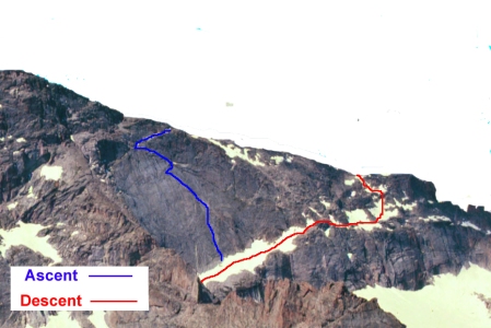
Much Ado About Nothing route plus descent. Photo from Longs Peak of Chiefs Head edited to highlight Chiefs Head features by removing other peaks (e,g,m Mt. Alice) from the background.


Descent

Shivering with no hope of getting warm, I had no intention of continuing to the Chiefs Head summit.  I wouldn’t have done it even if I had never stood on top of Chiefs Head.  I felt that my life was in play and wanted to take no unnecessary chances.

Brian thought he could find the gully that Rossiter described as an ascent route; from a safety, time & energy management perspective, we desperately wanted to avoid going all the way around to and down Stone Man pass.  We hiked down the much of the NW Ridge to find a likely big gully to descend.  It was more like a series of steep gullies that would work for 40 feet, then we would have to find ledge that would allow us to traverse to another gully.

We kept trying to turn back to the east where the climb started, but each time all we could see was a difficult ledge heading east and then a rock rib would prevent us from seeing whether the ledge continued.  Brian said it reminded him of Pyramid Peak.

Eventually Brian found a ledge that led out to the biggest rib, and from there he could see the start of the climb, and sloping, rubble-covered ramps leading down to it.  We scrambled down and followed it until the terrain started to break up; a path to the right appeared and we took it, hoping it would lead to the snowy ramp we started on.

We had to retrace our steps a couple times as we’d cliff out, and then we split up to double our chances of finding an escape path.  Eventually Brian found a path through tumble that worked.

It was approximately 5pm.  Three hours of light left.

We packed up our gear and headed down as fast as we could manage.  We were going to get caught out by darkness; it was only a question of how much hard hiking we had to do in the dark without headlamps.

We retraced our steps so not to introduce any new variables, and we made it to within a quarter mile of the Bear Lake road before it became too dark to see what we were doing.  Since the buses ran until 10pm, we took our time creeping in the dark to find the Bear Lake road.  Once there, we started downhill and found a small group of people standing by the road.  We confirmed that it was the bus stop and then we layed down on the pavement to wait for its arrival.  We had spent our last ounce of energy.

We made it.  We had hiked 15 miles, and climbed nearly 4,000′ in over 15.5 hours.  And this time we had overcome serious route finding problems, freezing rain, and one serious case of rain gear stupidity to make it home once again.

It was a glorious adventure.

See all trip reports

See all RMNP trip reports

Swimming Atlantic & Pacific Peaks

August 3, 2009

I had 14ers on the brain, but the unchecked peaks were too far for a day trip, and Brian couldn’t get away for an overnighter. Brian suggested we do “Atlantic” as it is nearby (near Copper Mountain) and would provide a good ski descent.  We could also add in Pacific if we made good time. I agreed.

Our plan for April 13, 2002 had 4 easy steps:

  1. Follow the mining road until we could cross the streambed to pass between Mayflower Hill and “Atlantic Peak”
  2. Ascend the West (summit) Ridge to “Atlantic” and proceed east to the summit of “Atlantic”
  3. Traverse to Pacific Peak, if time, conditions, and fitness permit
  4. Descend back to the trailhead and reach home alive
Our route from the Mayflower Gulch TH to Atlantic and Pacific Peaks

Our route from the Mayflower Gulch TH to Atlantic and Pacific Peaks

And everything started off so well….

We left the Mayflower TH parking lot around 7am and made good time along an old mining road.  After about 1 mile we turned to head NE up a stream bed headed between “Atlantic” and Mayflower Hill toward Pacific Mt.  Before leaving the road, I put on my snowshoes for floatation, which I brought instead of skis to give my aching knees a rest.  My optimism was not well founded, but at least I could blame this one on Brian.

Fletcher (right) and Atlantic (left) on the way to the Atlantic & Pacific peaks

Oh, the soft snow misery!  If only I was postholing…but I was drowning.  I needed snowshoes the size of freight trains.  The snow was at least 5 feet deep and soft as far down as I dared during my tank-less deep dives.  I had fallen into a giant bowl of sugar and had move through it to find an escape.  It took us 1.5 hours to travel ½ mile.  It sucked, big time.

Finally, we reached the Atlantic-Pacific cirque and mounted the Atlantic West Ridge.  I was ready for better conditions, but I wouldn’t find it.  The ascent required a steep climb up a wall of loose rocks covered by thin layer of fresh snow.  It was a slog.  But at least the ridge proper was much easier, with a lower angle and exposed rocks for footing.  We reached the Atlantic summit around 1pm.

The wind was stiff and cold, but I needed a rest as well as some water and food.  I sat on the eastern slope and ate my lunch despite a rather uncomfortable sitting position.  We decided to keep going to descend into the valley below from Pacific’s summit ridge.

The ¾ mile traverse (and 400 foot altitude gain/loss) went quickly.  The Pacific summit rose to a point, 2 feet by 2 feet…just as a summit should.  Without a pause, we immediately turned down the west ridge toward a tongue of snow which would lead us to the foot of the mountain.

Pacific is a twin-peak with no easy way to get down the west ridge.  As we skirted the west (lower) town, I had to down climb a loose rock chimney. I stepped into the chimney putting my left foot on a questionable foothold.  I proceeded only because I had good holds for both hands, although, my left hand also held my collapsed trekking poles.  My right hand held a jug on a large detached block. As I lowered myself to the next foothold, my only foothold failed…the rock broke off!  As my weight suddenly shifted to my hands, my right hand hold failed.  The detached block shifted and pulled out of its slot.  My mind raced for options and a quick glance revealed no other holds.  To buy a few milliseconds, I continued holding the detached block as it toppeled out and down toward my head.  As I twisted to avoid the rock, I shifted my right hand from the falling rock up to the ledge where the detached block once rested.  In the meantime (all 1.2 seconds of it), I traded a wrenched left shoulder and chest muscle for my life.

As I explained to Brian afterward, “it was a good trade.”

Fairly quickly we reached the tongue of snow that reached to the valley below.  The snow was a bit soft, but still allowed for a fun descent.  I had a fantastic glissade off the summit ridge.

Naturally, once we got down to the streambed, it was worse than before.  The snow was hell.  I tried to stay in my old tracks to find any purchase, but the snow had turned into quicksand.  The snowshoes provided no floatation, but instead became anchors that would hook under any vegetation beneath the snow.  I ended up taking off the snowshoes and just crawling back to the road….I didn’t know if I’d drown or go crazy first.  When I finally reached the road, I just rolled onto it out of the snow…and then let loose a blue streak of curses until my remaining energy was exhausted. It was the worst experience of my life.

But once I got back to the truck, it had turned into a great day!  And after all these years, I finally started to get an inkling of what that Dickens fellow had been talking about.

The Great Cirque: Meeker to Longs traverse

March 10, 2009

The idea for the Mt. Meeker to Long’s Peak traverse came to me last December after climbing Mt. Meeker on a clear, cool morning.  Sitting on the Meeker summit rock, I looked over the Loft to Longs Peak and saw the potential for a beautiful traverse.  At that moment, I decided I would come back to bag the two-summit traverse.  The idea eventually grew into a quest to bag “Colorado’s greatest mountain cirque” (Roach).

Of course it is a long bit of hiking, but there is also a short technical obstacle to overcome:  Mt Meeker and Longs Peak are separated by “The Notch”.  The Notch is a gap in the rock approximately 75′ deep at the ridgeline and which continues as a deep and steep gully down each side of the mountain.

Nevertheless, where there’s a will . . .


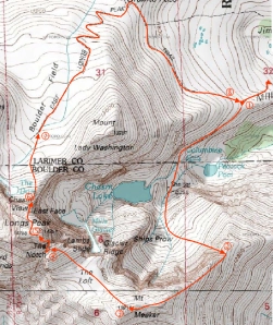
The Great Circ Route

The Great Circ Route


Brian and I were recovering from a full summer of rock climbing and related injuries, so I was able to convince Brian to do an alpine hike.  To do the entire cirque, we chose to start the loop at the Longs Peak  cut-off to Chasm Lake, which we would take toward the Mt. Meeker East Ridge, and after summiting on Meeker and then Longs, we’d return via the Boulderfield (about a 5 mile loop).

In total, the Great Cirque trek would take approximately 12 hours including the hike from and to the parking lot and would cover approximately 15 miles and an elevation gain of approximately 5700′.

Our plan had eight steps:

  1. Hike from Longs Ranger station toward Longs to Chasm Lake cutoff
  2. Hike past Chasm Lake and up through Iron Gates (class 2) approach to Mt. Meeker East Ridge
  3. Traverse Mt. Meeker ridge (class 3) to summit
  4. Descend to Loft & hike (class 2) to high point on Loft north side
  5. Descend Gorrells Traverse route (4th Class crack system) to Notch gully and ascend to Notch high point (class 4), and then climb to Longs ridge and summit using the 5th class rock finish to the Notch Coulior route
  6. Descend Longs North face via Cables route (two single rope rappels) to Chasm View
  7. Hike to Boulder Field
  8. Hike around Lady Mount Washington to complete circuit at Chasm Lake cutoff

Alternatives to avoid carrying ropes and difficult scrambling:

  1. Take Clark’s Arrow from Loft to join Keyhole route – avoid 4th class chimney and technical pitch
  2. Take Keyhole route from Long’s summit back to Boulderfield – avoid rappels

Time table:

  • Start hiking – 4am
  • Reach bottom of Iron Gates – 7am (first light)
  • Mt. Meeker summit – 9am
  • Long’s Peak summit – Noon
  • Reach car – 4pm

Report

Brian picked me up at 3am.  I was ready to go when he arrived, for a change, and we immediately headed out of Boulder for Lyons, and then the Long’s Peak Ranger Station parking lot.  We arrived just before 4am to find a parking space right in front.  A good omen.  The cold weather a week earlier must have suspended the weekend cattle drive for Longs Peak.

We powered up the trail needing only long underwear to stay warm despite the high winds and temperatures in the 30’s.  Around 5:30, still an hour or so before dawn, we reached a popular rest stop, the fork to Chasm Lake (left) or the Boulderfield (right).  The frigid winds eliminated any thought of a rest and we hurried onward toward  Chasm Lake to find some shelter.  We found a suitable rock formation approximately 300 yards further where we could stop to put on fleece and wind jackets.  My numb fingers made me regret leaving my regular gloves at home, and I would later find another reason to regret bringing only fingerless gloves.

The trail from the Ranger Hut below the Ship’s Prow (rock formation which separates the canyons below Mt. Meeker to the left and Long’s Peak & Chasm Lake to the right) to the Iron Gates is indistinct and generally over talus.  We knew the Iron Gates gully ran up the left of the buttress which is to the left of Cathedral Buttress (the awe inspiring buttress which runs down from the Mt. Meeker summit to the canyon floor), but of course this is difficult to see in the twilight.  Fortunately, a moment of hesitation allowed the sunrise to show us the path.

The Iron Gates gully proved to be a wonderful route to the Mt. Meeker East Ridge.  At the top of the 2nd class gully, a short 3rd class scramble brought us to the ridge and the endless vistas of the Eastern and Southern horizons. More importantly, an eastern view brought us exposure to the sun on a cold windy morning.

We paused to enjoy the radiation, eat a quick snack and apply sunscreen. After a few minutes, we continued on our quest.  This leg of the cirque led us west up the ridge toward the Mt. Meeker summit.  The easiest path was the ridgeline itself, which slopes about 20 degrees to the south (left) and 90 degrees to the north (right).  With the wind gusting up to 40 mph, we took care to avoid becoming a cliff diver and wasting all our efforts.


Our route from Meeker

Our route from Meeker


In a couple places, the traverse exhibited a common 4th class difficulty: it was 5th class without good route finding instincts.  We reached the summit at 9am with increased respect for the smaller sister of the mighty Longs Peak.  The summit itself is an unlikely square block sitting about 4 feet higher than the surrounding rock.  Underneath the block is an alcove that provided shelter from the wind and a nice spot for another snack.


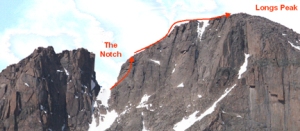
The approach to and descent into the hidden Notch (dotted portion), then the ascent to the summit

The approach to and descent into the hidden Notch (dotted portion), then the ascent to the summit


We continued the traverse across the ridge and then down to the Loft, following the natural line.  In order to find Gorrells Traverse route on the far side of the Loft, we angled toward the high point (North end) of the Loft that forms one side of the Notch.  The Notch separates the Loft from Long’s Peak and prevents the easy hike to Long’s summit.

Gorrells Traverse route is a 4th class crack system  that descends into the Notch gully, SW side.

Per Rossiter’s guide book, RMNP: The High Peaks:

Hike NW to the highpoint of the SE ridge above The Notch. Descend to the west and locate cairns that mark the tops of two chimneys.  Downclimb the north chimney for about 200 feet to a broken platform that is about 100 feet above the gully leading up to The Notch.  Rappel into the gully from the north end of the platform or traverse up and left toward The Notch until it is possible to scramble down into the gully.


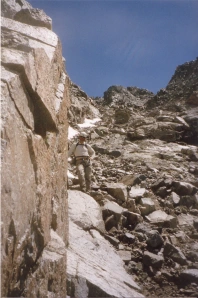
Gorrells Traverse

Gorrells Traverse. Photo from a later trip.


As in all guide book ratings, the rating is right if your technique and route finding is up to snuff.  There is also well-used rappel anchor for the unsure. We jammed down the cracks:  blind feet and bomber hands.   I got a tear in my wind jacket for the effort.  At the bottom of the first downclimb, we traversed right and slightly uphill to reach another gully which we downclimbed.  It was quite exposed but went rather easily as well.  From the bottom of the downclimb, we turned right and scrambled up to reach the top of the Notch.


Our route from the Notch to Longs Peak summit

Our route from the Notch to Longs Peak summit. Photo from earlier trip.


From the top of the Notch, we could see down the Notch Couloir toward the Broadway Ledge.  We also speculated on the feasibility of a tyrrolian traverse across the Notch without conclusion.  Since the rock was still non-technical at that point, we continued scrambling and moved out of the Notch toward the summit ridge.  We got to within 90 feet of the ridge before we ran out of scrambling terrain.

Since we brought rock gear, we didn’t feel compelled to stay with the Notch Couloir route (rated 5.2); in fact, we specifically wanted to find something more interesting…more memorable.  Brian spotted a rappel anchor at the top of the Long’s side of the Notch, approximately 90 feet above us; we agreed to climb toward it over the moderate looking moves.


A view of the technical climb to reach the summit ridge

A view of the technical climb to reach the summit ridge


We roped up and Brian took off for the ridge, his hiking boots scraping on clean 5.5  rock.  Our “mini-rack” of climbing gear was sparse enough to fit in a coat pocket, but it turned out to be ideal for a short pitch at 14,000 ft. elevation.   Near the top, Brian decided to pull a roof directly above rather than take the obvious ramp to the left.  When I questioned his intentions (with a yell from below), he explained, “you’ll thank me.”  Later, after pulling over the top on monstrous buckets, I did.

All that was left was the short but interesting ridge scramble and then a walk to the summit marker, which we reached at 11:54am.  We rested in luxurious bivy site and congratulated ourselves for a great trek.  It was, after all, quite literally all downhill from there.


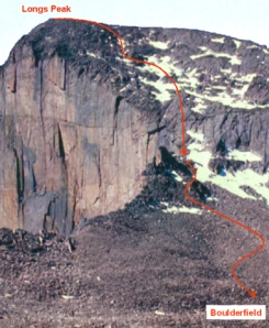
Our descent route to the Boulderfield

Our descent route to the Boulderfield. Photo from later trip.


The descent through the Cable Route was interesting as a result of snow and ice adding frictionless treachery to the loose rocks in our path.  I lost my concentration on a relatively flat section and slipped on the ice.  My fall on the rock sheared off the front half of my right thumbnail.  This shockingly painful and bloody injury would cause me considerable grief during the rappels to come.  We scrambled down to the lower rappel anchors and made it to the Boulderfield in good time.

The hike out of the Boulderfield is always a death march, but this time I felt so good about the climb that I didn’t mind it at all. We reached the car at 4pm and drove into Lyons for some Mexican food.

It was all good, I just shouldn’t have ordered fajitas. They’re too hard to roll with just one hand!

See all trip reports

The Three Apostles

March 7, 2009

Ice Mountain had long been on my list of peaks to carefully and proudly summit.  Many years later than I expected, I finally arranged a weekend trip to collect it and the other two Apostles.  The plan was to get the Three Apostles (North Apostle, Ice Mountain & West Apostle) over the June 24-25, 2006 weekend, doing all three peaks on a single day.

Our route path

Our route path

We met after work on Friday and drove to the 4WD trailhead for a few hours of sleep.  We arose and left camp at approx. 5am on Saturday.   

It was a humid place (river, puddles, lakes:  water everywhere) and the temp was around 30F.  My small pack and a sunny day forecast convinced me to leave my bulky fleece in camp.  And it was the right decision, but I did suffer for the 15 minutes it took to work up a full head of steam.

Worst Physical Discomforts
1. Nausea  (afraid you won’t die)
2. Cold  (afraid you will die)
3. Pain  (fear of permanent damage)
4. Hunger  (true mental torment)
5. Dehydration  (slow misery)

Within minutes we reached the TH which had two trails:  one was marked “Huron Trail” and the other one wasn’t.  We started toward the 3 Apostle’s Basin (as best we could tell) at a very fast pace to work up some heat.

We stayed on the obvious trail until we came to a well-signed fork:  Lake Ann (to the right) and Apostle’s Basin (to the left).  The Lake Ann alternative immediately crosses a substantial footbridge.  We went left and followed without difficulty a good trail (including a log creek crossing) to the terminal moraine between Ice Mountain and West Apostle. 

From the moraine there was no distinct trail, so we angled left toward North Apostle around the cliffs at the foot of Ice Mountain until we reached a lovely grassy ledge.  From this vantage point, we were able to triangulate on a probable position using Huron and our map.  Deciding that were below North Apostle, we angled back toward Ice Mountain up and into the couloir between North Apostle and Ice Mountain.

It is very good to be lucky in the mountains, and we got very lucky and received a beautiful day.  The moderate temperature and light wind made for one of the most comfortable approaches I’ve ever had.  And the views of Mt. Huron and the surrounding peaks were awe-inspiring.  A great start to a hard climb. 

Missed water refill lake in background

Missed water refill lake in background

I intended to stop for water at the tiny lake shown on the map at 12,100ft but we found ourselves 100 feet above it before we spotted it.  Rather than descend to get the water, we continued upward to some running snowmelt a few hundred feet higher, where I managed to slip on some ice and nearly tumble into a watery grave far below.  We continued up past a snowfield extending down from a fine looking couloir that reach up to nearly the top of Ice Mountain’s Northeast ridge.  All that was left to reach the saddle between North Apostle and Ice Mountain (13,100ft) was a section of large & rather loose talus blocks. 

After a brief rest on the upper saddle, we hurried up and then down North Apostle with some very easy scrambling. And then we readied ourselves for the crux of the day…Ice Mountain. 

The plan for the day was to try to make the Ice Mountain Northeast ridge work and then bag West Apostle before heading back to camp.  However, if the conditions were too dangerous, we were prepared to back off and reattempt from the much easier West Apostle side on Sunday.  Naturally, we’d rather finish the three peaks in a single push to minimize the approach hiking. 

Rule of Pride

The first rule is to never take a big chance for pride.  Think about having to explain to St. Peter (or whomever) how you died.  If you don’t like the way it sounds, don’t risk it

A view of Ice Mountain NW Ridge

A view of Ice Mountain NE Ridge

The route up the Northeast ridge was rather exposed but quite solid, and the path was well beaten most of the way.  We reached the end of the climbable ridge and began following the directions we’d found in Roach’s 13ers Guidebook.

Steps to overcome crux:

1. cross the top of a steep couloir on the ridge’s west (right) side
2. climb around the left side of a large block (class 3)
3. climb up along the couloir’s west (right) side

The first step was obvious and only a little exposed; we had no trouble with it.  But the second step was impossible as we could not find a “large block” anywhere.  Brian thought the chimney straight overhead might go, but I wanted to continue to look for and follow the established route.  We didn’t see any way to “climb the right side” of the couloir we were in, so we crossed over (right) to the next couloir (hoping it was the “right side”) and climbed up the horrid, loose, black rock which I’d grade as technical (low 5th class).  

On top of the technical difficulty, the rock was very loose.  I had to test 5 holds to find one that I was confident in trusting with my life.  In hindsight, the chimney above the initial couloir we crossed when we left the ridge was probably the correct route.  Our Loose-Black-Rock-of-Death route topped out at near the summit level, and we quickly reached the summit block at approx. 11am.

It was borderline excessively risky, but we felt our rock climbing skills would be enough.  Since it was only a moderate gamble, I was prepared to explain how it all ended.

Just before traversing to the Ice/West saddle

Just before traversing to the Ice/West saddle

We rested a few minutes while pondering our route-finding difficulties, and then headed down the large gully that runs directly down from the summit to the West Apostle side.  This gully quickly joins another gully that runs down from the crease in Ice Mountain between the real summit and false summit.  The footing was more secure that it appeared or had any right to be, but still the descent was long and tedious.  We continued down until the ridge to the right (descending climber’s right) got low enough to easily mount (also when the cairns begin).

At this point, according to our route plan, we were supposed to do a descending traverse to the headwall on Ice Mountain above the saddle (now visible) between Ice Mountain & West Apostle.  There is no clean line as such on this hill; we traveled in more of a descending zig-zag fashion, like the edge of a toothy saw laid on a declining angle.  At least we had a solid idea of where we needed to end up, and so we just kept hopping gullies until we reached the headwall.  And I managed to survive yet another stupid talus hopping mistake.

At the saddle between Ice Mountain and West Apostle, we could see some dramatically steep snow descending toward the terminal moraine we skirted earlier that morning.  The views stirred our imaginations about a fast descent, but we soon settled on the duty at hand.  We had to climb up 500ft to reach the last of 3 summits on the day, and then still get down in one piece.  I was very tired, but had a food bar and ½ liter of water to power me home.

The remaining hike over and down West Apostle was the easiest ground of day.  We got down to the far side of the West Apostle and found to our delight that there was enough snow left to use for our descent.  I used a glissade to erase 700 feet in quick order, while Brian decided to plunge step, and practice his self-arrest technique a few times.  Finally, we worked back toward Lake Ann and a much needed water re-supply.

My glissade toward the terminal morraine

My glissade toward the terminal morraine

The rest of the hike to the TH/Camp was uneventful except for a couple horrible cases of fire-toes.  Back at camp sitting in a camp chair with my boots off, and eating watermelon, fire roasted sausages, and re-hydrated spicy noodles was wonderful conclusion to a perfect day.  Note:  all credit to Brian for the camp pleasantries; I couldn’t be trusted to even bring a pillow for myself.


# Description

Altitude Gain

Altitude

(approx.)

Time Spent

(incl. breaks)

Time

(approx)

  TH/camp

0

10,600


5:00am

1 Hike to bottom of N. Apostle / Ice Mountain couloir

1,300

11,900

1.5 hours

6:30am

2 Climb talus/snow to N. Apostle / Ice Mountain Saddle (see photo)

1,560

13,460

2.0 hours

8:30am

3 Climb ridge to N. Apostle summit and return to saddle

400

13,460

1 hour

9:15am

4 Climb Ice Mountain Northeast Ridge to summit (see photo)

489

13,951

1.5 hours

11:00am

5 Descend back side of Ice and traverse to Ice Mountain / West Apostle saddle (see photo)

0?

13,060

2 hours

1:00pm

6 Climb to West Apostle summit

508

13,568

30 minutes

1:30pm

7 Traverse to West Apostle false summit

60?

13,540

15 minutes

1:45pm

8 Descend to saddle

0

13,100

15 minutes

2:00pm

9 Descend (glissade) to basin below Ice Mountain / West Apostle saddle (see photo)

0

12,380

30 minutes

2:30pm

10 Hike to Lake Ann to find Lake Ann trail

0

11,509

1 hour

3:30pm

11 Hike Lake Ann trail back to fork (to 3 Apostle’s Basin Trail) and finally to TH/camp

0

10,600

1.5 hours

5:00pm

  Total

4,317


12 hours


On Sunday, we drove out through Winfield into Leadville for my annual breakfast splurge mingling with the regulars at the Columbine Restaurant.  Instead of my normal Zone Bar breakfast, I splurged (artery-wise) on a 3-egg omelet stuffed with tomatoes, sausages, bacon and Swiss cheese, and a plate of breakfast potatoes with 2 pieces of toast slathered with butter and jelly.  I enjoyed the meal fully and without reservation about any health impacts in a way that is only possible after a full-out, hard-core day of exercise and living fully.

See all trip reports

Five 14ers for my 40th birthday

December 12, 2008

Story:

Susan decided that my 40th birthday should be a special one.  She worked with my climbing partner, Brian to setup a weekend trip to do something “special.”  Brian thought that the Crestone Peak – Crestone Needle traverse would be a suitably exiting adventure.

Route Map

Route Map

I was delighted with the idea beyond all reason, but still I couldn’t help but think about doing more.  I kept thinking about the other Fourteeners in the area and about how this would be the ideal time to bag them.  The Kit Carson, Challenger and Humboldt mountains were within a few miles of each other and the Crestone massif; I developed what I would later call my “Crazy Plan” to get them all.  5 Fourteeners in 2 days.

To be honest, I wasn’t entirely convinced we could do it.  I just knew that if we thought big, we could accomplish a lot.  This was my argument to Brian.  He was dubious, but was convinced that, logistically speaking, we had a chance to do 4 in a day, leaving Humboldt for a short second day (he needed to head back early).  It was a slim chance, but it was a chance.   The “Crazy Plan” was a go.

Brian got off work around 6pm on Friday, which is in itself a miracle.  I met him at his place at 6:30pm and packed my stuff into his truck. We left Golden toward C-470 and eventually hooked up with I-25 South toward Colorado Springs.  We then took Hwy 115 South to Florence, from which we took Hwy 96 to Westcliffe.  We then took Hwy 69 south for 4.5 miles to Colfax Lane, which we took (right turn) to a T-junction.  We made a right turn onto county road 120 which led directly to the passenger car trailhead.

Of course Brian wouldn’t dream of walking the 5 miles to the 4X4 parking lot.  I think the opportunity to take “one of Colorado’s toughest” roads was the primary reason for his interest in the trip.  The drive did beat walking, but just barely.  The 5-mile drive in took 1.5 hours.

We hit the 4X4 parking lot at midnight, and then hiked in the dark for 1.6 miles (1 hour) to reach the upper lake where we found a nice spot directly below the approach trail to Humboldt.  A quick camp setup, including a jury-rigged food hang using a couple sticks and a few rocks to overcome the lack of trees,  and we could rest.  And at 2am, we turned in for a few precious minutes of sleep.

A view of the Crestone Peak and the rim to the Bear's Playground.  Our route took us directly to and over the rim.

A view of Crestone Peak and the rim to the Bear's Playground. Our route took us directly to and over the rim.

The alarm went off at 5am.  I felt certain that I had slept at least some of the time.  With a full day of adventure and effort ahead of us, we began by unpacking everything we could possibly do without to save weight on a long day.

By 5:30am we were hiking NW to exit the South Colony Lakes basin into the Bear’s Playground.  We mounted the rim around 7:30am and decided to stash our ice gear for the return to the Crestones.

We continued NW to reach the ridgeline on which summit Point 13799, Kat Carson/Columbia Point (13,980), Kit Carson (14,165), and Challenger (14,081) stood in sequence.

While planning the trip, I had figured on 2-3 hours to cover the 4 mile round trip from the Bear’s Playground.  Instead, it would take us 5.5 hours of hard hiking and scrambling.

5fourteeners

Studying the map for a clue

Some stretches of 4 miles are harder than others. The ridge line was straight and easy to follow, but had a wild degree of elevation gain and loss: 13,140 (Bear’s Playground) up to 13,799 (Point 13799) down to 13,460 (saddle) up to 13,980 (“Kat Carson” or “Columbia Point”) down to 13,620 (saddle) up to 14,165 (Kit Carson) down to 13,780 (saddle) up to 14,081 (Challenger Peak) – a total of 3,109 feet gained (and lost) on the round trip from the Bear’s Playground and Challenger Peak.

After a short break on the Kit Carson summit, we couldn’t find a route west toward Challenger Peak.  In our haste, we decided to just start downclimbing; we figured we find a way.  It turned out that the downclimb to the west of Kit Carson is 4th class plus (I found a piton on my decent) and the proper route descends to the east (back to the Kit Carson-Kat Carson saddle) and then skirts the southern flank of Kit Carson.  Sitting on the Challenger summit and wondering out loud about the unexpected difficulty, we noticed the correct route.  Better late than never!

Brian posing on Kit Carson with Crestone Peak and Needle in distance

Brian posing on Kit Carson with Crestone Peak and Needle in distance

We took the standard route back to the Kit Carson-Kat Carson (or Columbia Point) saddle, and continued toward the Bear’s Playground, shaving a few feet here and there.  We made it back to our stashed gear by 1pm, and we were tired and dehydrated.  Still, I had the “crazy plan” to complete and the weather was holding. I wanted to push on to do the Crestones as we planned.  Brian thought it would be risky, but would proceed if I insisted.

I was thinking we needed to do the Crestones immediately to get all 5 Fourteeners before leaving for home.  On the drive out from Golden, we figured it would take 6 hours to do the Crestones.  Sitting beneath Crestone Peak at 1pm, we reassessed to 8 hours, which would allow us to just finish before dark, assuming we didn’t get tired (and slow) or have route finding issues or lose our good weather.  I could see it was a bad bet; but I really wanted it.  Then it occurred to me that if we finished Humboldt today instead, we could do the Crestones on the final day if Brian could stay long enough.

The view from Challenger Peak

The view from Challenger Peak

We settled on a new plan that included an extra early start on day 2 and a promise to go fast, and we headed north for the Humboldt saddle.  When we reached the saddle at 2:30pm, Brian decided to head to camp to rest his legs (he had already climbed Humboldt on an earlier trip) while I pushed on to bag the summit.  With the thrill of a new peak, I started up with a strong pace… that didn’t last.  This speed transition marked the arrival of Toadman.

After the initial few minutes, my pace resembled the motions of a toad; I made short bursts of distance followed by serious resting in a bent-over or squatting position.  I feared my lungs would wear out from overuse.  I only needed to gain 0.7 miles and 1,200 feet in elevation, but I had not had a drink since 1pm and was already dehydrated at that point.  I was bonking big time.  And, my feet were two giant hot spots.

Anxious not to use up my sleep and resting time, I hobble up the peak as hard as I could.  A short rest on the summit without water didn’t do any good, so my slow pace continued all the way back to camp.  I arrived at 5:30pm – totally spent.

The Crestone Peaks seen during the Humboldt descent

The Crestone Peaks seen during the Humboldt descent

Upon my arrival, Brian stirred from the tent.  We arranged dinner while I drank the water Brian had thoughtfully filtered.  He asked me how much water I was going to drink; I told him I was going to drink it all.  My word was good on this point.

We drank and ate and enjoyed the entertainment of the resident Marmot community.  They were amazingly lively in their barking and shrieking at each other.  A few even engaged in wrestling.  One weathered fellow, with two serious bite scars on his face, was determined to join our dinner party and sat next to me for a short time.

Consuming every last calorie

At 7pm, I hit the bag and was gone to the world of the living.  Compared to the 1-2 hours of actual sleep I got the night before, the 9 hours promised seemed to good to be true.  It was.  I managed about 7 hours, losing the other 2 to various physical issues and necessities.  But 7 hours is pretty good.

The alarm went off at 4am and we exited the tent into a dark world.  I stumbled around while eating, drinking and packing, and managed to spill my water like the careless fools I’d judged harshly  in the past.

Rule of Uncapped Inevitability:  a bottle set down with the opening unsecured will spill

Desperately wanting lighter packs, our views of the NW Couloir the day before convinced us we could leave the ice gear behind.  And by 4:30am, we were heading back up to Crestone Peak’s NW couloir…with a short stop to collect water at the lake.  I felt like a somewhat rested toad, a toad with sore feet and leaden legs.  But that was good enough.

We took a somewhat different route out of the South Colony Lakes basin this time, aiming to come out nearer to the Crestone Peak.  After a bit of extended 3rd class scrambling, we exited the basin near our objective.

Once out of the basin, we oriented ourselves with a map and compass, and followed a set of cairns that seemed to head in the right direction.  Fairly quickly we found the NW coulior.  Up we went into the wet, crumbly rock couloir that was mostly devoid of ice.   The rock was so unreliable that I felt that I was taking significant chances throughout the morning; the risk felt greater here anywhere on the trip.

We reached the summit with with injury only to my wits around 9am.  Success for the day depended on completing the traverse on time, so we took a break to study the terrain.  I couldn’t make any sense of it other than the start, which was to descend the 3rd class south facing couloir.  Hoping to find clues along the way, we returned to the top of the NW couloir (which was also the top of the south facing couloir as well) and began the “traverse”.  We descended 250-300 feet per the instructions, and then we were completely confused.  We wandered up and down the left side of the couloir looking for a trail of breadcrumbs or big red footprints or some other clue as to the route of “one of the four great Colorado traverses”.

River rocks imbedded in weak cement

River rocks imbedded in weak cement

During this fun, I discovered the perils of crestone conglomerate rock; I was stepping around a corner, standing on a beautifully rounded river boulder protruding from the rock face when “crack” and I was on my way to the bottom of the couloir and the afterlife.  Somehow I managed to claw my way back onto the ledge with injury only to my left shin and knee, and again to my wits.

While I was playing on the rocks, Brian followed some cairns, which seemed to mark a trail distinctly different than the one the guidebook suggested.  I was too far away to make much protest, so I hurried to catch up climbing up some nameless couloir off to the left (north) of the south facing couloir.  Eventually, we found ourselves too high, but within reach of a recognizable portion of the route.  We scrambled down to the 13,740 foot saddle between Peak and Needle and descended a well worn trail down another south facing couloir looking for the traverse beneath the 13,940 peak along the ridge (“go well below this summit on a good ledge system on the south side of the ridge.”).  We didn’t find it; instead, we descended to the bottom of the couloir and crossed over to the west facing couloir beside the Needle and ascended until we could reacquire the traverse route.

We had additional difficulties finding the proper rock to climb up to the ridge, and simply climbed up a 5th class face using the rock gear we had carried with us for two days.  Once we were 200 feet above the couloir, we were able to find the route again and wind our way toward the final 100 feet of 4th class climbing to the summit.

We had brought the rock gear just for this final push, but the rock did not appear to provide any opportunities for protection.  So we put it away and just scrambled up. The climbing was easy but wickedly exposed. A fall from this stretch could give you a long time to regret the mistake.  On the way up, I kept looking at the empty sockets (where stones had fallen out) and thinking about the river stone that came loose from the conglomerate earlier in the day in an attempt to throw me down the south facing couloir of Crestone Peak.  It took a considerable effort to stay focused.

We reached the summit at 12:15pm.  It had taken us just over 7 hours and we still had 3 hours to go.   We were running late.  Still, if we had started the traverse at 1pm the previous day, it would have been a disaster.

On summit of Crestone Needle noting the completion of the 5th 14er

On summit of Crestone Needle noting the completion of the 5th 14er

I was tired, but it sure felt good to finish the 5th 14er.  We had done it; we had completed the technical portions of the “Crazy Plan”.  All that was left was the descent.

And the descent was endless.

These Crestones were hard to get to, hard to get up and hard to get off.  We followed the cairns with only a single wrong turn.  Eventually we made our way to the top of the gully that led back to the South Colony Lakes basin.  The trail seemed to want us to go the east end of the Lower South Colony Lake…a significant detour.  So we headed west to find a way down the cliffs that guarded the approach to the Upper lake.  Eventually we found a goat or sheep trail that allowed us to traverse the scree beneath the Needle and minimize any elevation loss before reascending to the upper lake.  I reached the camp at 3:30pm after refilling one of my water bottles at the lake to let the iodine tablet dissolve while I packed up the camp.

I was so tired that I packed my gear while lying down.  Think about how hard that is…well, sitting up was harder.  And I kept checking that damned iodine tablet, hoping to find that it had dissolved.  But it would not.

The Watched Iodine Tablet Rule:  the watched tablet will not dissolve

Finally I mustered the courage to start hiking again. We left for the car around 4pm, about 3 hours later than planned.  The hike out felt better than expected, but was another in a long line of endless marches (“death marches” is what I call it when in one).  I dispelled some of the boredom by counting.  First I made sure that the trail markers (I don’t know what they were marking) were all exactly 42 steps apart (and all 45 markers were exactly 42 steps apart).  When the markers ended, I took to counting the steps from the last marker to the car.  I guessed, based on nothing but hope, that the car was one thousand steps away (a nice large round number).  I figured that the car would actually be closer, but by “hoping” to be right about the step count, I would be somewhat distracted from the long hike out.  It didn’t work out; there were one thousand, eight hundred, seventy-two steps to the car.  But at least the hike was over.

All we had left to do was survive the 5-mile drive out to moderate roads and then the drive home.  The 5-mile offroad portion took another 1.5 hours, but the truck survived, and the remaining four-hours drive back to town seemed to go quickly.  We arrived at Brian’s place around 10pm; I arrived home 30 minutes later to thank Susan for a great birthday.

five14ersmap2

All in all, we achieved 5 Fourteeners and 2 high Thirteeners, 15 miles of hiking and 8,000 feet of elevation gain in two great days.  I’m glad I didn’t wait until my 50th birthday.

Complications:

  • No water to be found away from camp; had to bring it all
  • Undulating terrain made for poor route-finding and difficult speed estimating
  • Multiple day trip; enhanced compounding of errors related to time & energy
  • Brian wanted to leave early on day 2; couldn’t plan on a full 2nd day

Mistakes:

  • Overestimated energy capacity in desire to reach goal (denial bias)
  • Didn’t research route from Kit Carson to Challenger (optimism bias)
  • Underestimated the time required to complete the Crestone traverse (optimism bias)
  • Didn’t drink enough water when it was easily available (optimism bias)

How we got lucky:

  • The weather stayed great for 2 days
  • Didn’t trust the wrong conglomerate rock with our lives
  • Brian survived getting home a few hours later than planned

3rd Time’s a Charm: French Mt (& Mt. Ok)

December 7, 2008

Story

It was time for Chicago Mark’s annual mountain adventure, and this time Brian was available to join us.  This time, we decided to pick off a couple of high 13ers in the Sawatch Mountains:  Mt. Oklahoma and French Mountain.

French Mountain had eluded me twice before, so I considered this a grudge match.

In 2001, Susan (my wife) and I climbed the wrong mountain (unnamed 13,400) by starting from the wrong TH (we drove past the Halfmoon TH to the North Halfmoon TH, and then hiked South with French on our left instead of right).  We only realized our mistake after we ran out of mountain and sat down to figure out why.

In 2003, Mark and I attempted to climb the French-Frasco-Casco circ, but failing light kept us from finishing French; we completed Casco & Frasco and were standing at the top of the Frascol, 400 feet from the French summit when we abandoned the attempt so we could minimize the hiking on an icy road in the dark.   And I still nearly broke my neck & skull several times on the hike out.

This time I was not leaving the area without leaving my footprints on the French summit.

We decided to camp near the two trailheads to facilitate bagging both in a weekend.   I picked up Mark at DIA at 12:30pm on Friday, June 17, 2005; we headed to REI in Denver to resupply Mark and then to the Halfmoon Campground and beyond.  At 5pm, we had the place to ourselves and took 30 minutes to select a prime campsite approximately 100 yards from the North Halfmoon Trailhead.  Brian showed up at about 11pm after a failed attempt to leave work early.

At this point, I should go ahead and accept blame for any climbing logistics difficulties.  I decided that we’d do Oklahoma first to allow for route finding errors that we could not survive on Sunday, when Mark had to be at DIA at 3:30pm.  Since we knew the way to French (see failed attempt #2 above) and Oklahoma had a difficult bushwhacking section, I still claim the sequencing was correct.  However, I’ll admit to bringing too little brainpower to the consideration of difficulties in a 10-mile, 3700 ft ascent of a high 13er plus a 100-mile drive to DIA by 3:30pm.  Most would agree.

On Saturday, we got up early and started hiking right at 6am north toward Mt. Oklahoma.  The scuttlebutt about Mt. Oklahoma was that the route was off-trail and hard to find.  During my climb planning, I was able to identify on the map 3 signs that would allow us to know when we should leave the main trail and begin bushwhacking West toward Mt. Oklahoma:

(1) when the southern most Massive peak was due East,

(2) when we hit a creek after not crossing a creek for 0.5 miles, and

(3) when we were at 11,600 ft.

While these clues were devilishly difficult to identify on site, I still claim that these were good clues and they probably helped us find a good cutoff by heightening our attention level at about the right time.  Others may disagree.

At approximately 11,600 we left the trail heading west (I’d describe the point as the first place where you could imagine starting to bushwhack once you were at approx. 11,600).  We crossed two tributary creeks (one via log walk, the other via rock hop) and climbed to the top of the tree-covered ridge, heading approximately west-northwest.  We were far enough south to avoid dropping down into the drainage, as some route descriptions indicate, and simply followed the ridge to tree line, and then into the basin beneath Oklahoma.  In the basin, we had a short walk over soft snow to the most moderate couloir available to mount the summit slopes.  The elvin-like among our party and another party on the climb seemed to be able to hike & climb on top of the snow much of the way to the summit, while the heavier of the group climbed in it.  It took a considerable effort to swim up the couloir, and then to slog up the soft summit slope in snowshoes.  If it was an hour later in the day, I would have drowned.

After a lengthy respite on the summit, we started down at 11:30am with high hopes for a fun ride.  Anticipating soft snow, I brought my old rain pants (what they call “death pants” – no friction while glissading) just in case.  They worked wonders.  I was able to glissade from the summit to the couloir and then down to the basin with only a few aiming steps.  A great ride.

Route drawn in red; actual snow coverage was much greater

Route drawn in red; photo taken a few weeks after climb which had much greater snow coverage

We retraced our steps as best as we could back to the main trail.  About halfway down we lost our old trail and ended up about 100 yards further up the main trail than where we left it.  All in, I’d say the higher route was preferable.

We hiked the remaining 2 miles back to camp in rapid fashion, arriving at approx. 2pm.

We spent the next 4 hours drying gear in the hot sun and discussing the plans for Sunday.  It was during this time that it became clear that we had a long climb ahead of us on a shortened day.  Mark had to be at DIA by 3:30pm, which meant we needed to be back at the car by noon.  After close inspection of the map, we determined that French would be comparable to Oklahoma, but possibly longer: 10 miles on road vs. 8 on trail/in bush and similar elevation gain.  Since Oklahoma took 8 hours we scheduled 9 hours and set the alarm for 2am, planning on a quick camp breakdown and relocation to the Halfmoon trailhead for a 3am start.  Yikes!

We turned in at 7pm after dinner for what would prove to be a largely successful attempt to get a good “night before” sleep of about 6 hours.

The alarm rang out right at 2am, and we were in a blind scramble to dress, undo camp and pack the cars.  Our pre-packing the night before proved useful and we left the camp area on schedule, and drove ½ mile East on FS 110 to the turnoff to Iron Mike Mine.  We started hiking right at 3am.

It was a very dark early morning, as the nearly full moon had set some time before.  Mark and I made our way via flashlight to the creek and were first to make the log crossing; the water was high enough to make our “straddle” approach a mildly wet one.  This was the safest way to go, given that the water was rough enough to look deadly in a fall.  We then turned to watch Brian do his promised walk across the log.  He had announced his intentions to do so during dinner the previous day.  As we watched, I said to Mark, “I don’t know what we’ll do if he falls…we’ll never find him!”  Mark agreed.  But after a moment’s consideration, Brian proved once again that smart guys can make smart decisions and decided to do the “straddle” crossing due to the wet conditions.

We were in a hurry; I went as fast as I could to ensure we had enough time to finish the climb.  Each of us seemed to be able to maintain a fast pace, despite a decent effort the day before.  After 1 mile, we came to the second washed out bridge, which we crossed via a set of narrow logs placed across.  I did the “crab walk” on all fours, putting my feet on the largest log and my hands on the highest (by 3 inches) log.  This worked without incident.  Once across I turned to watch Brian attempt to make up for his “lack of courage” on the previous log crossing by doing a no-hands, ski-pole assisted walk.  He made it ½ way before nearly slipping off into the darkness and waterfall below.  He somehow made it across without dying or, even worse, losing a ski pole.

We continued on for another 2.5 miles to just below the Iron Mike Mine.  At 5am, we were still on schedule.  At this point, the snow patches were becoming snowfields, and so I decided to change out of my running shoes into my boots and gaiters.  Brian waited a bit before heading out to avoid freezing.  A few minutes later, Mark came up and indicated he was feeling sick and was going to sit this one out.

After crossing the final wide creek, Brian followed the line (slope) of least resistance and made a broad sweep around to the right to the far side of the Iron Mike Mine area; I took a shortcut through the willows and caught up with him near the foot of Frascol (col beneath the saddle between French & Frasco Benchmark).

Joe's route in red; actual conditions was mostly snow covered

Joe's route in red; photo taken in late Summer, while climb conditions were mostly snow covered

Brian skinned up while I took a grassy/rocky strip between Frascol and French.  When I was at the top of the grass/rock strip at about 6:15am, I decided I didn’t want to stop to put on my crampons.  I had been maintaining a great pace and wanted to keep going.  I decided I would leave the couloir, by moving to the right, and kick steps to reach the steep, rocky slopes of French Mountain that I could climb instead of the snow.  I also like that the new route would allow me to cut the corner once again.  I had, in fact, considered this approach earlier but rejected it as senselessly risky; now I was convinced it was a path to victory.

The further I moved up the snow slope toward the rocks, the steeper the terrain got.  Too late, I was thinking that it would have been useful to have my ice axe instead of my hiking poles in case I slipped down the snow.  This made me work even harder to kick secure steps, the effort for which was exhausting me.  I finally made it to the rocks only to find the terrain was wet grass with imbedded, loose rocks…and it was very steep.  I could see that the angle would ease up about 200 feet up and so I kept move higher, testing every foothold before using it.

I finally reached a more moderate angle slope at about 7:00am, the time I had set as my summit goal and would certainly have achieved had I taken the normal route.  I was also sick to my stomach; the stress/adrenalin/effort had conspired to make me nauseated.   After a long rest, I started upward again.  I made slow progress in 40 foot stages that were comprised of:  25 steps of feeling great, 5 of steps feeling very tired, and a 3-5 minute rest while I tried not to vomit.   I eventually found Brian frozen and complaining on the summit at 7:30am.  All would agree he had a point, but I was not sympathetic.

Brian decided to head over to bag Frasco Benchmark while I finished my second breakfast (I had bagged that peak on my previous attempt on French).  After a few minutes, I hiked down to Frascol and did the most painful glissade since my last glissade down Frascol two year before; the snow was frozen with painful ridges.  As I slide down the slope, I tried to lean my full body weight on my axe point and lift my butt from the surface, but succeeded only in surviving the rapid descent.  I then backtracked across the willows to the road where I met up with Brian again.  He skied ahead to find Mark while I postholed along at a comfortable pace.  We reached Mark about 8:30am and began the long hike home.

Mark was grousing about the evils of “powerbars” which is what he calls all energy/food bars (in this case it was a Balance Bar).  Rather than blame me for an excessive pace (for a low-lander), he generously blamed his food.  I knew better, but accepted his generosity.

The approx. 11% road grade was very good for both uphill and downhill hiking so the road disappeared rather quickly.  When we reached the last log crossing about 1.5 hours ahead of schedule, we knew we had done well.  Mark and I once again did the “straddle” while Brian promised the reclamation of his pride.

Once I was across, I dumped my pack and worked my way down river a bit so I could react if necessary.  Then I watched Brian “The Lost Wallenda” approach the log with his skis in his hands perpendicular to the log as a balancing aid.  He walked gracefully for 3 steps and then paused, skies dipping left and then right.  Then, suddenly, he bolted, running across the log slowly leaning further and further to the left.  At the last moment, he leapt toward shore, landing in the shallows, safe with only wet boots.    We all thought he had done well, even if a bit ungracefully.

Mark and I said our farewells to Brian and headed toward civilization.  The drive out to DIA was interminable but Mark was able to gain enough extra time at the airport that he could take steps to avoid stinking out the other passengers on the 2-hour flight to Chicago.  Whether he did or not, I never found out.

Complications:

  • Mixed skill level group
  • Arbitrarily short timeframe

Mistakes:

How we got lucky:

  • Weather was good both days
  • Nothing happened to less experienced partner left behind
  • Dangerous route selection didn’t result in injury or death
  • Foolish river crossings didn’t result in injury or death