Archive for the ‘mountaineering’ Category

An Arctic Sky Pond

March 20, 2013

March 17, 2013

It was one of those days.  The weather was warming and clear in Boulder, and I was suffering from a strained bicep tendon (from the previous week’s Tangen Tunnel adventure) and an Achilles tendon (that started complaining the day before for no discernible reason).  I wanted to do a bike ride to protect my sore bits.  Brian was determined to get to the high country, and while he preferred skiing, he would settle for a hike in RMNP to Black Lake or Sky Pond.

As the more reasonable of the two, I agreed to go to RMNP.  And, it was a great adventure, even if it was a bit on the quick side.

We left my house at 8:30am, after waiting for Susan to return from her predawn hike.  On the drive in, the clear skies allowed us to see that the mountains were socked in above treeline.  We started hiking at 10am and made quick time to the Black Lake – Loch Vale junction (Glacier Junction?).  Based on a previous day review of the RMNP weather report, I was worried about how solid the lakes would be for hiking on.  I wanted to head to Sky Pond to minimize the hassle of thawing lakes.  Brian thought we might be getting into bad weather at Sky Pond, but I convinced him we would be fine so far below the Continental Divide (where we have experienced numerous freezing hurricanes).

IMG_0551

The Cathedral Spires seen from Loch Vale

We made quick work of the trail to Loch Vale, and discovered the lake as frozen as we’ve ever seen.  We continued up over and then past the lake, following a well-beaten trail in the snow.  The trail was surprising populated with a dozen or so of hikers, skiers, and ice climbers, but still empty compared to a summer day.

As we approached the waterfall below Glass Lake, the weather began to reveal its unfriendly nature.  We worked up to the right of the waterfall area and then back left to avoid the rocky summer scramble which was covered in ice and snow.  We found 3 fellow adventurers doing an ice climb on some beautiful waterfall ice, in the bitterly cold wind and blowing snow;  the belayer must have been suffering in the seriously cold and strong wind.

Brian climbing past the sign pointing to Sky Pond

Brian climbing past the sign pointing to Sky Pond

We crossed the frozen pond beneath the climbers despite their warnings of  falling ice, and then we started up the steep snow covering the frozen waterfall.  There were enough firm patches for us to make it up the 30 foot slope, albeit with some difficulty.  When we crested over the top, we were greeted by a blast of constant 50 mph wind.  I hid behind a boulder as I endured a bit of suffering to add a down layer to my clothing.  It was either that or just go home.

Properly insulated, I could focus all my energies on route finding and stable footing over the icy boulders and frozen standing water.  As we crossed Glass Lake, we encountered a 2-man party heading toward safety.  The lead fellow looked official (read:  guide) while the fellow behind looked frozen and afraid.  The official looking fellow asked if we were okay, and admonished us to “make good decisions”.  He then told us roughly the location of a snow cave he had built and then left for better conditions.

The visibility was very poor, with the snow fall and blowing snow, but the air cleared periodically to allow us to find our way.  We hoped to find the snow cave for some shelter while we ate our lunch, but the directions were a bit vague, the area large, and the conditions did not encourage exploration.  After reaching Sky Pond and hiking along the Petite side for about 1/2 the length of the lake, we turned back to avoid freezing to death.  Brian said he was shivering already.

The Cathedral Spires seen in a brief moment of visibility. Taken from Sky Pond.

The Cathedral Spires seen in a brief moment of visibility. Taken from Sky Pond.

We backtracked to a hollow between the two lake where we’d found some windless air on the way in.  The wind was again muted in the low-lying hollow, and we found further shelter in a snow well beside a large boulder.  There, we stopped for lunch around 1pm, which also allowed us to enjoy the accomplishment of the day while extending the sense of adventure.

I quickly ate my frozen food and finished my water (in an insulated bottle holder).  And, before long, even my down layer wasn’t enough.

We started back and quickly lost our bearings in the near whiteout.  But we knew the area and a 15 degree adjustment put us back on our old tracks.

Crossing Glass Lake was challenging as the wind turned our bodies into sails, pushing us while we had near zero friction on the ground.  I managed to find my way and maintain my footing by traversing the lake perimeter.  The waterfall area descent was a fun glissade after I was able to catch a glimpse of the bottom and know that I wouldn’t hit rocks or go over a cliff.

photo-25

Self portrait taken during a lull in the wind.

And then it was just a matter of slogging back to the parking lot.  Before heading for Boulder, I stopped to use the latrine and looking down into the pit, with immediate regret, I was reminded of the quote from the movie, Wall Street:

… if you gaze into the abyss, the abyss gazes also into you.  ~Friedrich Nietzsche

It is an exhilarating experience, the living for a while so close to the edge where the slightest miscalculation could result in death.  It is even fun when you know you can get out whenever you want to go home and get warm.

The news headline the next day about the fatal avalanche on Ypsilon Peak, several miles to the north of Sky Pond, was a grim reminder of the risks we all take when we venture onto dangerous ground.

Estes Park man presumed dead, hiking guide author rescued after avalanche in RMNP – Boulder Daily Camera

Advertisement

Winter Tangen Tunnel

February 18, 2012

February 12, 2012

Ah, sweet success.  After many years of trying the Tangen Tunnel route in winter, Brian and I finally succeeded.  And it came on a day when neither of us expected to succeed due to a late start (my fault) and the highest amount of snow we’d ever seen in the Flatirons.  But once we neared the top, the prospect of retreating down that snowing, icy hell hole was so horrifying that we continued to push on and finally made it.  Heck, we got back to the parking lot with over 30 minutes of daylight.  What a great day!

We came, we saw, we tried like hell, we barely made it.

The start to the Tangel Tunnel route in winter

We started planning the weekend to be our first ski day of the season despite the continuing poor ski conditions (historically low snowbase).  But I had a problem with a toe and couldn’t risk death by ski boot. So I left the choice to Brian with a suggestion of the Tangen Tunnel as an “aggressive” alternative.  I also indicated, unhelpfully, that I could not do an early start due to a commitment.  I suppose I knew that this ruled out success on the Tangen Tunnel route which takes a long time even in good conditions, but that is what came to my mind at that moment. The real problem is that the Flatirons have had so much snow that I just didn’t know what to suggest.

Brian picked Tangen Tunnel route.  (Me and my big mouth, eh?… at least we’d get some exercise, and be outside).

Start

I spent much of my time-constrained morning digging around for my snow gear not seen since the previous spring, and I just couldn’t get to Chautauqua park before 10:15am; but I was better prepared than usual.

We set a good pace up toward the Royal Arch and reached the bottom of the Tangen Tunnel route a bit after 11am.  We could see that we’d be swimming up the route, so we took time to get on all the gear:  insulating liner jacket, gators, warm hat, helmet, and harness, and then we set off.

Snowless images of the initial cave entrance and exit (photo from Fall)I made it 10 feet before being stopped by a 6 foot tall boulder covered by soft snow.  Slipping and sliding, and failing to find purchase on snow flavored air, I eventually resorted to stemming on the icy rock face of Tangen Tower and hooking rock overhead with my ice axe to inch my way over the first obstacle.  During the summer, this obstacle represents a barely noticeable, small scramble; on this day it was a 15 minute puzzle.

Now we knew for certain it was going to be at least an adventure (but hopefully not an epic one).

Epic (climbing slang word)

A climber’s slang term that refers to a big climbing adventure and all the bad stuff that happens on it, like ropes getting stuck, being benighted on a ledge, getting caught in a bad storm, or wandering off route.

~(http://climbing.about.com/od/climbersslang/a/EpicDef.htm)

(1) The 1st Cave/Tunnel

Rabbit Hole #1: the escape hole from tunnel #1 on the Tangen Tunnel route

The rest of the swim to the 1st cave / tunnel was easier, but once inside the cave it was not clear if we would get through it.  When I stopped to look around to remember the path upward, Brian started climbing.  From 10 feet up, he announced that the obvious path didn’t go all the way; but he did think he could wriggle through a slot to get out.  As I watched, he slithered like a snake and was gone.  My turn.

I followed his path and found I could just squeeze under a hanging boulder to reach the exit hole, but once through I could not safely turn around to crawl out.  As I layed there pondering my next move, a rope with a loop tied on the end fell down into the hole.  Good ‘ol Brian to the rescue!

With a secure belay, I managed to maneuver my body around to get a grip on the rock above.  I pulled up and then risked weighting a dead branch wedged in the hole.  The last required move was a high step onto a packed snow cornice that was supported by naught but air.  It held.

I glanced at my watch at saw that it was 12:15pm; we had already burned 45 minutes…to travel about 100 feet.

Joe contemplating his future while looking at the next section of snowy, icy rock.

I then turned and followed Brian uphill, losing a step in the knee to thigh deep soft snow for every two taken.

We quickly learned to stay near the 4th Flatiron rock face where the snow was firmer, perhaps due to snow melt dripping down during the sunny days since the big dump.  Of course, this was also where we faced the risk of falling icicles, which were falling more and more as the sunshine did its work high above us.

As a side note, I always have a mental image of the Tangen Tunnel route as a narrow gully with rocky obstacles.  But somehow I am always surprised on each visit of the wide possible path and the myriad of choices that must be made correctly to stay on route.  At least I remembered that the key was to ‘bear left’…a lesson learned by trial and error over the years.

Post Script:  having just returned to the Tangen Tunnel route (2 months later) I can report that it is a narrow gully with rocky obstacles that appears to be a wide open space when all the rocky obstacles are covered by a thick blanket of white, white snow.  There are few options for completing the Tangen Tunnel route; perseverance is required in all cases.

The entrance to tunnel #2

Just past the start of the 2nd piece of the 4th Flatiron, we came upon a tiny cave entrance.

(2) The 2nd Cave/Tunnel

Brian ducked into the small entrance as I approached.  By the time I crawled to the back of the cave, Brian had crawled out of the 2nd rabbit hole, leaving his pack behind to make his escape.  I handed up his pack and then mine, and then it was my turn to slither skyward.

I found that a layer of clear ice covered much of the rock, and snow falling from above covered the rest.  I got Brian to give me another belay and then made the slippery moves to crawl out.

Looking up at Brian from inside tunnel #2

As I pulled my head above the snow surface, I saw a block of ice the size of a soccer ball plunged from the rock above into the snow 4 feet from Brian. It was an off-target kill shot.  All Brian heard was a muffled but insistent, ‘WHOMP’, as the deep snow cushioned the impact.

The sun was warming and now sufficiently loosened the ice on the exposed rock above; it was time for extreme caution.  And, not wanting to stand in any one place too long, we quickly packed everything away and then continued our ascent.  It was 1pm, and time for a lunch break…if only we could find a safe & dryish place to stop.

We continued up the soft snow, overcoming many snow-covered rock obstacles along the way.  Before long we could see another cave in the distance, in a section of rock that seemed to block our path.

From a distance, the 3rd cave looked much better than the 2nd cave, but we didn’t recall crawling out the back of this one before.  As we got close, it became clear that the cave was not a part of the path as it wasn’t a ‘tunnel’.  But we could skirt it by taking a steep ramp to the left, and it did look like a dry place to sit without fear of falling icicles.  After a bit of deft icy rock scrambling and rock hooking, we settled down for a rest and lunch.  It was 1:30pm.

Brian approaching ‘Lunch Cave’…a surprisingly dry and safe spot to rest and refuel.

(3) The ‘Lunch Cave’ 

Finally, we could add some fuel to the fire.  I had purposely brought no more food than I thought I needed to keep from eating extra for no reason.  Unfortunately, I didn’t leave room for a ‘need more food’ scenario.  I ate my 2 bars and drank a liter.  Now it was just a race to the top (and then bottom) with the sun, hoping not to bonk along the way.

I mentioned that I hoped we could make it to the top to avoid the ugly series of rappels we were doomed to take on the retreat.  Brian reluctantly admitted a lack of confidence in our chances.  I had to admit that the late start didn’t help.

And, just at that moment, as I was looking out of the cave entrance, facing down the mountain, a 100 lbs collection of icicles I had admired (and photographed) over my head a few minutes earlier came crashing down…right onto our tracks in the snow.  Wow.

100 lbs chandelier hanging above the Tangen Tunnel trail

Despite the excitement, sitting on a cold rock, even a dry one with overhead shelter, doesn’t work for long on a cold day.  We left after 10 minutes.

Crawling up and over the escape ramp turned out to be very hard.  We succeeded only by discovering that we could sink our ice axes into the rotting wood of fallen trees and then pull up to gain a bit of altitude. Thunk, thunk, thunk, and then we were past the ‘Lunch Cave’.  I think it is fair to say that this technique plus the ability to hook rocks beyond arm’s reach made all the difference between success and slippery futility.

The next milestone would be the end of the 2nd piece of the 4th Flatiron.

Old Bivy Cave

As we approached the end of the 2nd piece of the 4th Flatiron, I recognized another cave that Brian and I had used several years ago on a failed winter attempt.  We used the cave to rest and light a small campfire for a bit of warmth while we ate our lunch.  At that time we had been lost and decided to turn around to avoid a disaster (‘epic’ adventures make for great stories, but no rational person purposely seeks to experience such days).  It was interesting to discover that we were right on route except for the last decision to head right, which we eventually abandoned before returning to the cave.  This was also the day when we learned to ‘bear left’ on earlier decisions.  It was also the correct choice on this particular route-finding decision.

The objective: Green Mountain summit.

Passing underneath the start of the 3rd piece of the 4th Flatiron was a challenge.  The open space beneath contained thigh deep snow that was too soft to stand on.  I suppose it collected all the snow rolling off the steep section of the Flatiron.  Whatever the reason, it was the worst struggle of the day; but at least we were safe from falling ice or slipping off icy rock.

We could tell that we were nearing the top, but it was after 2pm and daylight was expiring (2-3 hours remaining, at best).  Our current plan was to get to the top and see if we could tell where we were, and figure out the best and fastest way down.  I mentioned that we had several options if we couldn’t find a path to Green Mountain.  I said we could drop down into Skunk Canyon or we could head down toward the 3rd Flatiron.  I felt that we could make it down those paths easier than we could our ascent path; but it was clear that the best way was to prevail in finding a way to Green Mountain’s Greenman trail just below its summit, and then follow that trail down to take the Saddle Rock trail to the bottom.

Joe posing at the high point along the 4th Flatiron ridge below the summit of Green Mountain…our escape is assured

The feeling of desperation was evident in our continuing high energy output. Higher and higher, and by finally by 2:30pm we could see down into Skunk Canyon.  We had made it to the top of the 4th Flatiron.  Naturally, nothing looked familiar. But we reasoned that all we needed to do was hike west, but from every past experience on this section of rock we knew it would be hard.  And with the amazing snow cover, it might be impossible.  Let’s just say that a high stress level was a reasonable reaction.

Now we had to bear to the right, just slightly.  And every break in the trees would lead to an examination of the possible paths down.  If we couldn’t find our way to the Green Mountain trails, it was going to be a hard night.

We kept getting cliff-ed out, and then barely finding a scramble down, we continued making progress toward our goal.

Post Script:  the key is to stay on the ridgeline and find a line of least resistance (which is sometimes the only possible path forward)

(4) The Top (of the ridge)

And suddenly, everything seemed to be below us.  One final outcropping of rock and then it would be an easy stroll to Green Mountain’s Greenman trail.  It was only 3pm!  And we could see the Green Mountain summit!

We were going to make it and with time to spare.  There would be no stumbling down in the dark this time.  I felt so good that I insisted that I get a ‘summit’ photo.

The rest of the route finding was merely an exercise in not losing much elevation, and not gaining much either.  I knew that if we looked to the right while we stayed near the ridge line, we’d see a split rail fence marking the trail.  And, at 3:15pm, we found it.

(5) The Green Mountain Trail

Brian pausing on the trek back to the parking lot for a posed shot behind the 1st Flatiron

The Greenman trail was in beautiful condition for an easy, snow cushioned descent.  We decided to skip the Green Mountain summit, discretion being the better part of valor.

I predicted a 4:15pm arrival at the parking lot and was only off by 5 minutes.  It was a 6 hour round trip.

I can remember when 6 hours was one-third of the hard day, but I was glad to be driving home.

10,000 high steps had taken their toll on an old man.  Carpe diem memento mori

P.S. – I was sore for 4 days.

See all Trip Reports

Chaos Canyon Loop

May 14, 2011

May 14, 2011

The weather forecast was iffy for snow climbing…rain/snow after noon with higher temps.  We chose Flattop Mountain to give ourselves some options for choosing a descent after we see the conditions.  My guess was for Brian to drop down from the Flattop summit toward Notchtop via the Ptarmigan Glacier into Odessa Gorge and then circle back to Bear Lake via Lake Helene trail to Fern Lake trail to the bottom portion of Flattop Mountain trail. I liked having the option of simply returning via the Flattop trail.   Of course, my personal decision would be based on how I felt, the weather conditions, and the condition of the snow.

Brian picked me up at 5:30am and we headed up to Estes Park…for the 3rd weekend in a row. As we drove up, a solid wall of dark clouds blocked our view of the mountains….and even extended down to the tops of the foothills.  It was not going to be a nice day. But that was okay; I came for the exercise.

Flattop seen from Hallett. The trail approached from right to left.

The closer to RMNP and the higher we got, the darker the sky became; at the same time, we could tell the temperature was unusually warm.

Hello Spring.

Eventually, we got high enough to reach the cloud bank; we were driving inside a cloud. As we neared the Bear Lake parking lot in RMNP, we could see, to our surprise, that there were blue skies above the cloud bank. Suddenly we realized that we were going to get a lot of sun, at least until the after noon weather arrived.

As we pulled into the parking lot, Hallett Peak looked as beautiful as I have ever seen it.  And, once out of Brian’s truck, we could tell there was not a bit of wind for the first time in the 2011 season.

The plan for the ascent was to skirt Bear Lake (9450′) which sits at the mouth of Tyndall Gorge, taking the Flattop Mountain Trail for 4.4 miles to the top of Flattop Mountain.  The trail ascends the long north slope of Flattop that rises between Tyndall and Odessa Gorge.

We started up around Bear Lake at 7am…the snow was perfectly frozen hard, somehow.  My snowshoes were needed to grip the trail, not float on the snow. We made great time. I felt good enough that I took the lead and kept up a fast pace all the way to tree line without a break.  It was hot as Summer. At tree line, we stopped to put on sunscreen and admire the solid bank of cloud cover below us.  I had only ever seen it once before.

It was a spectacular day: blue sky, warm temp, no wind.

The great views from Hallett Peak. Longs Peak is the big peak pictured; the fog below can be seen to the left.

As we neared Flattop’s summit @9am, we decided to keep going to Hallett Peak, 1/2 mile and 500′ of elevation gain away.

Hallett Peak (12,713′) sits on the Continental Divide between Tyndall Gorge (on the north) and Chaos Canyon (on the south).

I arrived first, for a change; Brian had to stop to remove & put away his skis, and I kept going in a fit of competitive furor.  I cannot remember the last time I beat Brian to a summit.  The Spinning continues to deliver a high level of fitness.

It was only 9:45am, but I decided to eat my lunch.  I wasn’t hungry as much as I couldn’t think when I’d have another chance. It didn’t seem fair to have to wait until returning to the car.

Even on Hallett’s summit there was no wind.  Brian spoke of the conditions being perfect for spray painting….absolutely zero wind. It was truly spectacular.

Joe on top of the world! Not really....Estes Park is buried beneath the fog in the background.

After the obligatory summit photos, I asked Brian how he was planning to descend. He shocked me by saying he was going down Chaos Canyon.

I had zero interest in that Chaos Canyon.  But Brian did make a good point when he said we needed to use these perfect days to try new things. I wavered.

I got up and walked toward Otis Peak so I could see the Chaos Canyon and Chaotic Glacier which links the canyon to Flattop.

The glacier looked steep; I thought ‘no’….too dangerous without an ice axe. But then I remembered Brian’s comment and got back on the fence.  I wanted to find a way to agree, but I didn’t want to die being stupid.

I moved back to Hallett’s summit where Brian and my gear were awaiting my decision.  I said that I wanted a closer look before deciding.

A view of Chaotic Glacier from the southern flank of Hallett Peak

We hiked down the southern side of Hallett; I took particular note of how firm the snow was on that side.  Once I could see more of Chaotic Glacier, I could see that it was way too steep if the snow was hard.  No way.  I said out loud that it would be plain stupid for me to descend something that steep with nothing to arrest my slide.  Brian gave me hope by offering to let me use one of his ski poles that had a plastic pick extending from the handle.

I agreed to continue to the top of the glacier to see how the snow felt.  If the snow was hard, I planned to turn back toward Flattop and descend the way we came up.

Once we reached the glacier at approximately 11am, the snow felt promising.  It was soft in spots, sometimes as deep as 6-8 inches; I decided I would descend Chaotic Glacier and then hike out Chaos Canyon to Emerald Lake and back to Bear Lake.  I had never descended that way before; it would be an adventure!

A view of the descent into Chaos Canyon

I traded Brian for one of his poles, per his earlier offer.  After fiddling around with the two poles, I decided that I would be better served with just the pole with the pick.  I figured that if I really needed to self-arrest, I was likely to drop both poles if I was fumbling around with two.  Then we walked together down the top of the glacier to reach the part where the slope increased dramatically.  Too dramatically. And, the steeper snow was not soft.

Was I really going to do this?  Crap.

The angle was terrible, but there were no obstructions below.  Even if I lost control, I wouldn’t hit anything.  At worst, I’d get injured.  But I didn’t want to get injured.

What was I thinking?  Okay, I would do it.

Brian started down and stopped after skiing about 50 feet to wait for me to start down.  I sat in the snow and got used to the new pole.  I envisioned how I’d use the pick to self arrest and did a practice roll over.  The pick was made of plastic and so was made thick so not to break.  The thick material didn’t want to sink into the snow and so the pick tended to roll to the side when I weighted it. Crap.

I couldn’t do it.  Could I?

Damn.

I tried going down face in with both hands on the pole with the pick buried.  It was working!  I was able to get the toes of my boots into the snow and then reposition the pick lower, and then repeat.  As long as the snow didn’t become frozen at some point below me, I would live. But now I was committed.  And that’s when it occurred to me that the pick could break-off at any moment.  These poles were 10 years old and made of plastic.  If it broke, I was going for a long, fast slide.

But I got lucky.  The lower I got, the softer the snow became.  I would live…with my parts unbroken.

Brian in a whiteout on Chaotic Glacier

I decided the snow was soft enough to glissade, and so I turned around to begin.  Suddenly, I couldn’t see anything.

The cloud bank beneath us had rolled up the canyon and now completely obscured our vision.  It is not a good idea to start sliding down steep snow without being able to see what I might hit or fall into.

I’d just have to trust that my last view of the glacier, which showed nothing to worry about, was accurate.  And, so I started.  Down I went….woohoo! And then it was over.   I made it.

But now we couldn’t see anything about where to go.  If we had to rely on simply going downhill, it was going to be a hard escape.

Then I noticed the tracks again.  I could follow the tracks.  And, if these folks could see where they were going when the hiked out, then the tracks would lead us out.

Down and down, we followed the tracks down Chaos Canyon and past Lake Hayhafa.  Visibility as still poor, but I figured we just had to keep following the tracks out toward Dream Lake, which was the only exit from Chaos Canyon, right? Keep reading.

Once past Lake Hayhafa, the terrain looked less and less trail-like. After some distance of plunging through tree branches where sunglasses were necessary as protection from poking, Brian stopped and said, “do you know where we are?”

I said I did not, but indicated that I assumed that the tracks had to lead to Dream Lake.  Brian then said, “well, we’ve been heading right (south) instead of left (north) for a while now….I think we are headed toward Glacier Gorge.”

Glacier Gorge!  He might as well have said ‘The Moon’.

I said I didn’t think it was possible to go to Glacier Gorge from Chaos Canyon.  Brian said he didn’t think so either, but that where he thought we were going, possible or not.

We looked around and couldn’t see anything beyond 100 yards.  We certainly had no way to see any landmarks to guide us. We were screwed.

Then I remembered that I had brought my smartphone, and that I might be able to figure out where we are…if I could get a satellite signal.

It worked.  Of course the screen was almost entirely unreadable in the weird light conditions, and Google Maps is not designed for optimum readability on tiny screens. But I was able to make out that we had indeed been heading SSW, toward Glacier Gorge. I pointed toward Dream Lake and then Bear Lake. Brian didn’t think turning north toward Bear Lake would work as there could be cliffs and other obstacles between it and us. We either had to backtrack or continue toward Glacier Gorge and hope we could find a path to join-up with the winter trail next to The Knob.

The Knob seemed to be the easiest choice, but, even if it was successful, we’d have to loop back to Bear Lake.  Crap.

For some reason, we stayed with the tracks that had led us to the middle of nowhere, but the tracks did seem to head in approximately the right direction.  Heck, either they made it or we’d find their frozen bodies along the way.

Another 30 minutes in and our situation hadn’t improved.  I decided it was time for another direction check.  We were still in the middle of nowhere. And, then I noticed that my battery was about to die.  I gave Brian a heading and then we stayed with it until we finally joined up with the well-established trail.

Our approximate route looping from Bear Lake to Flattop to Hallett toward Otis and then down Chaotic Glacier and Chaos Canyon, where we got lost. The line east from Chaos Canyon does not reveal the unpleasant wandering involved in such a bushwack.

We plodded along, happy to know where we were for the first time in a while.  By 1:30pm we reached the Bear Lake parking lot.  It was over.  We had taken 6.5 hours to hike approximately 11 miles while gaining and losing 3200′ plus a 100-250′ needed to wander from Chaos Canyon to the Glacier Gorge Winter trail and back up to Bear Lake.

On the drive home, Brian told me about a tale he heard from a fellow who took a bad fall skiing down Lambs Slide.  This fellow used the same poles as Brian, with the plastic picks.  When he fell on Lambs Slide, both picks broke off, sending him to serious injury.

It is plain stupidity for me to fail to bring an ice axe when venturing high in the mountains, especially given my apparent inability to refuse an opportunity for adventure.  I’ll not forget again.

Another great day in RMNP!

See all trip reports

See all RMNP trip reports

Andrews Glacier Season Kickoff

May 1, 2011

April 30, 2011

I had been trying to kickoff my 2011 climbing season each of the last 4 weekends, ever since the ski season ended for me at the end of March. My recent passion for

Andrews Glacier from Glacier Gorge TH

Spin cardio had left me with a hip so sore that I couldn’t imagine 10 miles of hiking in soft snow.  I have been a poor climbing partner to Brian lately.

A slight modification to my technique left my hip feeling good enough to give it a try.  We picked Andrews Glacier as a nice starter adventure; well, it was a season kickoff for me anyway.

The glacier was named for Edwin B. Andrews, a relative of Abner Sprague. These two men climbed to the glacier in 1897, and Sprague named it for Andrews since he was one of the area’s best fishermen. Sprague settled in the Park in 1875, was an early landowner, hotel owner, guide, and Estes Park historian. Several features in the Park are named for him. (Source: High Country Names by Louisa Arps and Elinor Kingery)

Brian picked me up at 6am and we did the slow Bronco drive to RMNP.  We arrived at the Glacier Gorge trailhead at 8am and found the expected cold snowy conditions (approx 3 inches of new snow at the trailhead, but much more fell up high). I was well and truly sick of the cold after a long Winter, but this was the hand I was dealt.  An accurate weather forecast allowed me prepare properly, e.g., full Gore-Tex outer layer, slight insulation on for hike in, extra insulation in pack for more severe conditions up high).  Bundled up like Arctic Explorers, we started up the snowy trail toward Loch Vale.

Brian hiking toward Loch Vale

My hip felt good and allowed me to make pretty good time up the snowy trail: me on snowshoes and Brian on his tele-skis. I was pleasantly pleased to discover my gym-based conditioning to be very high; my spinning cardio plus weight-lifting workouts have kept me in good shape despite a lack of outdoor work.

We took the standard winter shortcut up the creek where we found 6, and then later, 8 inches of new snow.  The trail was not yet packed down, but had been clearly marked by a few earlier hikers. We were lucky to find footprints for much of the way.

The wind was strong, even in the trees; it foretold of terrible winds up high.

We passed one group as we approached Loch Vale and then continued to follow the footprints across the frozen Loch Vale (a lake).  The route-finding to Andrews Glacier vs. Sky Pond is always tricky after a heavy snowfall; I wondered which of the two was the destination of the people ahead of us.  After a while, we passed the exit that 1 or 2 people had taken toward our objective; but it seemed to early so we continued to follow the better trail with hopes that it went the entire way.  The new snow at our feet was by that time around 12 inches; we knew it would be murder to break trail or even follow poor tracks.

Unfortunately, just as we neared the group ahead of us, we also noticed that we had already gone too far toward Sky Pond.  Crap.  We’d have to backtrack and then crawl up the deep snow.

A view through the trees toward Sky Pond with Powell Peak in the background

A short way back we found the creek bed that marks the Summer trail cut-off; it was a slight concave shape in the deep snow.  And, up we went. Brian took the hard duty, but since we had different equipment, his efforts didn’t save me much effort.   Fortunately, Brian’s nose quickly led him to a set of tracks that aimed in the right direction and packed the snow down enough to make a difference. It turned out to be a far easier hike than we deserved under the heavy snow conditions.

As we exited the trees below Zowie, we could see and feel it was time to cover as much skin as possible to hide from the wind.  We could also see 2 more parties ahead of us, breaking trail. Right on!

We continued up the valley toward Andrews Glacier and caught up with the people ahead at about the turn-off point toward Sharkstooth.  It was our turn to break trail, and this time it was on a steeply sloping traverse….in a freezing strong wind. Yuck.

The traverse ended with slippery tip-toeing over the top of a steep couloir.  A slight avalanche tried to claim Brian, but we eventually made it across to the Andrews Tarn level (the lake below Andrews Glacier). Naturally, the lake was frozen solid, which enabled us to walk across to finally reach Andrews Glacier.

A self portrait with the top of Andrews Glacier in the background

Up we went, the low angle slope allowing rapid progress. Once we reached about 1/2 way up the glacier, the visibility was reduced to zero.  But all we needed to do was go up hill; it wasn’t too hard to find our way.

The higher we got, the colder it got.  From previous visits and experience with Hurricane Andrew (coincidentally), I knew that once we exited the glacier, it would be hurricane winds.  With close to freezing ambient temperatures, the wind chill would be deadly.  I knew that I’d have to get the rest of my gear on before I stepped into that wind.  About 100 yards from the top, I stopped to put on a down insulating layer beneath my wind jacket, a facemask, and a wool cap beneath my hood.  I felt like an astronaut stepping onto an alien world.

Brian skiing down Andrews Glacier

When I arrived at the top of the glacier around noon, Brian was already freezing. He didn’t want to stay long but agreed to let me have a quick drink and snack.  With my extra insulation, I was able to tolerate the cold wind.   I wasn’t able to tolerate the cold ground I was resting on, so I hurried along for both our sakes. We agreed to stop for a full lunch once we got to treeline.

We started down blind. I squinted desperately to see a hint of the snow rolling down hill in front of me.  I was looking for any possible clue to an impending step into oblivion.  I have no idea how Brian managed to ski.

Conditions started to clear a bit as we got lower.  Once we were about 1/2 down, the visibility improved dramatically.

Approaching Andrews Tarn on the descent

And then I could see Andrews Tarn.  We were almost at the bottom of the glacier.

We continued plodding until reaching the steep couloir below the tarn level.  With so much snow, we some concerns about avalanche….but not enough to prefer retracing our steps on the long traverse.  So, down we went.

The snow was not heavy, but there was so much I could not glissade.  I was able to work out a sort of skiing technique (using snowshoes) where I faced uphill and used my arms to push as my feet slide down.  It was weird, but it worked.

Once at the bottom of the couloir, I was able to follow the tracks of earlier parties that had turned around at that point.  Brian skied ahead and found a nice (read:  not deadly) spot for a full lunch.  I caught up with him at about 1pm and enjoyed my standard peanut butter and cherry bar lunch.  Dee-lish!

The hike out was uneventful and strangely non-strenuous.  I should have listened to my wife, Susan, about the benefits of cycling a long time ago.

See all RMNP Trip Reports

See all trip reports

Poor Teamwork on Mt Columbia

September 23, 2010

“The only way to have a friend is to be one.”

~~Ralph Waldo Emerson

When we play atop the high peak alone, we have only our own interests to consider.  It is a simple matter to set a goal and build a plan to accommodate our interests, skills, fitness and tolerance for risk.  When we are alone, we can enjoy the high peaks the way we want without any compromise.  But it is simply more fun to adventure with people we like and trust.  And as an added bonus for team-based adventuring, a collective effort can minimize the risks inherent to playing in a dangerous environment.

But a team is not a group of individuals acting in their own best interest.  Members of a “team” demonstrate cooperative and supportive behavior in a common effort to accomplish hard goals.  Good team members value a relationship built over time and expressed in mutual understanding, honesty, sympathy, empathy, and loyalty.  And, the knowledge of one-another within a team allows complementary abilities and coordinated efforts to generate synergy, which enables a “team” to be greater than the sum of the individuals.

A good team offers safety by being supportive and trustworthy.  A bad team doesn’t.

This trip report is about a bad team, of which some of the members successfully summited on Mt. Columbia on May 5, 2000.

Trip Report

On Saturday, May 5th, Brian, Susan (my girlfriend of 4 months and future wife), and I set off from the N. Cottonwood Creek trailhead to climb Mt. Columbia.

Brian (Climbing Partner) and Susan (girlfriend of 4 months) preparing for early start on Mt. Columbia (Colorado)

Brian and I had hiked past the full length of Columbia two years prior when we climbed Mt. Harvard via its South Ridge starting from the N. Cottonwood Creek trailhead; we felt we knew the area well enough to skip a full-on planning effort to climb Columbia’s West Flank and South Ridge. We were right to be confident that the two of us could figure out a way.

But we were wrong to remain confident once we added an inexperienced member to the group.

In the week before the attempt, Susan expressed an interest in joining me on one of my trips. Without thinking, I invited her to join us on the upcoming Mt. Columbia’s climb, and she accepted. If I thought anything, I suppose is was that any difficulties that surpassed her skill set would be at the end of the hike, and so would allow her to simply wait below for a short time if we could not protect her. When I told Brian of the addition to the team, he agreed it would be okay.

We were both wrong in assuming that adding Susan, an inexperienced 14er hiker, to the group would pose no significant problems.  But, I would stand alone in blame for the biggest leadership mistake of all.

We drove up Saturday night for a pre-climb car-camp. It would be a long day (Dawson estimate was 11 hours) so we needed a very early start from a trailhead a long way from home.  It was a beautiful night for sleeping under the stars, with clear skies and moderate temperatures. We enjoyed a couple hours of camaraderie before turning in for a short night’s sleep.

The next morning we hiked in the pitch dark and soft snow.  I had brought snowshoes for Susan, so she was fine; but I had skis, which I put on and took off multiple times as soft snow and exposed rocks competed for my attention. As the trail approached Columbia, snow started to fall and the wind picked up.  It was getting cold.  But going uphill kept the furnace burning hot, and we continued along following Brian who I assumed knew the way to go.

It was hard to see our destination through the trees, but eventually Brian said we should leave the trail. We turned toward Columbia and made our way closer to the West Flank that looked steeper that I expected. He stopped hiking on a pile of talus under a steep, icy gully and took off his pack. I asked if we were taking a break; Brian said this was it.

I couldn’t believe it! I stared at Brian in disbelieve that he would think this route would work for Susan, and then I looked at Susan.  She had a pleasant smile, and was expecting the best of a great day.  Oh shit!

I didn’t bring crampons for either of us, and I didn’t bring an ice axe for Susan; and she didn’t know how to use such equipment, anyway.

“What the heck, Brian? Isn’t there an easier way up?  Susan can’t climb that!” I communicated to Brian in another glance.

“I think this is it,” was all he said.

We stood there, freezing in the wind, for another moment.  Then I told Susan the bad news.  She couldn’t continue and it wouldn’t be smart to wait in a cold wind for 5 hours.  I told her that it would be best if she went back to the trailhead, where she could get protection from the wind (in my 4Runner), and even catchup on a little sleep.

Columbia from Yale: our route vs. standard

Susan was agreeable, as always, but she didn’t know the way back. I assured her that it would be easy to simply follow our tracks in the snow, and if she did get lost she could simply listen to find the river, and then she would keep it on her right and follow it back to the bridge crossing to find the trail. I pointed her in the right direction and she left.

Susan adds…

Joe was always going on some adventure or another on the weekends.  I thought I’d like to go along, and he said yes.  We started hiking so early it was dark, but I just followed behind.  We stopped hiking below a very steep snowfield, and Joe said he hadn’t known it was so steep.  I was a little upset that I couldn’t finish, but more so that I would have to hike back alone.  I was worried about getting lost because I hadn’t paid attention to the trail during the hike in.

Brian put on his crampons and disappeared up the steep, icy gully.  I followed by kicking creases in the ice & frozen snow where Brian had weakened it with his steps, and I hauled on trees wherever possible.

Progress up the slope was slow, for obvious reasons.

Once we reached the South Ridge, I hoped we were close so we’d be able to head back soon.  But no.  We still had a lengthy ridge traverse to reach the summit. And the wind became brutal.  With the skis acting as sails, we were tossed around like toys.  Brian even took a spill into some rocks after a big gust. But we made it.  And, although it was a bit late for snow safety, the cold wind gave us confidence.  We hurried back down the South Ridge past our ascent path to reach the a major gully, which probably would have been a better ascent path. (note: the standard ascent path would have been even better; see route photo.)

The ski descent was excellent. The snow was mostly in good shape, except for an unseen slushy spot that initiated a spectacular tumble by me.  And rocks were falling from above. But it was a wonderful period of joy that allowed no thoughts of what might have gone wrong for Susan on her retreat.

As we started back, I was surprised at the extent the trail had melted out.  It meant we could not ski out very well, and it meant the trail might have been hard to follow. I started wondering about Susan’s fate.

Columbia route map

We trudged on and steadily ate up the trail. Shortly after we crossed the creek, we saw Susan hiking toward us. She was delighted to see us as I was delighted to see that she had made it back.  I figured she had gotten bored and was coming to meet us.

But I was wrong.

Susan explained that she had not yet made it back to the trailhead.  She had been continuously hiking up and down the trails, looking for something that looked familiar. She was actually delighted to see us because finding us meant that she wouldn’t die that day.

Susan adds….

I tried following the tracks, and I nearly made it to the trailhead before getting confused and turning around.  I hiked back and forth on the trail for many hours until I found the Joe and Brian heading back.  I was so relieved that I wasn’t going to die that I wasn’t even too mad.  I had a long day of quality time with myself.

I was amazed that the situation had spun so far out of control.  And I was embarrassed. It was entirely my fault, and it forced me to think hard about the proper behaviors for teams with unequally experienced members.  Very clearly, I had made two serious errors

  1. I failed to understand and/or assume responsibility for Susan, who completely trusted me to keep her safe because she could not fully manage her own safety in that situation
  2. I failed to abandon my personal goal (bag summit of Columbia) when it became incompatible with my responsibility for Susan’s safety

It became clear to me that, for a good team, we need people we know, people we trust not to selfishly, foolishly or ignorantly put us in danger or fail to respond properly to an emergency.  And, finding a group of people is just the first step.  We then need to turn our “group” into a “team” by continually strengthening relationships and learning about each other in the context of shared adventures that we choose for suitability to the current level of trust and experience among the members.  And, most importantly, the experienced members of a team must assume responsibility for the inexperienced members whenever they adventure together, even when it means to give up on the summit to keep a team-member safe.

This must be the first rule of teamwork.

See essays:

And all credit to Susan for finding a happy ending to the story. She stuck with me, after all; our 10-year marriage anniversary is coming up in 2011.

See all 14er trip reports

See all trip reports

Blitzen Ridge, At Long Last

September 6, 2010

Mt Ypsilon and its Donner (left) and Blitzen (right) ridges

Blitzen Ridge.  It has officially been on my Climbing Goals list since 1/1/2000.

Unofficially, it was added the day I climbed Ypsilon Mountain from Chapin Pass (a walk-up) and marveled at the majesty of the entire area on July 11, 1999 (see Mummy Range Weekend trip report).

One of the key problems in accomplishing this goal is I never get to see it; I’m always driving to Estes Park in the pre-dawn dark, and I’m always climbing in the Longs Peak, Glacier Gorge or Loch Vale areas which are far to the south.  Out of sight, out of mind, I guess.

Still, every few years or so I’ve been reminded of it in some way.  Each time, I mentioned it to Brian for consideration and always get a similar negative answer, all of which boil down to: too much hiking for too little climbing. The fact that this statement is essentially true led me to never push very hard.

But in the year, 2010, I decided I would finish a number of my long-standing goals. I started my lobbying efforts early, and was unintentionally aided by the fact that our climbing skills have fallen far enough to severely limit our RMNP alpine rock climbing options.  Earlier in 2010, we’d done everything in RMNP we could think to do: Spearhead North Ridge, Notchtop Spiral Route, Hallet Great Chimney, Zowie Standard Route, Sharkstooth NE Arete, and we even bagged one of my long-standing goals, the Solitude Lake Cirque, a linkup of Arrowhead, McHenry, Powell and Thatchtop.  And, so, with a perfect weather forecast, Saturday, September 4, 2010, was the time to dedicate ourselves, finally, joyfully, to climb Blitzen Ridge.

Interesting story about the first ascent and naming of Blitzen Ridge

On about Sept 1958, a group of Yale students did the first ascent of the Blitzen Ridge. After a forced bivy on the summit, they walked down to Fall River Pass (where the RMNP Alpine Center is located) in the morning and hitch-hiked down. They named the two ridges “Donder” and “Blitzen” intending the names to mean ‘thunder’ and ‘lightening’.

~from a Charles Ehlert email published by Andy in the Rockies

Oddly, the ‘Donder’ ridge is now named ‘Donner’. It is impossible not to recognize the reindeer names, and a little research revealed to me that naming of Santa’s raindeers has changed over the years.  ‘Dunder and Blixem’ (Dutch) from the 1823 poem “A Visit from Saint Nicholas” (i.e., “twas the night before…”) by Henry Livingston, Jr. became ‘Donder and Blitzen’ in later versions by other authors, and eventually became ‘Donner and Blitzen’ in the 1923 song Rudolph the Red Nose Reindeer.  ‘Donner’ is the german word for ‘thunder’. Unfortunately, ‘Blitzen’ means ‘flash’ in german; it was used instead of ‘Blitz’ which is the german word for ‘lightning’ because of the need to rhyme with the name ‘Vixen’.  Still, it works for me.

The Plan

The plan was a simple one, and was designed to finish the ridge climb with the least amount of hiking possible.  It would also approximate the route used by the first ascent party in 1958, minus the hitchhiking.

The Blitzen Ridge route map

We would start from the Lawn Lake trailhead at the bottom of Old Fall River Road and hike to the bottom of Blitzen Ridge via the Ypsilon Lake trail spur.  We would climb the ridge and then descend from Ypsilon Mountain to Chapin Pass, where we would use a stashed vehicle to drive back to the starting point.  Yeah, driving would save ~4 miles of hiking and scrambling, but it would still be a hard day: 10+ miles of hiking & climbing from the Lawn Lake Trailhead (8540′) to the summit of Ypsilon Mountain via Ypsilon Lake and Blitzen Ridge to cover over 5000′ of elevation gain in 12 hours.

“Opened in 1920, Old Fall River Road earned the distinction of being the first auto route in Rocky Mountain National Park offering access to the park’s high country.”

~nps.gov (http://www.nps.gov/romo/planyourvisit/old_fall_river_road.htm)

I also hoped to check out the ‘Louis R. Leving Grave’ that is indicated on my GPS map as situated on the Blitzen Ridge.

On 2 August 1905, Louis Raymond Levings lost his life on the face of Ypsilon Peak…his body is buried there and a bronze tablet was erected where the body lies, to his memory.
 
~ Estes Park Archives

The Day

We met in Boulder @ 1am and drove up to RMNP in single file order. We drove past the Lawn Lake Trailhead at 2:10am on our way up Old Fall River Road to stash Brian’s truck at the Chapin Pass Trailhead.  The road was in good shape, but still narrow and winding in places and so slow (and explaining why it is a one-way road). It took a little over 30 minutes to drive the 9 miles; then we dropped Brian’s truck at what seemed to be a parking spot (next to the sign forbidding overnight parking).  We then continued up the one-way road in my 4Runner to the Alpine Center and then down the new Fall River Road to complete a 30 mile loop to reach, again, the bottom of Old Fall River Road and the Lawn Lake Trailhead.

And so it began.

Position 1

I was delighted to start on-time.  I figured some part of my start-up plan wouldn’t work and we’d start late; I was glad to have the extra time.  We actually arrived 20 minutes early.  But my estimate of 1 hour to position the cars was actually low by 15 minutes, and that was with no traffic at all.

When we pulled into the Lawn Lake trailhead, the lot had half-a-dozen cars already parked.  I couldn’t believe it; we wouldn’t be first on the rock. Brian suggested some of them might be headed toward Lawn Lake; I agreed it was good to have hope.

I had expected a cold, windy day, based on a forecast for Longs Peak on 14ers.com. But it was not cold, nor was it windy, except for the occasional gust. I packed away my extra clothes against the chance that the weather might change once we got above treeline.  And at the last minute, to save on weight, I decided to leave behind my extra water and only bring 1 liter of water and an extra (empty) bottle.  My plan was to drink a liter and refill both at Ypsilon Lake.  I figured 3 liters would be too little water for a 12 hour hike & climb, but still enough to get me home.

Position 2

In my preparation for the trip, trying to remember my previous 3 visits many years ago, I couldn’t recall a cutoff for Ypsilon Lake from the Lawn Lake trail. I was worried that the Ypsilon Lake trail would be hard to find, and worried that not finding it would be a quick end to a long plan. I decided to bring my GPS primarily for the purpose of finding the cut-0ff in the pitch dark.

We started up the excellent Lawn Lake trail making good time in the pitch dark. At about 1 1/4 miles in, I pulled out my GPS to guide us. But it was all unnecessary. At 1.5 miles along the Lawn Lake trail, we came upon a small sign indicating the turnoff.

So far so good.

Position 3

The Ypsilon Lake trail started as a fine trail but eventually reminded me of the Knobs Shortcut to the Glacier Gorge trail; it was rough and dark. Still, I only lost the trail once as we worked our way past Chipmunk Lake and, finally, Ypsilon Lake at approximately 5am.  In the dark, Chipmunk Lake looked like a swamp; Ypsilon Lake looked magnificent.

In my preparation research, I could not find any certain evidence of a ‘best’ way around Ypsilon Lake to reach Blitzen Ridge.  Roach wrote of heading north from the east end of the lake, while Rossiter indicated to hike up a grassy gully on north side of the lake.  I guessed ‘clockwise’ but wasn’t sure.

Once we arrived at the lake, I decided to take a couple minutes to see if a trail went counter-clockwise; it didn’t. And we did find a climbers trail to follow clockwise. The plan was still working.  But at this point, I forgot to do something important.

Position 4

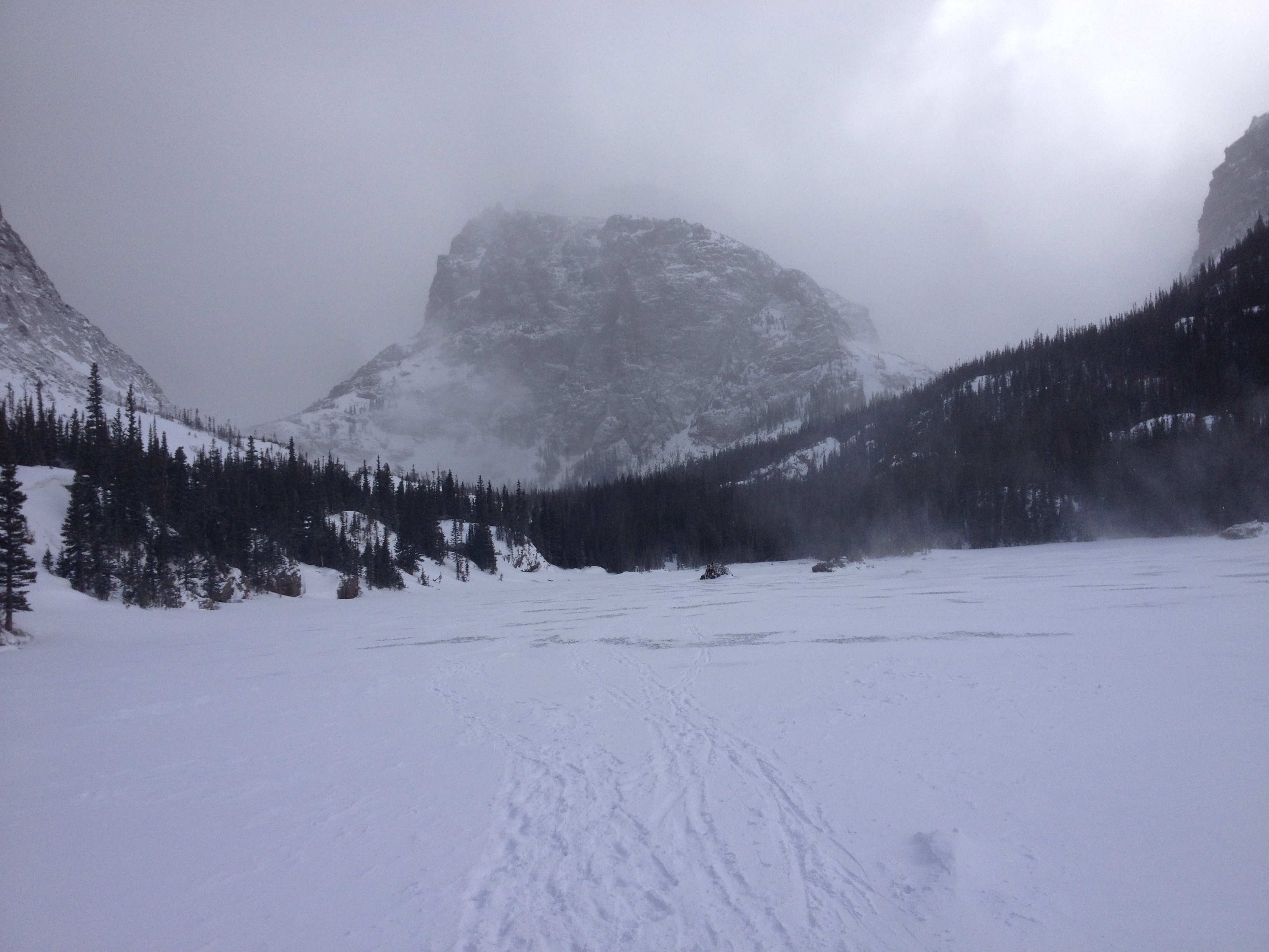
Our first view of Mt Ypsilon and the ‘Aces’ (see the shadows)

We followed the climber’s trail across a good bridge and for another 30 feet before completely losing all sign of a trail.  We continued hoping to find a trail, but willing to bushwack our way eastward, moving up or down depending on the obstacles. I was looking for a talus field that was supposed to mark Rossiter’s ‘grassy gully’ that led to the start of the ridge. In the dark, the talus field we found 1/2 way around looked more like landslide debris; but we took it.  It was very steep, but it went to the start of Blitzen Ridge, which we reached at 6am.  Still on plan.

But then I realized that I had forgotten to get water at the lake.  Shit.  One liter of water for 12 hours of high altitude exercise = bad day.  I started making an effort to breath through my nose instead of my mouth.

And, under the circumstances, I was glad to finally find the cooler temperatures and higher winds above treeline.

Position 5

It was still too dark to see any landmarks, but my GPS confirmed that we were on course.  The next step was to follow the ridge as it turns from a rounded hill to a sharp-edged ridge.  When we reached a point were we could see the Spectacle Lakes, the sun had come up enough to expose the scenery. Mt Ypsilon’s Y-Couloir and accompanying Donner and Blitzen Ridges are wildly spectacular; in my opinion, the area rivals Longs Peak, my favorite mountain in the world.

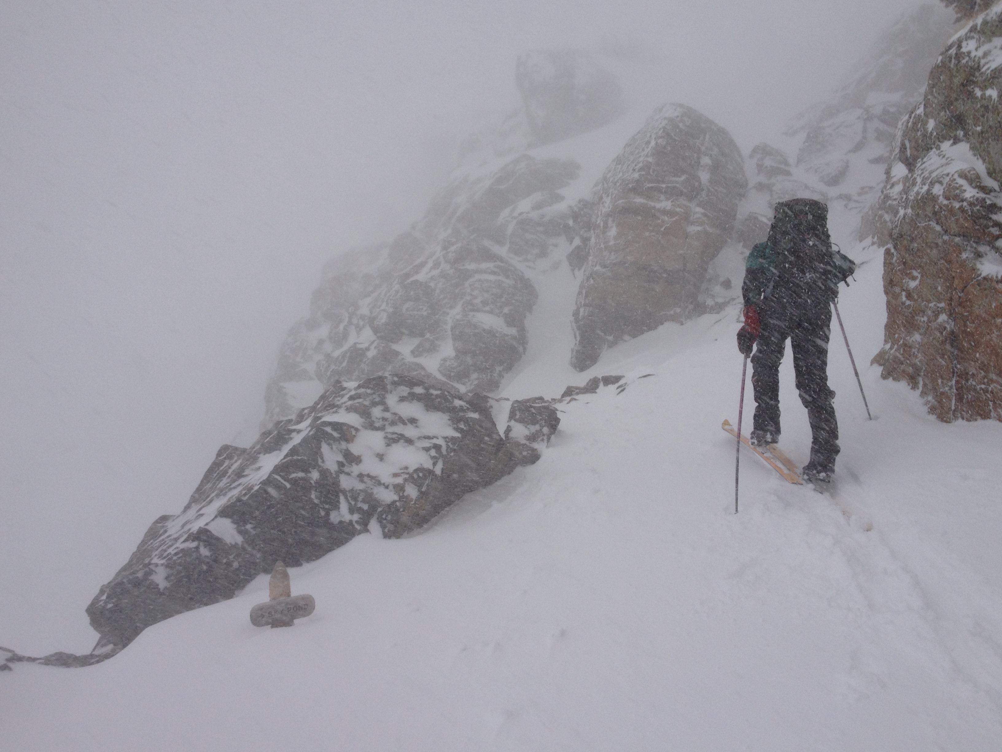
Brian examining the long way up Blitzen Ridge

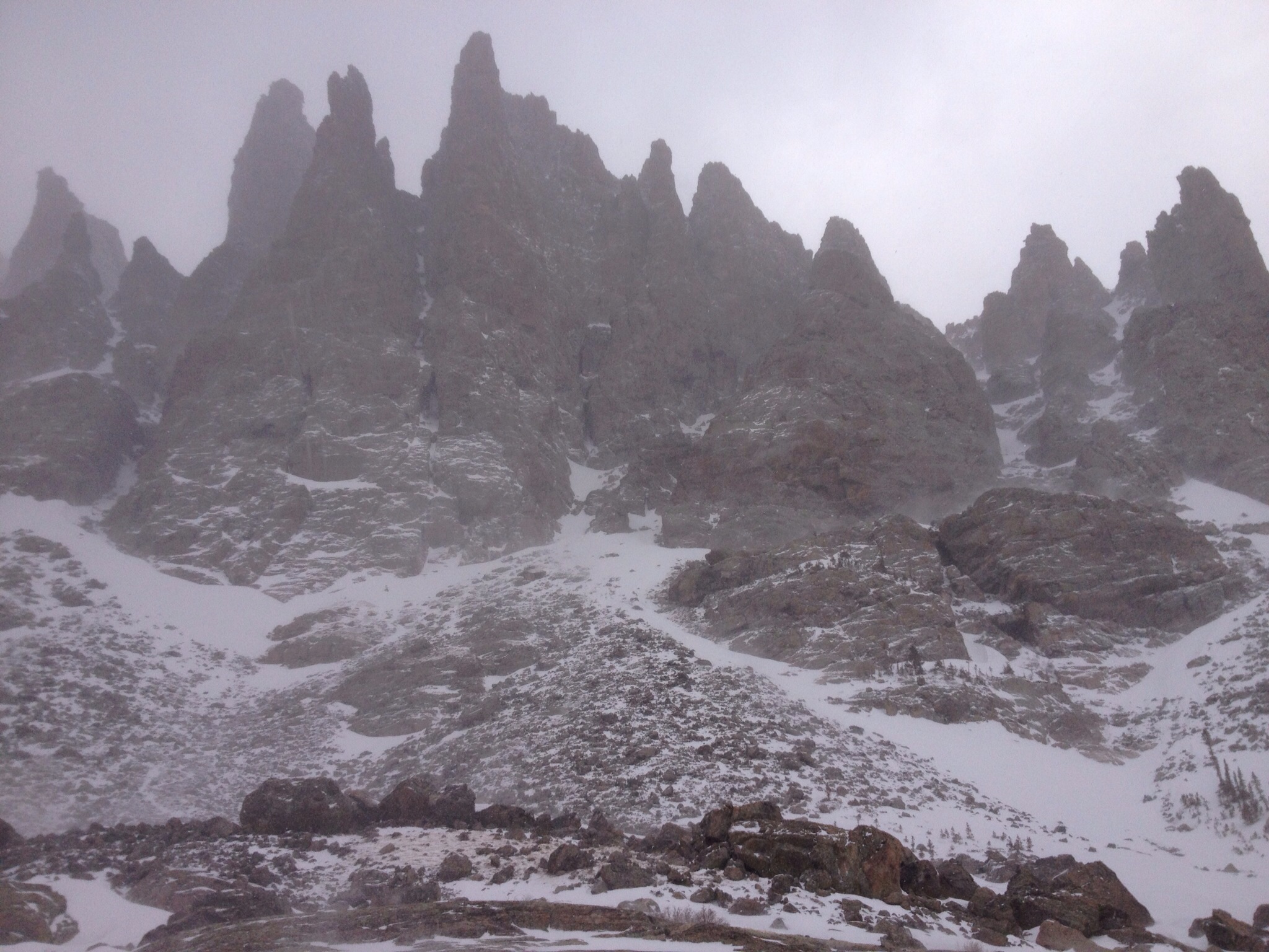
The only odd thing was that we couldn’t see the Aces on the ridge.  Eventually, we saw the shadows of the Aces on the Donner Ridge wall, highlighted by the morning sun. By 7am, we arrived at the base of the 1st Ace; it was an impressive pinnacle.  To climb to the top of it would be a time-consuming undertaking.

Position 6

Our plan was to skirt the 1st two Aces. I took the 1st lead and did a descending traverse on 3rd and 4th class terrain to get below the 1st Ace and then continued with an ascending traverse over somewhat easier terrain to get by the 2nd Ace and to the base of the 3rd Ace.

Brian followed, arriving at 8am, and then prepared for his climb of the 3rd Ace.

Position 7

Brian’s lead of the 3rd Ace

The 3rd Ace was the one we had to climb, according to the route beta.  Brian, delighted for a chance at some real climbing, worked his way up the 3rd Ace, taking the hardest path when possible.

When I followed, the route felt a bit harder than 5.4, but that made sense.

When I arrived at the top, Brian indicated that he couldn’t find a rappel anchor. Now that was a bother, as we brought two ropes specifically for the 2-rope rappel off the 3rd Ace.

I climbed out to the ridge edge to see if I could find an anchor or a place to set one without leaving iron behind; I couldn’t. The going was easy enough that I shouted to Brian that I was going to down climb and place gear to protect his down climb. I admit it would have been better if I had taken the rack; I only had the 5-6 pieces I cleaned from Brian’s lead.

I continued down until running out of rope, but I could see it was going to work. Brian followed and then we scrambled the rest of the way to the saddle between the 3rd and 4th Ace.

Position 8

The plan for the 4th Ace was to pass it on the right.  I had read that the best path comes of climbing up for a bit before turning right.  Looking at the 4th Ace from high on the 3rd Ace, I couldn’t make sense of this advice; and worse, the rock looked hard to climb. But once up close, the obvious weakness in the rock started up and right, right off the ground. It was my lead so I started up, following the slight ramp to see where it would lead.

The climbing was easy but the protection was scarce. I worked far enough right to see a probable path around the corner about 50 feet away.  And then Brian yelled out that I only had 20 feet of rope left.  Shit.

I brought Brian over and then he finished the climb by turning the corner to find a nice walking and scrambling path to the foot of the Headwall. He brought me over and then we scrambled to the Headwall, which would be Brian’s lead.

And then I forgot to look for the brass plate marking Louis Raymond Leving’s grave.  Oh well, I guess it will wait for me.

The Blitzen Ridge ‘Headwall’

Position 9

Brian indicated that he’d read that climbing the white pillar was the best start to the Headwall.  I didn’t think he meant ‘easiest’…he didn’t.

Brian’s lead up the Headwall 1st pitch

He started up the SE corner and found the hardest climbing of the day.  It was a balancey climb in a strong wind. I was surprised to be able to make it without a fall; I’m sure Brian was pleased with himself.

But we had another 125 feet of steep rock to reach the top of the Headwall.  I ran the rope out 75 feet up some 4th class rock and then led a 50-foot pitch to reach the top of the Headwall near a notch in the ridge. Brian came up and then we unroped, based on the advice we’d read (but absolutely not based on the look of the rock).

Position 10

The first 50 feet or so were wickedly exposed, but the rock was good.  The key was to get to the top of the ridge as quickly as possible. Once on the ridge, the difficulty was primarily past.  It was mostly 2nd & 3rd class movement; the hardest part was avoiding the overhanging rocks just out of sight that jumped out to bash my helmet at any moment of weakness.

The last 100 feet was the easiest terrain since before the Aces.

Position 11

Ypsilon summit: enjoying our first break after 10 hours of hiking and climbing

I reached the summit at 1:30pm and sat down for my first official break of the day. I had saved 1/3 liter of water for my lunch. I was surprised that I didn’t feel dehydrated, but it had not been a hot day (so far, I should have realized).

I found Brian trying to use the sun to melt some found ice into his water bottle.  We sat and chatted about the day; I insisted that the Blitzen Ridge was a great idea.

Brian asked if we were behind schedule; he thought I had mentioned a plan to summit at noon. The weather had been so good all day that I didn’t pay any attention to the time.  I dug out my trip plan and found that our 7 hour climb was the high-end of my predicted range (5-7 hours).   We decided to stay awhile and enjoy the views.

I claimed that we could have gone faster if we hadn’t tried to make the technical climbing portions interesting. I was probably right, but it was all good. A good climb and a good plan.

After a 30 minute break, it was time to head down; but not before stopping to appreciate our path over the many obstacles on the Blitzen Ridge.

Position 12

I had a mind to find the best compromise between shortest line between two points and avoiding losing any altitude that I’d have to re-climb. I followed a cairned path much of the way as I bypassed Chiquita and aimed for the saddle between Chiquita and Chapin, finding and losing the path at least a dozen times.

Brian had the energy to bag Chiquita on the way past.  I skipped it since I had already done these peaks on my Mummy Range Weekend adventure some years ago.

Once at the saddle, the trail became excellent and we made good time back to Chapin Pass, finally seeing other people for the first time in the day.  But it finally started getting hot, and I started feeling thirsty.  I wished I had stashed some water in Brian’s truck; now I’d have to wait for the long ride through RMNP.

As we approached the trailhead, the sight of Brian’s truck (13 hours after leaving it) was a sight for sore feet.

We made it.

Panorama of descent path to Chapin Pass trailhead

All that was left was the drive back to my 4Runner at the Lawn Lake trailhead.  Naturally, the traffic was horrific with all the tourists gawking at the aliens dressed as elk.  But, as a mere passenger, I was permitted to sleep and catchup on the lost sleep of the night before (I only got 2 hours of sleep: 10pm to midnight).

And once back at my vehicle, I started home immediately, and I drank 2 liter of water as I drove home.

Another great trip.

Trip data (click for more details)

See all trip reports

See RMNP trip reports

Solitude Lake Cirque

July 6, 2010

A low altitude illustration of the 'off-trail' ascending and descending required to complete the 'Solitude Lake Cirque'.

It was finally time to do it. After many years of thinking about the various connected pieces, it was time to attempt the entire Solitude Lake Cirque: a climb of Arrowhead (3rd or 4th class) from Solitude Lake, then traversing to and climbing McHenrys’ NE Arete (4th Class) to the summit, then traversing McHenrys’ Notch (5th class downclimb and 2nd class scramble) to reach the summit of Mt Powell, and then traversing and downclimbing Mt Powell’s entire NE Ridge (4th class) to the summit of Thatchtop.

We knew it would be a long day.  Even if everything worked out perfectly, it would be a grueling, body-breaking day: over 13 hours, 11.5 miles, and 5140′ of elevation gain & loss, with much of it being off trail. For illustration purposes, the planned effort is similar to scrambling up and down the 3rd Flatiron five times in a row with a mouth-full of water (to simulate high altitude oxygen availability).  Fun, right?

The Solitude Lake Cirque objective and plan evolved over the last 13 years:

  1. The ‘McHenrys Notch’ piece: I learned of ‘The Notch’ when sitting on top of Flattop during the summer of 1997 and wondering out loud about hiking the Continental Divide to Chiefs Head. Brian notified me that ‘The Notch‘ was a challenging obstacle. I was intrigued.
  2. The ‘NE Arete of McHenrys’ piece:  I still vividly remember looking up the NE Arete of McHenrys while sitting on the summit of Arrowhead in 1999 and thinking that it was the most spectacular sight I’d ever seen; I also thought it looked way too scary to to climb unroped (only 4th class).
  3. The ‘NE Ridge of Powell’ piece: I climbed this ridge almost exactly 11 years earlier in a solo effort; it was a near disastrous day as a late start and rainy weather nearly ended my climbing days (and every other kind as well). While my ability to do it while wet was confidence inspiring, the experience was psychologically traumatic.  Brian and I attempted to repeat it in late 2005 but were turned back by heavy snowfall.
  4. The ‘Do Them All Together’ Goal:  in early 2010, I informed Brian that the ‘Solitude Lake Cirque‘ was a goal for the 2010 summer.
  5. The Plan:  during the last week of June, I decided that we’d do the climb clockwise.  Even though The Notch is easier to climb than descend, I worried that a descent of McHenrys NE Arete would be too hard (since I didn’t know the terrain at all); and I thought we’d could rappel ‘The Notch’ if necessary.  And, I didn’t think a down climb of Powell’s NE Ridge would be much harder than an ascent since the elevation change was small. I was very wrong about this last point.

The 'Solitude Lake Cirque' -- illustrative route

And, throwing a monkey wrench into the works, the weather report was not perfect.  A “20% chance of rain after 1pm” was very worrying since it meant the rain would come while we were on Powell’s NE Ridge.  Given my history with that chunk of rock, I was justifiably worried. In addition, the weekend before a forecast of only 10% chance of rain after 1pm came 100% true on a climb of Spearhead in RMNP; I just couldn’t ignore the threat. However, Brian and I worked it out that we could summit Thatchtop by 1pm, if we started @ 4am and moved at a quick pace. That was somewhat reassuring, but I wondered how long we could keep up such a pace.

For better or worse, the ‘Solitude Lake Cirque‘ was a go!

On the morning of July 3rd, 2010, Brian and I left Boulder@ 2:30am for the Glacier Gorge trailhead in Rocky Mountain National Park. Unlike the previous week, the sky was mostly clear; it was a good sign on a day when good weather might be required to survive.

Ascending toward Solitude Lake with Arrowhead in background

I was driving, so we arrived at the trailhead a bit earlier than planned.  We started hiking at 3:45am.

Looking back down the steep hike up toward Shelf & Solitude Lakes

We took the ‘Knobs‘ shortcut to save 1/2 mile, and then took the Black Lake fork off the Loch Vale trail.

Position 1 (see references on map)

About 3.5 miles in, we reached the avalanche gully which marked the cutoff for Solitude Lake.  We turned toward Glacier Creek, gingerly walked along fallen logs to avoid sloshing through the marshy terrain.  A quick hop across the creek and then we scrambled up the steep slope to reach the Shelf Lake area, swatting mosquitoes all the way up.  On one of the longest days of the year (daylight-wise), it was light enough that we could have started hiking 30 minutes earlier.

It was Brian’s turn to dunk a boot, this time working across the Shelf Lake outlet.  But Brian was smart enough to wax his boots, so no wet foot for Brian (unlike my experience on Spearhead the week before).

Nearing Arrowhead, our 1st objective

Position 2

We reached the edge of Solitude Lake at 6:15am; I was delighted with our quick pace.  I thought we would be close to my goal of a 7am Arrowhead summit.  But clearly I had forgotten about the long talus-hop needed to reach the base of the Arrowhead climb.

Our route up Arrowhead

It took us another 45 minutes to reach the base of the climb.

Position 3

We started up a 4th class path Brian picked out; he didn’t want to use the 3rd class route we’d used before. I figured it would be a good warm up for climbing to come later in the day.  Rather than angle directly for the Arrowhead summit, I decided to climb to the ridgeline first.  I was rewarded with spectacular views of Glacier Gorge through the clear, early morning air.

Position 4

Joe (me) on Arrowhead summit with McHenrys NE Arete in background

I then joined Brian on the summit of Arrowhead at 8am.  We were already one hour behind schedule. It was time to start going faster, somehow.

The weather looked good, but we could see the winds above McHenry were moving very quickly.

Looking back down the NE Arete toward Arrowhead

We started back down the ridge toward the saddle, and then up the NE Arete. The climbing was not very difficult; there were a few spots of harder climbing below the Gendarmes on the ridge.  I was pleasantly surprised to find that the climbing was nearly all 3rd class, with only a spot or two of 4th class. Accordingly, our time was pretty good, even though I was slowing down a bit after over 4300′ of elevation gain in the last 5+ hours.

The finish was remarkably easy and led to within a few yards of the summit.  A great route.

Position 5

Joe (me) on McHenrys summit with Longs and Chiefs Head in the distance.

We reached McHenrys summit at 9:30am; still one hour behind schedule, but at least no further time was lost. And the wind was cold and strong.

After a short break, we started toward The Notch.

Brian hiking toward 'The Notch' with Powell in background

Progress was easy for a while, but then became confusing. It was unclear which ledge was the correct ledge to take to the downclimb.  We decided to stay on the ridge crest as long as possible, which forced us to make an exposed move or two to reach the end.  From that position, we could see that the ledge below us had been the correct ledge; we downclimbed to it and then traversed over to the gully that led directly to the top of ‘The Notch‘.

Brian put on his rock shoes (removing Makalus); this says it all.  It was steep.  Plus, the freezing wind rushing up the gully was enough to unnerve anyone.

Brian descending the last few feet of the gully toward 'The Notch'

At first, the downclimb felt very hard; but that was just me getting used to the awkward nature of downclimbing steep terrain. The holds were good and we made good time for a bit. After about 100 feet, Brian found a rappel anchor and thought we should do a belayed downclimb. I was thinking we were past the hard part, but I rarely argue for less protection.  Brian was right. The next 150 feet was harder.

A view of the ascent path out of 'The Notch' to reach the summit of Mt Powell

We had brought a small rack, so it took some doing to put in gear for Brian’s protection.  And we were both freezing in the wind.

Position 6

I reached the bottom of the gully at 10:45am and worked my way into the sunshine before stopping to give Brian a belay. He came down quickly and joined me in the sunshine to warm up. The downclimbing was good due to the solid hand holds; it was a luxury we would miss later in the day while downclimbing slabs.

A view of the spectacular Mt Alice seen from 'The Notch'

We wandered over to the edge of The Notch to have a look and also gathered in some great views of Powell Lake and Mt Alice.

We also marveled at the great looking rock marking the Powell edge of The Notch; still, we were happy to have an alternative to escape The Notch.

Brian led the way down The Notch to reach the gully we could ascend to reach the top of Mt Powell.

Brian taking the final few steps to Mt Powell's summit

On the way up, I was delighted to find a trickle of snow-melt running over a rock that I could use to refill my empty water bottle.  I was very worried about not having more water for the rest of the day; it was only 11am. I silently wished for 2 bottles to fill.

Brian moved ahead and I followed as soon as my full bottle was put away. The gully was a bit loose, but not too bad; a mere 2nd class scramble.

Position 7

Looking back at McHenry from the summit of Powell, with Longs and Chiefs Head in the background.

We reached the summit of Mt Powell at 11:30am; we had picked up 30 minutes against our schedule and were now only 30 minutes behind schedule.  And 3 peaks down; only 1 more to go!

I realized that I had never been on the summit before.  The time I thought I had summited, on my trip up the NE Ridge from Thatchtop in the rain, I must have stopped at the false summit some yards to the north.  Well, better late than never.

And, now I was feeling very confident.  While the weather was getting worse, it looked like it would hold out until 1pm….just a few dark clouds so far. We didn’t even have to discuss our plan B of descending Andrews Glacier. I was thinking, ‘how long could it take to complete the NE Ridge’?  The reports of the ridge taking 4 hours seemed ridiculous.

Position 8

A view of the Cathedral Peaks and Sky Pond

We hiked toward Mt Taylor for about 200 feet and found a keyhole to slide through to get onto Powell’s NE Ridge. We then had to navigate a few feet of snow to reach the climbing, but that was the only snow we had to contend with all day.

Position 9

Finally, the only real hurdle remaining was the crux section of the NE Ridge; the section that I struggled so terribly with all those years ago. If we got past that section of the ridge, we would certainly make it. If the rain came before, we’d have to rope up if not turn back for Andrews Glacier. But the remaining hour before 1pm would surely be enough, wouldn’t it?

Brian working down the steep slabs on Powell's NE Ridge

I had budgeted 2 hours to do the entire NE Ridge; it took us 2 hours to just to finish the hard section.

Brian working past the crux

I was utterly wrong about how long it would take to complete the ridge. Descending 4th class slabs is much harder than ascending them.  Much harder….even when the altitude loss is minor. My mistake was due to my lack of understanding or appreciation of 2 factors:

  1. Descending 4th class slabs is complicated by the complexity of route-finding as holds are obscured when viewed from above
  2. Descending 4th class slabs is much harder at the end of a long day than seems possible at the beginning of the day

Brian nearing the end of the hard part of Powell's NE Ridge

Fortunately, the weather stayed dry.  The wind was unnerving as it tossed us around while we smeared our way across and down the slabs, but at least the rock was good for sticky rubber.

Position 10

Once past the hard section, I told Brian that I had followed the ridgeline all those years ago (which is also Roach’s instructions; I checked).  Brian said he liked the look of  the talus below the ridgeline. I wondered if there was a reason for Roach’s advice and so I angled up to the ridge near Point 12836 to see if the ridgeline was a better path.  Instead, I found the ridge was much harder than the talus below, so I descend to match Brian’s path.

A tired Brian sitting below the summit of Thatchtop

At a little before 2pm (and the weather still holding), I found Brian resting below the summit of Thatchtop. In his green jacket, I couldn’t see him until I was within rock throwing distance. He looked so comfortable, I couldn’t resist the temptation, and so I stretched out on a grassy patch.  It turned out that he wasn’t comfortable so much as sleepy.

Resting my feet on Powell's NE Ridge while enjoying the flowers

I finished my water and ate a snack, and I remarked to Brian that I would be willing to pay a lot to have the truck close-by.  The thought of descending thousands of feet and multiple miles just shriveled my morale.

All I had left to comfort me were my own words of advice: the greater the suffering, the greater the feeling of accomplishment.

Misery Axiom: never turn back because of mental misery.  More mental suffering (e.g., boredom, frustration, irritation) leads to more personal rewards, which can only be harvested through perseverance (corollary to Reward Rule).

Reward Rule: personal rewards are maximized by seeking an aggressive goal that matches the most optimistic assessment of your willingness to suffer; the right goal allows both success and satisfaction

Position 11

But we had many miles to go, as it has been said before.  We trudged up to the summit of Thatchtop, and I stopped for a photo of our day’s route.

The 'Solitude Lake Cirque' route overview

Brian hadn’t stopped, so I hurried after him, working my way down the endless talus field.  It was another mile of talus hoping to reach the bottom of Thatchtop. And at the end of such a long day, it was an endless misery.

Brian later pointed out:

Thatchtop’s name is appropriate from a long distance, but becomes supremely aggravating when one is actually on it and trying to hike over the ‘thatch’.

So true, Brian.

Brian heading down Thatchtop

And that wasn’t the end.  We still had to find the descent gully, which somehow eluded us.  After wandering through the peculiar stunted forested area at the end of the ridge, we finally stumbled upon the gully.  The gully turned out to be far more loose than I recalled; we slipped and slid down and around the corner before finally escaping.

And that wasn’t the end either.  We still had to work our way down the mixed forest/talus field to reach the creek flowing from Loch Vale.

Statistics for the 'Solitude Lake Cirque'

It was a level of effort I was not prepared to expend.  I was really beat.

I don’t think I’ve ever done so much off-trail descending.  To get down, we had to descend over 4000′ down talus and technical rock.  Try hiking down Longs Peak without using any trails..

And still we had to hike another 30 minutes to reach the car.

What a day!  I’m glad we did it. I’m glad it’s over.

Our route on the 'Solitude Lake Cirque'

See all trip reports

See all RMNP trip reports

Interesting info regarding ‘Cirque de la Solitude’ on the ‘toughest long distance trail in Europe’

Unnamed (and Mt Antero)

June 10, 2010

May 27, 2000

With Memorial holiday giving us an extra day I was hoping for a bigger than normal adventure…but Brian couldn’t pull off two nights out. We had to make do with a single day with an early start.

Brian suggested Antero, with the idea that we could get a good ski descent. Since Antero was one of the few unclimbed Northern Colorado 14ers on my list, I loved the idea.

The drive up, which started late due to my tardy arrival, was interrupted by a missed highway turnoff and an accident that closed the highway for an hour. To make use of the time and avoid eating dinner after midnight, we got out the stove and made dinner on the side of the road. And, it still might have turned out okay, except the approach road was very long and slow going. We made it to 11,300′ before stopping to setup camp; we settled in for sleep at 1am. With a 5am wakeup call forthcoming, it would be a short night.

Brian on final approach to Mt Antero summit

We started moving at 5:30am and took 3 hours to ascend from camp at 11,300′ to the Mt Antero summit at 14,269′. We followed the winding road up, but didn’t trust where it led after passing the summit ridge; we followed the ridge to the summit. Unfortunately, we also discovered that there wasn’t any snow left on Antero except for a thin strip about 50 feet wide and 500 feet tall on the southern ridge leading to the summit.

We enjoyed the summit for a short time and discussed our options for the day.

My rapture on the summit of Mt Antero

Since we couldn’t get our ski descent, we decided we’d head over to a tall peak across Baldwin Gulch that had a very nice snow covered eastern slope. But we had to hurry since the snow had been in the sun since dawn.

We descended Antero following the old mining road which turned out to lead to the final stretch of the summit ridge.  Once at the start of the switchbacks, we left the mining road and headed around the cirque toward the unnamed peak.

Where's the snow? On the way to some snow on 'Ol Unnamed (North Carbonate?) from Mt Antero (in background).

The progress was good until we got to the exposed scree & talus on the SE ridge of the unnamed peak.  It was murder for tired legs.

We found the summit to be protected by a weird cornice that required crawling over to get to the top of the peak. I needed a rest, but with the sun burning on the snow, we stopped only momentarily before setting off for the steep descent slope.

As we feared, the snow was soft, and possibly dangerous. After a short pow-wow, we decided we’d proceed…with the extra precaution of staying on opposite sides of the face and only skiing one at a time. The snow turned out to be great, and we had a great time descending 1800′ in only a few minutes.

Our route from Baldwin Gulch to Mt Antero and North Carbonate(?)

The hike out was mercifully short; we made it back to camp at 1:30pm for an 8 hour, 8 mile, and 4000′  day.

And sometimes, one day is enough.

In the years afterward, I came to believe that the peak had an unofficial name, “North Carbonate”.  And, just recently, I discovered that the officially unnamed peak got an official name in 2005…it is now called Cronin Peak.

Formerly known as “North Carbonate”, this mountain now has an official name, approved by the Department of Interior in May 2005. Cronin Peak is named in honor of Mary Cronin (1893-1982) who in 1921 became the first woman to climb all the fourteen-thousand foot peaks in Colorado.  ~summitpost

See all trip report

See all 14er trip reports

Mt Evans Extreme

June 2, 2010

It was the end of May, 1999, and I had just returned from my Great Bolivian Adventure. I didn’t have time for a full day of mountain fun, and, naturally, Brian wanted to ski; we picked Mt Evans as a good, close-by solution, with the thought of seeking the route less travelled to spice things up. And, I was anxious to see how much better my performance would be with my Bolivian, high-altitude acclimatization.

A view of Mt Evans and the rocky ridge separating Mt Evans from Mt Spalding

We drove up early to get good snow conditions and parked in the parking lot beside Summit Lake. We started working our way forward, postholing our way to the top of the bowl rim so we could get a good view of the options. We decided to angle right toward the rocky face dividing Mt Evans from Mt Spalding, aiming for the snow slope that reached nearly to the top of the ridge.

Brian nearing the exposed rock portion of the climb. The hard snow climbing occurred just before this spot.

Brian picked it, and I went along; I thought it looked interesting and possibly climbable. I forgot that we didn’t bring a rope; read: no belay.

The climb started like any other moderate snow climb, but about 2/3rds of the way up it got hard; the route became steep over mixed terrain.  And I was huffing and puffing with poorly functioning lungs. I whined to Brian that my allergies were acting up and trying to suffocate me.

The last 50 feet was thinly covered rocks; very little for the crampons and nothing for the axe to grab onto. On two separate occasions I had to commit to moves that I expected to fail, when failure meant some very bad outcomes. My alternative was to stay there for the rest of my life. The worst was at the very top, which turned into a moderate rock climb with crampons and ice axe making every effort to kill me.

I didn’t get a belay, but I recall Brian was generous with his words of encouragement.

But we made it to the top of the rim.  Thanks, Pal!

Then we hiked to the summit and enjoyed the well earned views. My breathing was so labored that I swore to Brian that if Colorado made my allergies this bad again, I was moving!  The skies had quickly changed from beautiful blue to looking like rain or snow soon, but we didn’t start down for the North Face until the axes started singing their dreaded electrical song.

We got down well enough. My glissade wasn’t very good due to operator error; I guess I just forget how to do it, having been skiing instead for the last year. Some additional huffing and puffing while postholing had me really annoyed with my physical performance. I had looked forward to kicking Brian’s butt for a change, but my 20,000′ plus acclimatization just didn’t pay off the way I expected.

Brian about to descend the North Face to escape the electrical field around us.

Twenty-four hours later, I knew why:  I had the flu. Isn’t air travel just lovely? At least I could continue living in Colorado with a clean health conscience.

It was my 3rd summit of Mt Evans, and the most interesting so far.

See all trip reports

See all 14er trip reports

Huron, Bloody Huron

May 28, 2010

Our drive, hike & climb to Huron Peak summit

One more time. Brian and I thought we’d back to the Clear Creek Reservoir Road, this time to collect Mt Huron. We knew going in that it would be a 10+ mile hike in the snow with a 4000′ elevation gain due to the winter road closure, but we were on a roll and Huron was next on the list. The only problem would be the inevitable snow storm; the previous week it snowed all the night before. And, it did so again.

It was Brian’s turn to drive; we left his place in Golden @ 7:45pm on Friday (April, 23, 1999) heading toward Leadville.  The Bronco is a slow beast, but it works wonders on poor backcountry roads. Along the way, we were pleasantly surprised to find the roads in better shape than the previous week (when we did Missouri Mountain) despite the heavy new snow in the front range. We figured we’d gotten lucky on the snow distribution.

Brian picked the East Slopes route. At the time I figured it was the worst thing he could find, but in hindsight I suppose it might have been because Dawson wrote that the East Slopes generally have more snow. Well, we did have plenty of snow.

Aiming for the Clohesy Lake trailhead, we pulled off US Highway 24 onto Clear Creek Reservoir (dirt) Road. We immediately knew we had been mistaken about getting lucky with the snow; the accumulation was much worse than the previous week.  We drove past our previous camp at Vicksburg and to the Rockdale townsite where we turned onto the 4×4 road heading toward Clohesy Lake trailhead, but only managed to get 1/3 mile up the 3-mile road before the snow was too deep to drive even for the Bronco.  And, believe me, that means something. A determined Brian forced his way cross Clear Creek before giving up on the drive; that crossing was much more interesting than I like at 11:30pm.

We setup camp as quickly as frozen fingers allowed. And then sleep came quickly, and so did 5am.

The first thing we noticed was the temperature.  It was way too warm.  Crap, it was going to be a hellish, soft snow day.

The initial hiking over the 2.7 miles remaining of the 4×4 road was rather flat; we started at 10,000′ and took 1.5 hours to gain 800′ of elevation. I hoped in vain that it would be a nice downhill glide 10 hours hence. Still, it was an easy start, for me anyway. Brian broke trail; and for a change, he actually made a trail I could use instead of gliding across the surface like a modern day Legolas. It was odd to hear him grumble.

Once we cleared the treeline, we could see heavy snow covering the ridges descending from Huron.  It was still early and already a slide had occurred, nearly reaching our ascent path.  We kept our distance from the snowy slopes as best we could, and we tried to hurry to minimize our exposure.  But it was a long curving path to reach the couloir ascent to the summit ridge.

Detail on the final stretch to the summit

The final couloir was very steep and icy. So, we didn’t have to fear an avalanche, but the skins were only marginally up to the task of ascending such a steep, slick surface. We slowly worked our way up until about 3/4ths of the way up we had to exit into the rocks on the right to make the saddle.  The climb certainly would have been better with crampons and an axe.

The weather had looked bad all day and continued to do so.  We tried to hurry to the summit, but the snow on the ridge was too soft. I literally had to swim across the sections without rocks to step on. This misery was compounded by my agreeing to bring the skis to the summit, where we sat for only as long as it took to eat a quick snack.

I carried the skis up to the summit and then carried them back down to just above the saddle.  When I dared put them back on, the snow stuck to the base like tar.

Fortunately, by the time we reached the top of the couloir, the skiing returned to a normal state for the day…merely terrible. A few turns into the descent, I hit a rough, icy section and lost it. I hit face first and cartwheeled down the slope, bashing my brains in on every flip. My self-arrest ski poles allowed me to stop after a few flips, but not before mutilating my nose. And this only 2 weeks since making a pact with God to take better care of my nose after allowing me to keep most of it after some frostbite on a cold, windy day on Mt Silverheels.

I bled continually and fell frequently as I attempted to escape Huron with my life and the remainder of my health (and nose).

Once we made it past the lake and reached the 4×4 parking area, the snow had softened enough to become impossible. In the last 3 miles, I fell through the snow 6 times. One time I could not get back up; it was a sort of quicksnow. I finally had to resort to rolling to escape the pit I dug for myself.

We made it back to camp at 6pm for an 11.5 hour day covering 4000′ of elevation gain and 10+ miles of soft snow slogging.  And, I was a bloody mess.

Some trips it is hard to remember that I do this because I love it; but it is important that I remember it.

See all trip reports

See all 14er trip reports


%d bloggers like this: