Posts Tagged ‘kieners’

The Long Way Up Longs Peak (Stettners-Kieners)

February 3, 2010

I love Longs Peak, and one of my unofficial missions is to climb a different route/season combination nearly every time I reach for the summit.

Next on the list was to reclimb the route used by the Stettner brothers (Joe & Paul) to climb Longs Peak on September 14, 1927, including the Stettner’s Ledges (5.8) route to climb from Mills Glacier to Broadway Ledge.  As they did, we’d also use the Kiener’s Route (5.3) to skirt the difficulties of the Diamond and reach the summit. Stettner’s Ledges represented the hardest multi-pitch alpine route in Colorado (and perhaps in North America) for the subsequent 20 years.

“We were familiar with two established climbing routes on the East Wall — Kieners and Alexanders. We studied them. But we wanted to find a new route. We searched for a route by starting at Alexanders Chimney and working our way to the right with the binoculars. With the help of these field glasses, we found a line of broken plates, ledges, and cracks that we could eventually use as a route. It looked challenging enough for us.”

~ Joe Stettner’s Journal, recounting the events of September 14, 1927

On the morning of July 17, 1999, Brian and I started up the the trail towards Long Peak, passing the Longs Peak Ranger Station @ 4:15am.  It would be my 6th different route to the summit of Longs Peak, if everything worked out.  The only thing I worried about was the weather report; we’d have to get lucky to reach the summit on this day.

My Routes (prior to 7/99) to the Longs Peak Summit

  1. The Diamond, Casual Route (7/94)
  2. Notch Route (6/96)
  3. Keyhole Route (11/96)
  4. Kiener’s Route (7/98)
  5. Gorrell’s Traverse with a direct finish of The Notch (9/98)

The hike in went as so many have gone before it….long but tolerable.  And, despite a serious attempt by a slippery trail to destroy my knee, we maintained a good pace and reached the foot of the climb by 7am.  I somehow managed to forget that Mills Glacier would be hard snow and didn’t bring anything to aid my ascent of the glacier/snow field to reach the start of the Stettner’s Ledges climb.

Stettner Brothers 1927 (dashed) & Joe/Brian 1999 (solid) Summit Routes

Aiming for the bottom of the obvious left leaning flake system, I used my nut tool as a make-shift ice axe and kicked steps when I could and otherwise crawled to ascend the shockingly steep Mills Glacier.  During this ridiculous episode, I stole a moment every now and again to think how this was a really stupid way to ruin a day, a season, or worse.  My relief was palpable when I finally reached solid protection from a long slide to the bottom of  Mills Glacier.

Looking back on our approach around Chasm View Lake

Stettner’s Ledges

1st Pitch

Brian took the first pitch.  It was a 140-150′ long climb angling somewhat left over many flakes and cracks with a few pitons to guide the way.  He found a nice ledge for our belay.

2nd Pitch

I took the second pitch that started with a step around a corner and involved easy climbing over some blocks to reach a good belay at a right facing large flake (5.5).

3rd Pitch

Looking up, we could see a series of pitons jammed into an overhanging dihedral protecting a steep climb over thin holds navigating a robust layer of slime.  The water trickling down from The Notch was feeding an aquatic ecosystem that looked like it would be protected by Boulder’s Open Space & Mountain Parks organization if located a few miles further east.  I tried to help Brian’s psyche by suggesting he could aid the climb if it was as bad as it looked.  Right.

Brian on Stettner's Ledges

Not one for delaying the inevitable or waiting for government intervention, Brian took off to figure it out (in proper Paul Stettner fashion).  After a moment of sitting, I noticed that the sun was gone; I was stuck in the shadows and my body temperature was dropping quickly.

I got small to preserve my body heat while I waited for Brian to swim up to the next belay and free me from my static duties.  The conditions demanded a slow climb, but my suffering was all out of proportion to the hour it took for Brian to finish.

Climbers Rule of Variable Time Passage

“The rate at which time passes for a climber is directly proportional to the level of preoccupation for the climber and inversely proportional to the level of suffering and pain endured by the climber. “

And to make matter harder to endure, it was during this pitch that the rockfall barrage begain.  I don’t know if it was climbers (I think it was although no one yelled, “rock” ) or merely natural falling rock from freeze/thaw action (the Stettner brother wrote of rock fall here in 1927), but it was damned unnerving to have such volume of rock crashing down the rock within 10 – 20 feet of my head.

When it was my turn to climb, I was so stiff and my hands so useless I didn’t think I could climb the 3rd Flatiron.  But the body can warm up quickly when the stress is right.  I followed Brian’s path through the slimy ecosystem, taking huge sections of it with me on my clothing.  When I reached Brian, I could see he had taken a hit to his nose somehow.  It was now a “blood” adventure.

4th Pitch

I traversed left onto the Lunch Ledge after mounting a steep flake system which felt harder than the rated 5.5.  When I reached the end of the “Lunch Ledge”, it was obvious that we needed to make a team decision about how to proceed.

5th Pitch

I brought Brian up and then we took a few minutes to look for the direct line (Hornsby Direct variation).  The rock was very confusing, and we just couldn’t spot the correct path out of the many options above us.  We reasoned that we needed to hurry given the weather report and our plan to continue to the summit. We decided to find the easiest, quickest path to Broadway Ledge: The Alexander Chimney route. (Note:  we also thought that this was the original line of the Stettner brothers, but that has since been refuted; the original line took a direct path, probably the Hornsby variation).

Even still, the path wasn’t obvious.  Brian followed his nose, generally left and up over ledges and around corners.

6th Pitch

The final pitch was mine.  I couldn’t figure out what I was looking for and eventually tried to climb a dihedral that didn’t quite work.  After a downclimb I finally found something that looked like the Alexander’s Chimney finish, but ran out of rope without a belay spot in sight. I waited for Brian to take down the belay and then we simuclimbed the last 40 feet to Broadway Ledge.

It was a struggle, but we made it.  And we did it without falls, but it took us 6.5 hours compared to the Stettner brothers 5 hours.

“With great trouble, we fought our way upwards. Time-wise, it appeared that we would have to retreat.  The wall was approximately 1,600 feet high and, besides being steep, it had many overhanging sections.”

Yet, despite multiple falls held by a hemp rope (static) they bought at the Estes Park General Store (“Though not the best, it ought to fulfill the purpose”) that was merely tied around their waists, the Stettner brothers reached Broadway Ledge after 5 hours of climbing.

~ Joe Stettner’s Journal, recounting the events of September 14, 1927

Traverse to Kieners

We followed the Broadway Ledge to the Notch Couloir, and then to the far edge where we knew at least one variation of the Kiener’s Route that worked.  We were on terrain we knew, but it was late on a day with a threatening weather forecast.  But, with the weather still holding up well, we figured it was better to run up terrain we knew than to try to rappel down to Mills Glacier without a known rap route.  And descending via Lambs Slide was completely out of the questions without crampons and axes.

Kiener’s Route

“Walter Kiener, a climbing guide, pieced together this route in 1924, looking for the easiest way up the east face with an eye toward future clients. Very little new ground was covered on the ascent. It’s possible he did this over several visits, with help from Agnes Vaille and Carl Blaurock. Another guide from this era, Guy C. Caldwell, installed cairns all the way up the route and advertised his services in the Aug 7, 1925 issue of the Estes Park paper”

~ Bernard Gillett, The Climbers Guide: High Peaks, 2nd edition (2001)

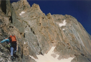
Our Upper Kiener's Route

To save some time, we decided to simul-climb the low 5th class section.

We started straight up through the broken rock and over a chockstone, and then into a narrowing chimney which we took to its end, and, then, up a waterfall to a big, grassy ledge.

Past the 5th class climbing, we unroped to make fast time up the 700 feet of talus and gullies.

We knew from previous experience to aim for the edge of the face and look for the “Black Bands” of rock.  When we finished climbing over the long section of giant steps, we moved to the edge of the Diamond to turn the corner and reach the east talus slopes.

And after scrambling the final 200 feet of talus, we reached the summit at 3:45pm; my 6th Longs Peak summit was in the bag.  We had climbed the 1600′ of elevation between Broadway Ledge and the summit in 1 3/4 hours; its good to see we can pickup the speed if we have to do so.

Our weather luck had held out, but we still had to get down.

Descent

We chose the Cables Route, as always, for its direct approach to the Boulderfield.  The path is easy to follow since we’d done several time before, except this time the path was blocked by a large snow patch covering the last 100 feet above the rappel anchors.

Crap.

Fortunately, this snow had been in the sun all day.  But the terrain was steep enough that it wouldn’t take much of a slip to generate the speed needed for air travel.  We carefully kicked steps and jammed exposed fingers into the snow…anything to get a little friction.  By the time we found the first rap anchor, my fingers were frozen stiff.

Then it started to rain.

Combined with the approaching darkness, we didn’t need any additional encouragement to hurry once again. A quick pace down that death-march trail got us to the Ranger Station by 7:45pm for a 15.5 hour round trip.

The best adventures always include some amount of overcoming or dodging serious setback, such as:

  • A smashed knee
  • Missing ice gear
  • Rock fall
  • A bloody nose
  • A route finding error
  • Threatening weather

And this trip was a great one.

See all Trip Reports

See Longs Peak Massif Ascents

Longs Peak: Kieners’…er, Notch Route

January 18, 2010

Rich (left end) and me (right end) during our Amazon river cruise in 1993.

When I first moved to Colorado in May, 1996, the only person I knew was Rich whom I met on a 1993 Ecuador mountain climbing trip that included a successful climb of Cotopaxi (19,347′) and a failed attempt on Chimborazo (20,560′) as well as a canoe exploration of a tributary of the Amazon river. I only knew him for 3 weeks, but knew him to be an excellent climber and all-around good guy.   And, he welcomed me into town in the best way I know…he invited me to join him on some adventures.

After a “try-out” trip in May, 1996 to bag Horseshoe Mountain (13,989′) and Sheridan Mountain (13,748′), Rich invited me to join him on an attempt at the Kieners route on Longs Peak.  Longs Peak was already my favorite mountain (as it was the first and only 14er I had done), and besides, I was ready to try anything if Rich was willing to let me tag along.  Rich described it as a classic mountaineering route with snow climbing and rock scrambling; I accepted with inappropriately high enthusiasm.

A view of the distant Kieners Route on Longs Peak, with Mt Meeker to the left and Mt Lady Washington to the right. Photo taken on descent.

On June 17, 1996 at 2am, Rich and I left for RMNP and the Longs Peak Ranger Station.  We started up the trail in the dark, and me without a headlamp, I made sure to stay on Rich’s heels to borrow some of his light.  I wasn’t in top mountain climbing shape, but Rich politely kept the pace at a level that I could survive.

We hiked past Chasm Lake as the sun started to come up and then up to Mills Glacier at the base of Longs Peak.  I recognized a few features from my Diamond trip a couple years earlier, but most of it looked unfamiliar.  I was able to spot the Diamond which dominates the east face and the Notch which splits the east face.  According to Rich, the Kieners Route started at the base of the Notch and ascended the south edge of the Diamond.

I was past ready for a break, but we continued up to the base of Lambs Slide before stopping only long enough to put on our crampons and have a bit of water.  The plan was to ascend the Lambs Slide couloir, heading up and south along the lower east face of Longs.

Rich heading toward the Kieners Route (the low angle rock above the steep "Diamond")

I had done several snow climbs before, so I wasn’t nervous in the days leading up to the climb. But this turned out to be an iron climb.  Lambs Slide was hard ice and I rarely got penetration from my flexible crampons. I was wishing fervently for my plastic boots and mentally going over my self-arrest training as I slowly I crept up the couloir, stepping from frozen footprints to rocks protruding from the ice wherever possible.  When the rock face to our right broke up, Rich announced we were at the start of the Broadway Ledge (~13,000′).

The scramble along the ledge was easier than I feared.  I started to think that Kieners was going to be fun after all.  Then we reached a break in the ledge blocked by a protruding boulder. Incredibly, we had to crawl around the protruding boulder with our butts hanging out over an 800′ drop back down to the bottom of Lambs Slide.  Rich saw the look on my face and asked if I’d like a belay. With a gratitude since unmatched, I accepted his offer.

Rich in the distance on the narrowing Broadway Ledge with The Diamond and Chasm View in the distance

Getting past the roadblock was easier than it looked, but I was glad to have that belay.  Once past, we continued working our way along Broadway Ledge, heading toward The Notch and The Diamond. I was disappointed that Broadway Ledge was such a frightening place, with a sloping edge and ball-bearing sized pebbles atop a smooth rock foundation with an 800′ fall rewarding the least error. I couldn’t see how people avoided slipping off with public-outrage-level regularity. But I couldn’t turn back now without re-crossing the ass-overhang.

I caught up with Rich as he stared at the rock face on the far side of the Notch.  He looked over a me and said that the start to the Kieners Route should be here, somewhere. Naturally, I was of no use except for having the sense to keep my mouth shut when I had nothing useful to say. As the official “belay slave” I hadn’t bothered to study the route and wouldn’t know where to begin to look for information anyway.

Rich decided that we’d go higher up the Notch to find a way to get onto the Kieners Route, so up we went.  The  couloir was more snow than hard ice, but it still felt insecure…and now I could fall much farther.  Up and up, we looked and hoped for a solution.  We crawled up much of the Notch before we found an exit to the right.

Looking back down the Notch Couloir

I had no idea where we were; all I could see were giant cliffs on 3-sides and a lot of air on the fourth. But faith is a powerful thing.

Rich led us across a number of gullies with ice and running melt water, one in particular felt like it would be the last thing I ever did. Stepping onto sloping ice with only the spike of my axe on a rock to save my inevitable slip did not seem to be a smart thing to do; but I had to keep moving forward as the day was getting old.

Rich said we needed to traverse back toward the east face to escape the cliffs blocking our access to the summit block. That sounded good to me as I had no notion of being off-route or what getting lost might mean; I was just following Rich.

Once past the icy gullies of death, the going was pretty easy with only a few technical rock sections; at least rock climbing was something I knew how to do.  Rich even let me lead a couple pitches.

Eventually, we reached the edge of the east face.  Rich was studying the rock when I started to remember the path I took during my guided trip up The Diamond.  For lack of a better option, we tried it and found it worked.

A few hundred feet of scrambling up talus led us to the summit of Longs Peak at around 1pm, 9 hours after we started hiking.  It was my 2nd summit of Longs Peak, and only my 2nd time above 14,000′ in Colorado; it felt even more exhilarating than my guided trip up The Diamond.  It felt like we had faced far more risk on our the snowy, icy terrain than I did going up clean rock on The Diamond.

My Longs Peak summit shot

I felt wonderfully satisfied with the day until I remembered that I had to catch a flight in the evening.  I was going to have a very long day.

Without much of a rest, we scrambled down the Keyhole route.  Rich had wanted to do the Cables Route, but we met a fellow on the summit who convinced us that the Keyhole Route would be easier in the snowy conditions.  And I was hungry for the “easier” way; my sense was that I’d used up my good luck and wanted to take no more chances.

But the Keyhole Route was no cakewalk.  Ice covered the Homestretch; the Narrows was a bad surprise (I had never done the Keyhole Route); the Trough was unpleasantly loose.  It took 2 hours to reach the Keyhole, and to think I just had to do 2 rappels to get down the Cables Route.

Rule of Rational Skepticism:

Do not believe anything or anyone on the trail without sufficient reason to do so

Once we reached that little rock shelter near the Keyhole, we stopped for the last of our water.  I also checked my voicemail to see if anyone from work was looking for me; it was a relief to find no voicemails, especially from my boss wondering why I was no where to be found.

Our route up Longs. The dashed line represents our actual route vs. the correct Kieners Route. We really did the Notch Couloir route.

Another 3 hours got us to the parking lot for a total time of 14 hours.  That left me with 3 hours to drive home (1 hour), get ready for my trip (30 min.), and get to my airport gate (1.5 hours)!  I made it…the best day of work in consulting history.

I’ll admit to being a bit tired the next day after being awake for 22 hours straight and moving for 14 hours covering 14 miles while ascending and descending 5,100′. And I didn’t even realize that we hadn’t done the Kieners Route.  It took me another 2 years, in the preparation for a repeat (see Brian’s Lucky Day), to finally figure out that we had done the Notch Couloir route. But any day on Longs Peak is better than a good day in the office

And another big thanks to Rich for a great trip.  But that was the end of my following anybody up a mountain like an innocent lamb.  I would be prepared to be a good teammate on all my future adventures.

See all Trip Reports

Brian’s Lucky Day: Longs via Kieners

March 27, 2009

Neither Brian or I had ever successfully completed the classic “Kiener’s Route” on Longs Peak (I had failed on an earlier effort in June of 1996). Making this effort all the more unavoidable, this route is also called, “The Mountaineers Route.” Ensnared by the gravity of such inspiration, the limits of our so called “free will” were all too apparent.

And while this adventure shared many attributes with many other adventures, this one would be characterized by the lucky breaks Brian used to survive the day. For that reason, I call our ascent of Longs Peak via Kieners Route on July 3rd, 1998, “Brian’s Lucky Day.”

Start

We started at 4:20am and hiked up the trail toward Chasm Lake beneath the North Face of Longs Peak. It was a beautiful clear night with millions of stars filling the black sky. We took a left at the Y-Junction (right goes to Boulderfield) and arrived at Chasm Lake at 7:30am.

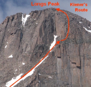
A preview of our plan to summit Longs Peak via the Kiener's Route

A preview of our plan to summit Longs Peak via the Kiener's Route

(1) Chasm Lake

As we approached the lake’s dam, we were hoping the lake would still be frozen over so we could hike over instead of around it. Going around is a significant bother as there is no “shore”; it requires a scramble over talus. And worse, the southern shore (the direct line to Lamb’s Slide) is blocked by cliffs, so we’d have to take a big detour to our right, around the northern side of the lake. But no; the ice was melted through in the center. We had to go around.

As I moved across the talus, I lost sight of Brian. I assumed he found a path lower down the talus, closer to the lake. Once I was about ½ way around the lake, I was surprised for a moment to see Brian walking on the ice about 20-30 feet from shore. But my surprise didn’t last as Brian frequently likes to push it when it comes to walking on lake ice.

Then I noticed he was shiny. He looked wet!

(2) Brian’s Self Rescue

Brian noticed me looking at him, and he motioned for me to approach. I moved down to the lake to join him, and found that the ice did not reach back to shore. Brian asked me to extend a hiking pole to pull him as he jumped the gap from the ice to the shore. He made it without adding significantly to his moisture level, so I asked how he came to be dripping wet. He explained that he had fallen through the ice, but had managed to escape a watery grave by crawling back onto it. I guess the ice was thin enough that when he went through, it broke up all around him into small floes: small enough to not trap him; big enough for him to get on.

He hadn’t yelled for help or even let me know he was on the ice. I would never have found him. He was lucky to be able to save himself.

(3) Complete the trek to Lamb’s Slide

After a short break to let Brian pour water out of his boots and wring out his socks, we continued around the lake and then up to the foot of Lamb’s Slide.

(4) Climb Lamb’s Slide

We reached the bottom of Lamb Slide and stopped to put on crampons and get out the ice axes. Then, we turned left to head up towards the Loft and Mt Meeker. We climbed about 800′ of elevation and exited at the first place it looked possible onto snowy ledges. We would traverse these ledges to the right until we reached the Broadway ledge proper. Along this thin ledge, we knew we would encounter snow & ice and at least one exposed technical section.

And, Brian needed to drain his boots again so we took another short break.

(5) Traverse Broadway Ledges to Horsby Direct Dihedral

The first corner we reached was covered in snow; I think it was the dihedral used by the Hornsby Direct finish to Stettner’s Ledges route. Brian headed across to check the conditions, to see if we needed a belay. He was planting his axe and kicking steps until about half-way across, he hit rocks just under the snow. Unable to gain secure footing on the main path, and with a large bulge of rock above him partially blocking his way, he moved lower to find solid footing on some exposed rocks below

I yelled out that the rocks looked unstable, and that we should setup a belay. Brian said he thought it would be okay. Just as he stepped down and put his full weight on a large boulder, it rolled over and fell out from under him.  It careened down onto Lamb’s Slide, hundreds of feet below. In that instant, I knew he was a goner. I stared blankly and screamed “rock” as a warning to anyone below.

By pure chance, Brian dropped straight down and landed squarely on another boulder only a foot or so lower that stopped his rapid descent into the afterlife. Brian looked back at me and offered up a profound, “whoa.” He then took the last step to reach the far ledge. We paused for a moment to listen for voices, but heard nothing but our own hearts pounding in our ears.

No one had been hurt, and we wanted to keep it that way.  Brian set up a belay anchor, and then I threw his end of the rope to him so I could get a belay past the airy bulge.

(6) Complete Broadway Traverse

We continued the traverse past several loose, snowy slopes to reach the far side of the notch couloir.  The route directions in Rossiter’s “High Peaks” guide book indicated a start within the Notch, but once again (as in 1996 see my Kieners’ …er, Notch Route trip report) I could not spot a likely start.  We decided to stop beneath a broken rock face leading up toward some fins of rocks. This looked to be a way to get into the Kiener’s Route.

We stopped for a snack and to change gear. Brian took his boots off and poured out a combined pint of fluid.  I didn’t think to see if it was just water, or if he’d peed himself a short while earlier.

Sitting squarely in the center of the “East Face” of Longs Peak, I felt that I was in the best spot on the greatest Colorado mountain. The combination of spectacular views, modest danger of dying at the moment, and the thrill of expected excitement to come felt unmatched.

(7) Climb Kiener’s Route to the Summit of Longs Peak

The upper portion of the Kiener's Route

The upper portion of the Kiener's Route

Brian took the first lead up the broken rock and over a chockstone; it was low 5th class climbing. I took the second lead up a narrowing chimney (about 3 feet across) to its end, and then up a waterfall to a big, grassy ledge. This pitch was 4th to low 5th class, and was the end of the technical portion of the route.

To speed things up without completely throwing caution to the wind, we simul-climbed up the broad ledges at the margin of the face (above the Diamond) for about 500′.  Once the terrain became gully-like with good hand and footholds, we unroped.  From this point on, the climbing difficulty was never harder than 3rd class.

At the end of this section, we stood in front of a massive cliff that separated us from the summit. It was very imposing and looked impossible to overcome.  I remember that my heart sank the first time I stood on that spot and looked at the impassable obstacle until I remembered the escape used by my guide to finish a climb on The Diamond.

Brian and I headed up and right, toward the Diamond face, and looked for large blocky rocks on the right. We climbed over the blocks and around the corner on a ledge to mount the north face of Longs.

From here, it was a 10-minute, 2nd class hike to the summit.  We reached the summit at 2pm; naturally the weather was deteriorating.  In addition, the summit was covered by flies and gnats, so we got ready to leave quickly.

(8) Descend the Cables Route

Just as we rose to head toward the Cable Route raps, a cloud rolled in and obscured visibility beyond 50 feet. Fortunately, we were able to feel our way down, having made the descent a couple times before. In a short time, we completed the second rappel and were looking over the impressive “Chasm View” to admire our path.

The hike down from the Boulderfield was a long one, as always. But, in the end, we had suffered and persevered 14.5 hours to ascend approximately 4800 feet and accomplish a classic mountaineering goal. And Brian had a very lucky day.

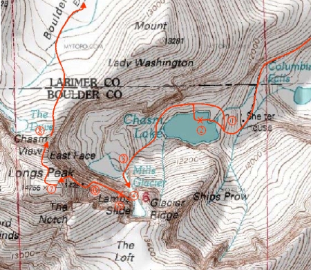
Our "lucky day" route up and down Longs Peak. The "X's" mark the spots of Brian's found luck.

Our "lucky day" route up and down Longs Peak. The "X's" mark the spots of Brian's found luck.

Our route had 8 major sections

  1. Hike to Chasm Lake
  2. Traverse around lake and Brian’s self rescue
  3. Completion of traverse to foot of Lamb’s Slide
  4. Ascent of Lamb’s Slide to Broadway Ledges
  5. Traverse to top of Hornsby Direct dihedral and Brian’s second lucky break
  6. Completion of traverse to start of Kiener’s Route
  7. Ascent of Kiener’s Route to Longs Peak summit
  8. Descent of Cables Route to Chasm View and back to car

See all Trip Reports