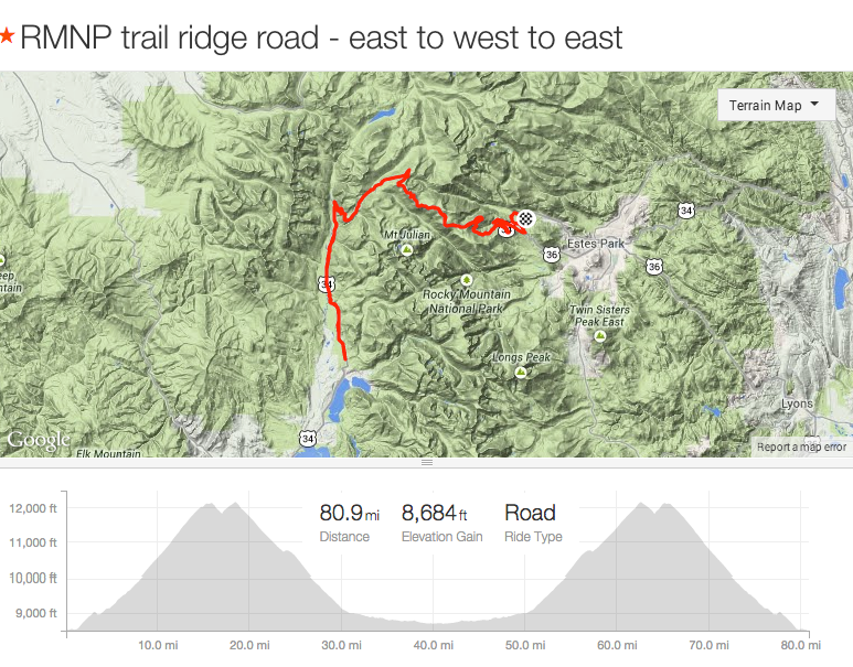
Trail Ridge Road in Rocky Mountain National Park ascends up to 12,183 feet as it passes over the Continental Divide, connecting the cities of Estes Park and Grand Lake in Colorado. It is the highest continuous road for automobiles in the United States.
The weather had started to trend colder and wetter, and I still had my heart set on riding over Trail Ridge Road from Estes Park to Grand Lake (and back) in 2014. I knew it was important to not wait too long since Winter hits the top of Trail Ridge Road early and often (see photo of snow plow).

Trail Ridge Road being plowed in Spring (303 Cycling)
The idea for this ride came from my friend, Phil, with whom I had twice ridden up the eastern side of Trail Ridge Road, to the Alpine Center, and back down (43.8 miles, round trip; ~5037′ elevation gain). Phil couldn’t follow through on what I feared was the last good weekend, but another friend, Chris was game for the extended journey. We booked Sunday, September 14 for the attempt.
Trail Ridge had been used by native Americans to cross the mountains between their home lands in the west and hunting areas on the east side. Arapahoe Indians called the trail located on the ridge as “taienbaa” (“Where the Children Walked”) because it was so steep that children could not be carried, but had to walk.

Trail Ridge Road profile starting from Grand Lake and end at Estes Park (Wikipedia)
Our ride would start just outside Estes Park (and a bit inside the northern entrance to RMNP), and would take us over the Continental Divide, near the Colorado River’s headwaters, and end just outside of the western entrance to RMNP (near the town and body of water called “Grand Lake”). Of course, from there, we would have to turn around and retrace our path to get back home. Our cycling adventure would cover approximately 80 miles and would climb (and descend) about 8,700 feet of elevation, and nearly all of riding would between 9,000′ and 12,000′ of elevation (more mileage above 9000′ than the 120-mile Triple Bypass ride).
The Start – 6:30am
We started up the Trail Ridge Road in the dark at 6:30am, shivering from the freezing temperatures the weatherman predicted we’d find. We started at such a terrible, cold hour to reduce the traffic we’d dodge (tourists sleep in) and to minimize our exposure to the possible afternoon thunderstorms (moderate likelihood; devastating consequences).

Photo of Many Parks Curve in 2013, taken at dawn. The shadow of photographer (me) can be seen on right half of photo.
Riding hard to warm up, we quickly passed West Horseshoe Park, where the road signs warned of frequent encounters with bighorn sheep, deer and elk (but, I guess they slept in as well), and then we went by the Horseshoe Park Overlook before we finally had warmed up enough to shed some clothes. We stopped at the intersection merging US-34 with US-36 to remove a few clothing layers and eat a bite of food, and then we turned right to follow Trail Ridge Road past Hidden Valley. From Hidden Valley (9,239′), we knew we had 10.5 miles of 5% grade road that climbed 2,898′ to reach the Rock Cut (approximately the start of the up and down traverse to the Alpine Center, 4 miles away). That was our first objective.

A photo I took of Brian at Rainbow Curve in 2012, with Ypsilon and Fairchild mountains in the background.
We continued upward, passing Many Parks Curve and later a sign announcing we were 2 miles above sea level (5280′ x 2 +10,560′). Higher still, the trees we passed became increasingly beaten down by the brutal weather they endure for much of the year. After we passed the Rainbow Curve, a tourist favorite for the amazing views of the northern end of RMNP, we passed through the treeline. The next 11 miles would stay above the treeline, which meant no protection for cyclists from the freezing wind we were sure to meet.
Treeline is the edge of the habitat at which trees are capable of growing. Beyond the tree line, trees cannot tolerate the environmental conditions (usually cold temperatures or lack of moisture). The tree line should not be confused with a lower timberline or forest line, which is often defined as the line where trees form a forest with a closed canopy.
~ Wikipedia
Amazingly, we didn’t have the wind I’d always before had to endure. Feeling lucky and fast, we hurried through the Rock Cuts (12,137′), and started the 4.5 miles of riding which would remain at an altitude of around 12,000 feet. We started down the first long descent of the day, and enjoyed the rest as well as the awesome feeling of speed. But all too quickly it was over, and then we had to climb back up every one of those ~400 feet of altitude and then some to reach 12,183′ (the highest point on Trail Ridge Road). One last fast descent led us past the Gore Range Overlook and then to the Alpine Center, which we reached at 9am.
As I feared, it was closed until 10:30am, which meant no source of water to replenish our dwindling drinking supplies.
Alpine Center (11,717′) – 9:00am
After putting on my rain jacket to cut the wind (and windchill), and with dehydration looming, we set off down toward Grand Lake. I had never traveled Trail Ridge Road between the Alpine Center and Grand Lake; I was excited to be exploring a new part of RMNP.
From the Alpine Center, the road immediately hits the hairpin Medicine Bow Curve, which displays a sign indicating the State of Wyoming can be seen in the distance. And, as the road steepened, so did our speed. I quickly lost my body heat and started shivering.
Continuing the decent, the road reentered alpine forest and then reopened as we approached Poudre Lake (the official “source” of the Colorado River). The sunshine felt so good. Once past the lake, we went over the Continental Divide, the virtual line marking where all water east of the line flows towards the Atlantic and all water to the west flows to the Pacific.

Trail Ridge Road map (by Darekk2)
Trail Ridge Road route Sept. 14, 2014
Once the road reentered the forest (and we lost the sun), I had to stop to put on my fleece jacket under my rain jacket. I just couldn’t stand the shivering it any longer.
Chris went by me while I changed, and then I happily spent the next 30 minutes chasing him down, warmly.
Two miles after the last of several hairpin curve, we went past a sign for the Colorado River Trailhead, which facilitates a modest walk to the Colorado River where is it only a small stream. This also coincided with the end of the steep descending.
Continuing toward Grand Lake, I was still hurrying to catch Chris. This distraction was welcome given how dull (flattish, straight, not much to see) it was to ride this 10 miles of road simply to get water at the Kawuneeche Center.
Dehydration on a long bike ride leads to phone calls to annoyed wives who have to drive a long way to bring stupid husbands home.
I caught Chris after a few miles of this flattish section, and then we continued down the road that was getting warmer and warmer, especially to those wearing fleece sweaters beneath rain jackets.
We reached the Western RMNP entrance around 11:30, and after stopping to make certain we could get back into the park, we continued another mile down to the Kawuneeche Center.
Kawuneeche Center – 11:30am
Ah, the half-way point. All we had to do was turn around and go home. Unfortunately, it had taken us 4 hours to do the first half, so we were going to have a long day. But first, lunch!
After a 30 minute lunch break, and topping off our water bottles, we started for home.
The reclimb of the flattish 10-11 miles of road was a misery, but then we got to enjoy (translation: suffer on purpose) the 2,604′ of climbing from the Colorado River Trailhead to the Alpine Center (about 10 miles of 5% grade road). And, going slower allowed us to enjoy the scenery whenever we managed to get ahead on our breathing and didn’t have to stay on the edge of the road to let the cars go past.
Once we passed Medicine Bow curve and turned to head toward the Alpine Center, the brutal mountain winds found us. It was unreal; only the 40 mph, freezing winds on Pikes Peak were worse. Fortunately, we only had to ride 1/4 mile before turning off to get more water/food at the Alpine Center. We arrived at 1pm, and we found that the tourists had decided to come to the Alpine Center. Not one parking spot was available, and cars were crawling through the lot hoping to catch someone leaving. It reminded me of shopping on the day before Christmas.
Average daily summer wind speeds at the Alpine Center are about 48 mph with gusts up to 79 mph. During summer, winds are generally most turbulent at midday and least turbulent at sunrise. Alpine visitors have a unique opportunity to be standing in a breeze one moment and a hurricane-force wind the next.
~ National Park Service
Alpine Center – 1pm
We decided to stop for a lengthy rest inside the gift shop to get our bodies ready for the long push exposed to the terrible wind. The tourists were packed into the already overstuffed (with stuff for sale) gift shop / café; I suppose they were hiding from the wind as well. Everyone was startlingly friendly. We were approached a number of times by people who wanted to talk about cycling. It was quite fun until there was a gigantic crashing noise which indicated someone had knocked over one of the large glass structures containing breakable, expensive items for sale.
That was our cue to head home.
We started up the first climb toward the Gore Range Overlook, competing with cars for road space and heading directly into the teeth of the wind. The pace of riding was painfully slow, but at least I had put on all my clothes to avoid hypothermia.
Fortunately, the wind direction remained largely out of the west, so we only had to deal with the headwind during the opening climb. Generally, we had side-winds, which was unsettling but not physically challenging. And on the last climb of the day, we actually had a tailwind pushing us up the mountain. Nice!
Fairly quickly we reached the Rock Cut, which left only the descent, albeit a very long one.
After an hour of careful avoidance of speeding cars and oblivious pedestrians for an hour, we reached my 4Runner at 2:30pm.
Finish – 2:30pm
We had hoped for a 6 hour ride, but took 8 hours including over an hour of stoppage time.
The ride not only took longer than I thought, it felt harder than I expected. After-the-fact, I attribute it to the long exposure to high altitude….or old age.
We had ridden 81 miles and climbed (and descended) 8,700′. A worthy effort for a day in the Rocky Mountains.
Another great ride was in the books.


