July 13, 2013

The Sharkstooth taken on approach in July 1992
I did my first rock climb of 2013 on June 30 and was amazed to discover that this latter-day cyclist missed his rock climbing days. It had been over a year since I had done any climbing on non-snowy or icy rock, and afterward I found myself actually moved to happiness simply by thinking of possible climbs to do this summer. And then, after a wonderful day in Eldorado Canyon State Park July 6th, my mind moved immediately to Rocky Mountain National Park (RMNP). I wanted alpine rock, and what better place to start than Sharkstooth (12,630′), the location of my very first alpine climbing adventure 21 years ago this July 10th.
In truth, I suppose I might have gotten ahead of myself a little bit.
The jump from moderate climbs on Eldo’s Wind Tower to RMNP’s Sharkstooth is a rather dramatic one: a short walk from the car at 5200′ elevation for few 2-3 pitch climbs in the sunshine vs. a 5 mile approach in the pre-dawn dark over rough trail and talus gaining 2700′ to begin a 5-pitch climb that would take 4 hours to ascend another 650′ and 1 hour to descend for a 10-12 hour adventure. But I had done it many times before, and so it did not feel like foolish overconfidence to claim I could do it.
And Brian agreed with only the slightest hesitation.

Sharkstooth seen from Zowie in 2010
With such a plan in hand, due diligence includes checking the weather report to understand whether the climbing window is wide, narrow, or closed for the targeted day. The month of July is the height of the thunderstorm season for Colorado and its high peaks, and depending on our overall speed we would need 6 to 7.5 hours after first light to do it: a 30-60 minute talus hop through The Gash to the base of Sharkstooth plus a 30 minute climbing prep (including breakfast) plus 5-6 hours of climbing/descending to get off the mountain. And this not counting another 45 minutes would get us below tree-line, and out of the danger zone.
The thursday forecast was for ‘showers and storms starting at 9am’, but the friday forecast would rule for a saturday climb. While waiting for friday’s report, below is a ranking of possible weather forecasts, from worst to best that I carried in my mind:
Storms starting:
- at or before 10am, meaning less than 6 hours to finish (nope; reschedule)
- at 11am, meaning about 6 hours to finish (everything goes perfectly plus we hike out in storm; take a chance?)
- at noon, meaning about 7 hours to finish (everything goes perfectly; go for it)
- at 1pm, meaning about 8 hours to finish (probably safe; definitely)
- at 2pm, meaning about 9 hours to finish (very safe; a no brainer)
- at or after 3pm, meaning 10 or more hours to finish (no weather risk at all)
On friday afternoon, the forecast improved to ‘storms starting mostly after noon’. We decided to proceed and make every effort to start fast, maintain speed and finish safely.
This ‘go fast’ strategy required three tactics:
- get up very early to start hiking very early
- hike as fast as possible (i.e., hiking fast as possible in the dark)
- reach the trail-less talus right at first light (daylight needed for navigation) to avoid lost daylight
- be first on the rock to avoid having to wait for other climbing parties
Just to be safe, we decided on an extra early start to give ourselves some extra margin for age-related slowness now that we are both over 50. We decided to meet in Boulder at 2:15am and drive together to the Glacier Gorge trailhead in RMNP for a 4am targeted hiking start. The only obstacle to starting even earlier was the need to have some daylight to navigate the giant talus field in The Gash below Sharkstooth; if we got there too early we would have to wait for the sun to catch up.
The Day
I got up at 1am and met Brian at 2:15am. After throwing my gear into his truck, we started from Boulder right on schedule and arrived at the trailhead (9,240′) a bit after 3:30am to find only 1 or 2 cars. We assumed they were left the day before by bivying parties since no one could be crazy or worried enough to arrive even earlier than us. After an bit of last minute dumping of extra gear and water to save weight (and needless suffering), we started up the star and moonless trail at 4am.
We made great time in part by not stopping to rest. It was about 5:15am as we approached Andrews glacier in the dark. Brian said, “headlights,” and my heart fell. Damn. As I looked to where he pointed, Brian said, “I wonder what they are doing up there?” They were way off the hiking route to Sharkstooth and seemingly headed toward nothing that we knew. “Perhaps they are planning a climb up that way,” Brian said hopefully, but without conviction.
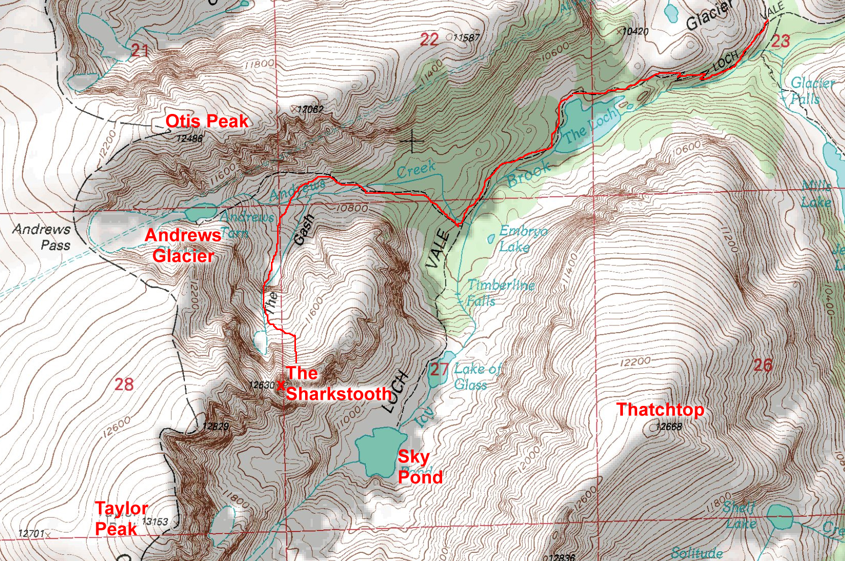
Approach to the Sharkstooth via the Loch Vale trail and junction to Andrews Glacier & Pass
The sky was lightening quickly and was sufficient to start across the talus when we arrived at 5:30am. The lightening sky also revealed a cloud filled sky.
It wasn’t long until we could see that they were headed toward Sharkstooth. I said, “Let’s go faster.” And we did.
We used a patch of snow to gain a chunk of ground on the other party, and a short distance later, we passed them. They didn’t know the area, but they were not slow. And now that we were showing them the way, we had to keep up the brutal pace. We did it. We arrived at 6am, about 15 minutes before they did, ensuring a clear path to the top. When they arrived, we discovered they had started hiking at 2am and simply got lost in the dark. One of the cars at the trailhead was theirs!
It is worth noting here that we only took 2 hours to hike 5 miles and ascend 2,700′ to reach the base of Sharkstooth. That is 2.5 mph and 1,350 feet per hour, with 20 lbs of iron in the pack. That pace is off my personal speed chart and a full 50% faster than we managed almost 17 years ago as 34 year old men. With such evidence in hand, I am pleased to report that Brian has regained nearly all of his pre-illness strength, and that my increased cardio fitness (and lower weight) has held off the ravages of age for a bit longer than expected.
Pitch 1:
After changing into dry, warm clothes and consuming a bit of breakfast and 1 of 2 liters of water I brought for the day, I started up the rock at 6:30am, taking the most obvious dihedral. My fingers quickly froze as I slowly worked past the wet vegetation, straight up to a large ledge directly below the slot marking the start of the 2nd pitch. They key for us was to stick to the route we knew to minimize any lost time. The sky was not yet threatening, but did look like it could rain in the next few hours.
Pitch 2:
Brian continued straight up until reaching a ledge at the top of the prominent left facing flake. I followed the rope without much thought for route finding until I reached the flake. I paused to decide whether to face climb the rock to the left (as I had done before) or simply layback up the flake. I decided to do the classic layback to reach the belay in style.
Pitch 3:
View of Estes Park from top of 3rd pitch
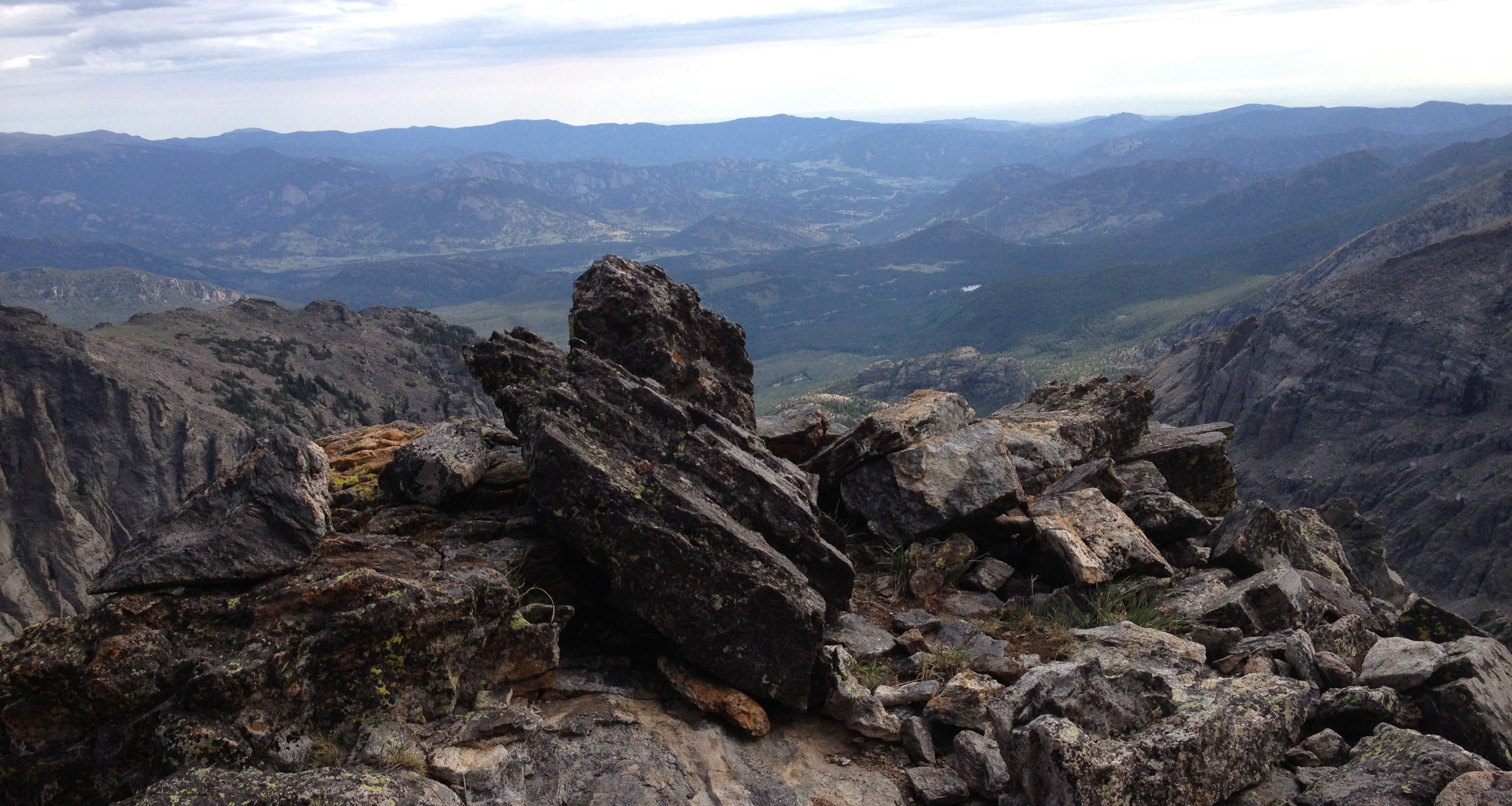
I continued straight up the steep but bucket-filled terrain to reach a big flat ledge that marked the start of a recognizable arete. Every variation of the NW Ridge route must hit this ledge, as it is the first part of peak that actually forms a ridge. The views are spectacular off both sides. This was the longest pitch of the day, taking nearly the entire 200′ rope.
At this point, the clouds seemed to be thinning. It seemed that we would get lucky with the weather, as we have so many times when we show proper respect. Still, it looked to be raining in parts of RMNP, so we stayed alert.
Pitch 4:
Brian climbed up the off-width crack and belayed at the next large ledge below the white face. I followed after taking many photos in a foolish attempt to capture the majesty of the views from that spot.
Pitch 5:
I took the last pitch, starting by moving left of the white face and climbing the rough rock toward the summit. I stayed left to avoid rope drag, continuing past the next big ledge to belay a few feet below the summit level.
We untied and scrambled to reach the summit at 10:30am. We enjoyed the views for a moment before heading down to get some water; it had been 4 hours since our last drop of water. And, while the weather had held, we were still at least 1.25 hours from treeline.

Panorama from Sharkstooth summit July 2013
The Sharkstooth rappels are always interesting for the questionable anchors; we sacrificed a sling on on the middle anchor where the slings looked particularly aged. After downclimbing the final 70 feet, we scrambled down few hundred feet over blocky talus to reach our packs. I found that the marmots had knocked my pack down from a ledge in a vain attempt to get my food (I had carried it with me).

View of Petit Grepon and Sky Pond from Sharkstooth rappels
We got back to the packs right at 11:30am. With the improvement in the weather, we stopped to rehydrate and eat lunch before starting the long walk to the trailhead. I finished my last liter of water and a couple Larabars.
The steep descent was brutal on my aging knees, but we kept up a good pace to get to treeline before any late arriving weather spoiled the day. We continued back down the way we came up; I was dreaming of ice for my knees.
We arrived at the trailhead at 2pm for a 10 hour truck-to-truck roundtrip.
Not bad for two 51 year olds.
Timeline:
- 1:00am – I wake up before alarm goes off after 3.5 hours sleep
- 2:00am – leave the house for Boulder
- 2:15am – meet Brian at 29th street mall and leave together for RMNP
- 3:30am – arrive at Glacier Gorge Trailhead parking lot
- 4:00am – start hiking toward Sharkstooth
- 5:15am – see headlights ahead of us
- 5:30am – arrive at turnoff for The Gash and The Sharkstooth; first light
- 6:00am – arrive at base of Sharkstooth (15 minutes ahead of other party)
- 6:30am – start climbing
- 7:15am – finish 1st pitch
- 8:00am – finish 2nd pitch
- 9:15am – finish 3rd pitch
- 9:45am – finish 4th pitch
- 10:30am – finish 5th pitch; arrive at summit
- 11:30am – descend to base; eat lunch
- noon – packup and leave for trailhead
- 1:00pm – arrive at Loch Vale
- 2:00pm – arrive at trailhead and leave for home
- 2:30pm – stop in Estes for ice
- 3:30pm – arrive in boulder
- 4:00pm – arrive home 14 hours after departure to hike 10 miles, ascend (and desend) 4000′ of elevation, burn 4000 kcal
- 4:05pm – soak in hot bath until cooked and pruned


