Posts Tagged ‘14ers’

Poor Teamwork on Mt Columbia

September 23, 2010

“The only way to have a friend is to be one.”

~~Ralph Waldo Emerson

When we play atop the high peak alone, we have only our own interests to consider.  It is a simple matter to set a goal and build a plan to accommodate our interests, skills, fitness and tolerance for risk.  When we are alone, we can enjoy the high peaks the way we want without any compromise.  But it is simply more fun to adventure with people we like and trust.  And as an added bonus for team-based adventuring, a collective effort can minimize the risks inherent to playing in a dangerous environment.

But a team is not a group of individuals acting in their own best interest.  Members of a “team” demonstrate cooperative and supportive behavior in a common effort to accomplish hard goals.  Good team members value a relationship built over time and expressed in mutual understanding, honesty, sympathy, empathy, and loyalty.  And, the knowledge of one-another within a team allows complementary abilities and coordinated efforts to generate synergy, which enables a “team” to be greater than the sum of the individuals.

A good team offers safety by being supportive and trustworthy.  A bad team doesn’t.

This trip report is about a bad team, of which some of the members successfully summited on Mt. Columbia on May 5, 2000.

Trip Report

On Saturday, May 5th, Brian, Susan (my girlfriend of 4 months and future wife), and I set off from the N. Cottonwood Creek trailhead to climb Mt. Columbia.

Brian (Climbing Partner) and Susan (girlfriend of 4 months) preparing for early start on Mt. Columbia (Colorado)

Brian and I had hiked past the full length of Columbia two years prior when we climbed Mt. Harvard via its South Ridge starting from the N. Cottonwood Creek trailhead; we felt we knew the area well enough to skip a full-on planning effort to climb Columbia’s West Flank and South Ridge. We were right to be confident that the two of us could figure out a way.

But we were wrong to remain confident once we added an inexperienced member to the group.

In the week before the attempt, Susan expressed an interest in joining me on one of my trips. Without thinking, I invited her to join us on the upcoming Mt. Columbia’s climb, and she accepted. If I thought anything, I suppose is was that any difficulties that surpassed her skill set would be at the end of the hike, and so would allow her to simply wait below for a short time if we could not protect her. When I told Brian of the addition to the team, he agreed it would be okay.

We were both wrong in assuming that adding Susan, an inexperienced 14er hiker, to the group would pose no significant problems.  But, I would stand alone in blame for the biggest leadership mistake of all.

We drove up Saturday night for a pre-climb car-camp. It would be a long day (Dawson estimate was 11 hours) so we needed a very early start from a trailhead a long way from home.  It was a beautiful night for sleeping under the stars, with clear skies and moderate temperatures. We enjoyed a couple hours of camaraderie before turning in for a short night’s sleep.

The next morning we hiked in the pitch dark and soft snow.  I had brought snowshoes for Susan, so she was fine; but I had skis, which I put on and took off multiple times as soft snow and exposed rocks competed for my attention. As the trail approached Columbia, snow started to fall and the wind picked up.  It was getting cold.  But going uphill kept the furnace burning hot, and we continued along following Brian who I assumed knew the way to go.

It was hard to see our destination through the trees, but eventually Brian said we should leave the trail. We turned toward Columbia and made our way closer to the West Flank that looked steeper that I expected. He stopped hiking on a pile of talus under a steep, icy gully and took off his pack. I asked if we were taking a break; Brian said this was it.

I couldn’t believe it! I stared at Brian in disbelieve that he would think this route would work for Susan, and then I looked at Susan.  She had a pleasant smile, and was expecting the best of a great day.  Oh shit!

I didn’t bring crampons for either of us, and I didn’t bring an ice axe for Susan; and she didn’t know how to use such equipment, anyway.

“What the heck, Brian? Isn’t there an easier way up?  Susan can’t climb that!” I communicated to Brian in another glance.

“I think this is it,” was all he said.

We stood there, freezing in the wind, for another moment.  Then I told Susan the bad news.  She couldn’t continue and it wouldn’t be smart to wait in a cold wind for 5 hours.  I told her that it would be best if she went back to the trailhead, where she could get protection from the wind (in my 4Runner), and even catchup on a little sleep.

Columbia from Yale: our route vs. standard

Susan was agreeable, as always, but she didn’t know the way back. I assured her that it would be easy to simply follow our tracks in the snow, and if she did get lost she could simply listen to find the river, and then she would keep it on her right and follow it back to the bridge crossing to find the trail. I pointed her in the right direction and she left.

Susan adds…

Joe was always going on some adventure or another on the weekends.  I thought I’d like to go along, and he said yes.  We started hiking so early it was dark, but I just followed behind.  We stopped hiking below a very steep snowfield, and Joe said he hadn’t known it was so steep.  I was a little upset that I couldn’t finish, but more so that I would have to hike back alone.  I was worried about getting lost because I hadn’t paid attention to the trail during the hike in.

Brian put on his crampons and disappeared up the steep, icy gully.  I followed by kicking creases in the ice & frozen snow where Brian had weakened it with his steps, and I hauled on trees wherever possible.

Progress up the slope was slow, for obvious reasons.

Once we reached the South Ridge, I hoped we were close so we’d be able to head back soon.  But no.  We still had a lengthy ridge traverse to reach the summit. And the wind became brutal.  With the skis acting as sails, we were tossed around like toys.  Brian even took a spill into some rocks after a big gust. But we made it.  And, although it was a bit late for snow safety, the cold wind gave us confidence.  We hurried back down the South Ridge past our ascent path to reach the a major gully, which probably would have been a better ascent path. (note: the standard ascent path would have been even better; see route photo.)

The ski descent was excellent. The snow was mostly in good shape, except for an unseen slushy spot that initiated a spectacular tumble by me.  And rocks were falling from above. But it was a wonderful period of joy that allowed no thoughts of what might have gone wrong for Susan on her retreat.

As we started back, I was surprised at the extent the trail had melted out.  It meant we could not ski out very well, and it meant the trail might have been hard to follow. I started wondering about Susan’s fate.

Columbia route map

We trudged on and steadily ate up the trail. Shortly after we crossed the creek, we saw Susan hiking toward us. She was delighted to see us as I was delighted to see that she had made it back.  I figured she had gotten bored and was coming to meet us.

But I was wrong.

Susan explained that she had not yet made it back to the trailhead.  She had been continuously hiking up and down the trails, looking for something that looked familiar. She was actually delighted to see us because finding us meant that she wouldn’t die that day.

Susan adds….

I tried following the tracks, and I nearly made it to the trailhead before getting confused and turning around.  I hiked back and forth on the trail for many hours until I found the Joe and Brian heading back.  I was so relieved that I wasn’t going to die that I wasn’t even too mad.  I had a long day of quality time with myself.

I was amazed that the situation had spun so far out of control.  And I was embarrassed. It was entirely my fault, and it forced me to think hard about the proper behaviors for teams with unequally experienced members.  Very clearly, I had made two serious errors

  1. I failed to understand and/or assume responsibility for Susan, who completely trusted me to keep her safe because she could not fully manage her own safety in that situation
  2. I failed to abandon my personal goal (bag summit of Columbia) when it became incompatible with my responsibility for Susan’s safety

It became clear to me that, for a good team, we need people we know, people we trust not to selfishly, foolishly or ignorantly put us in danger or fail to respond properly to an emergency.  And, finding a group of people is just the first step.  We then need to turn our “group” into a “team” by continually strengthening relationships and learning about each other in the context of shared adventures that we choose for suitability to the current level of trust and experience among the members.  And, most importantly, the experienced members of a team must assume responsibility for the inexperienced members whenever they adventure together, even when it means to give up on the summit to keep a team-member safe.

This must be the first rule of teamwork.

See essays:

And all credit to Susan for finding a happy ending to the story. She stuck with me, after all; our 10-year marriage anniversary is coming up in 2011.

See all 14er trip reports

See all trip reports

Unnamed (and Mt Antero)

June 10, 2010

May 27, 2000

With Memorial holiday giving us an extra day I was hoping for a bigger than normal adventure…but Brian couldn’t pull off two nights out. We had to make do with a single day with an early start.

Brian suggested Antero, with the idea that we could get a good ski descent. Since Antero was one of the few unclimbed Northern Colorado 14ers on my list, I loved the idea.

The drive up, which started late due to my tardy arrival, was interrupted by a missed highway turnoff and an accident that closed the highway for an hour. To make use of the time and avoid eating dinner after midnight, we got out the stove and made dinner on the side of the road. And, it still might have turned out okay, except the approach road was very long and slow going. We made it to 11,300′ before stopping to setup camp; we settled in for sleep at 1am. With a 5am wakeup call forthcoming, it would be a short night.

Brian on final approach to Mt Antero summit

We started moving at 5:30am and took 3 hours to ascend from camp at 11,300′ to the Mt Antero summit at 14,269′. We followed the winding road up, but didn’t trust where it led after passing the summit ridge; we followed the ridge to the summit. Unfortunately, we also discovered that there wasn’t any snow left on Antero except for a thin strip about 50 feet wide and 500 feet tall on the southern ridge leading to the summit.

We enjoyed the summit for a short time and discussed our options for the day.

My rapture on the summit of Mt Antero

Since we couldn’t get our ski descent, we decided we’d head over to a tall peak across Baldwin Gulch that had a very nice snow covered eastern slope. But we had to hurry since the snow had been in the sun since dawn.

We descended Antero following the old mining road which turned out to lead to the final stretch of the summit ridge.  Once at the start of the switchbacks, we left the mining road and headed around the cirque toward the unnamed peak.

Where's the snow? On the way to some snow on 'Ol Unnamed (North Carbonate?) from Mt Antero (in background).

The progress was good until we got to the exposed scree & talus on the SE ridge of the unnamed peak.  It was murder for tired legs.

We found the summit to be protected by a weird cornice that required crawling over to get to the top of the peak. I needed a rest, but with the sun burning on the snow, we stopped only momentarily before setting off for the steep descent slope.

As we feared, the snow was soft, and possibly dangerous. After a short pow-wow, we decided we’d proceed…with the extra precaution of staying on opposite sides of the face and only skiing one at a time. The snow turned out to be great, and we had a great time descending 1800′ in only a few minutes.

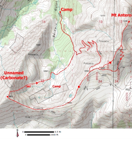
Our route from Baldwin Gulch to Mt Antero and North Carbonate(?)

The hike out was mercifully short; we made it back to camp at 1:30pm for an 8 hour, 8 mile, and 4000′  day.

And sometimes, one day is enough.

In the years afterward, I came to believe that the peak had an unofficial name, “North Carbonate”.  And, just recently, I discovered that the officially unnamed peak got an official name in 2005…it is now called Cronin Peak.

Formerly known as “North Carbonate”, this mountain now has an official name, approved by the Department of Interior in May 2005. Cronin Peak is named in honor of Mary Cronin (1893-1982) who in 1921 became the first woman to climb all the fourteen-thousand foot peaks in Colorado.  ~summitpost

See all trip report

See all 14er trip reports

Mt Evans Extreme

June 2, 2010

It was the end of May, 1999, and I had just returned from my Great Bolivian Adventure. I didn’t have time for a full day of mountain fun, and, naturally, Brian wanted to ski; we picked Mt Evans as a good, close-by solution, with the thought of seeking the route less travelled to spice things up. And, I was anxious to see how much better my performance would be with my Bolivian, high-altitude acclimatization.

A view of Mt Evans and the rocky ridge separating Mt Evans from Mt Spalding

We drove up early to get good snow conditions and parked in the parking lot beside Summit Lake. We started working our way forward, postholing our way to the top of the bowl rim so we could get a good view of the options. We decided to angle right toward the rocky face dividing Mt Evans from Mt Spalding, aiming for the snow slope that reached nearly to the top of the ridge.

Brian nearing the exposed rock portion of the climb. The hard snow climbing occurred just before this spot.

Brian picked it, and I went along; I thought it looked interesting and possibly climbable. I forgot that we didn’t bring a rope; read: no belay.

The climb started like any other moderate snow climb, but about 2/3rds of the way up it got hard; the route became steep over mixed terrain.  And I was huffing and puffing with poorly functioning lungs. I whined to Brian that my allergies were acting up and trying to suffocate me.

The last 50 feet was thinly covered rocks; very little for the crampons and nothing for the axe to grab onto. On two separate occasions I had to commit to moves that I expected to fail, when failure meant some very bad outcomes. My alternative was to stay there for the rest of my life. The worst was at the very top, which turned into a moderate rock climb with crampons and ice axe making every effort to kill me.

I didn’t get a belay, but I recall Brian was generous with his words of encouragement.

But we made it to the top of the rim.  Thanks, Pal!

Then we hiked to the summit and enjoyed the well earned views. My breathing was so labored that I swore to Brian that if Colorado made my allergies this bad again, I was moving!  The skies had quickly changed from beautiful blue to looking like rain or snow soon, but we didn’t start down for the North Face until the axes started singing their dreaded electrical song.

We got down well enough. My glissade wasn’t very good due to operator error; I guess I just forget how to do it, having been skiing instead for the last year. Some additional huffing and puffing while postholing had me really annoyed with my physical performance. I had looked forward to kicking Brian’s butt for a change, but my 20,000′ plus acclimatization just didn’t pay off the way I expected.

Brian about to descend the North Face to escape the electrical field around us.

Twenty-four hours later, I knew why:  I had the flu. Isn’t air travel just lovely? At least I could continue living in Colorado with a clean health conscience.

It was my 3rd summit of Mt Evans, and the most interesting so far.

See all trip reports

See all 14er trip reports

Huron, Bloody Huron

May 28, 2010

Our drive, hike & climb to Huron Peak summit

One more time. Brian and I thought we’d back to the Clear Creek Reservoir Road, this time to collect Mt Huron. We knew going in that it would be a 10+ mile hike in the snow with a 4000′ elevation gain due to the winter road closure, but we were on a roll and Huron was next on the list. The only problem would be the inevitable snow storm; the previous week it snowed all the night before. And, it did so again.

It was Brian’s turn to drive; we left his place in Golden @ 7:45pm on Friday (April, 23, 1999) heading toward Leadville.  The Bronco is a slow beast, but it works wonders on poor backcountry roads. Along the way, we were pleasantly surprised to find the roads in better shape than the previous week (when we did Missouri Mountain) despite the heavy new snow in the front range. We figured we’d gotten lucky on the snow distribution.

Brian picked the East Slopes route. At the time I figured it was the worst thing he could find, but in hindsight I suppose it might have been because Dawson wrote that the East Slopes generally have more snow. Well, we did have plenty of snow.

Aiming for the Clohesy Lake trailhead, we pulled off US Highway 24 onto Clear Creek Reservoir (dirt) Road. We immediately knew we had been mistaken about getting lucky with the snow; the accumulation was much worse than the previous week.  We drove past our previous camp at Vicksburg and to the Rockdale townsite where we turned onto the 4×4 road heading toward Clohesy Lake trailhead, but only managed to get 1/3 mile up the 3-mile road before the snow was too deep to drive even for the Bronco.  And, believe me, that means something. A determined Brian forced his way cross Clear Creek before giving up on the drive; that crossing was much more interesting than I like at 11:30pm.

We setup camp as quickly as frozen fingers allowed. And then sleep came quickly, and so did 5am.

The first thing we noticed was the temperature.  It was way too warm.  Crap, it was going to be a hellish, soft snow day.

The initial hiking over the 2.7 miles remaining of the 4×4 road was rather flat; we started at 10,000′ and took 1.5 hours to gain 800′ of elevation. I hoped in vain that it would be a nice downhill glide 10 hours hence. Still, it was an easy start, for me anyway. Brian broke trail; and for a change, he actually made a trail I could use instead of gliding across the surface like a modern day Legolas. It was odd to hear him grumble.

Once we cleared the treeline, we could see heavy snow covering the ridges descending from Huron.  It was still early and already a slide had occurred, nearly reaching our ascent path.  We kept our distance from the snowy slopes as best we could, and we tried to hurry to minimize our exposure.  But it was a long curving path to reach the couloir ascent to the summit ridge.

Detail on the final stretch to the summit

The final couloir was very steep and icy. So, we didn’t have to fear an avalanche, but the skins were only marginally up to the task of ascending such a steep, slick surface. We slowly worked our way up until about 3/4ths of the way up we had to exit into the rocks on the right to make the saddle.  The climb certainly would have been better with crampons and an axe.

The weather had looked bad all day and continued to do so.  We tried to hurry to the summit, but the snow on the ridge was too soft. I literally had to swim across the sections without rocks to step on. This misery was compounded by my agreeing to bring the skis to the summit, where we sat for only as long as it took to eat a quick snack.

I carried the skis up to the summit and then carried them back down to just above the saddle.  When I dared put them back on, the snow stuck to the base like tar.

Fortunately, by the time we reached the top of the couloir, the skiing returned to a normal state for the day…merely terrible. A few turns into the descent, I hit a rough, icy section and lost it. I hit face first and cartwheeled down the slope, bashing my brains in on every flip. My self-arrest ski poles allowed me to stop after a few flips, but not before mutilating my nose. And this only 2 weeks since making a pact with God to take better care of my nose after allowing me to keep most of it after some frostbite on a cold, windy day on Mt Silverheels.

I bled continually and fell frequently as I attempted to escape Huron with my life and the remainder of my health (and nose).

Once we made it past the lake and reached the 4×4 parking area, the snow had softened enough to become impossible. In the last 3 miles, I fell through the snow 6 times. One time I could not get back up; it was a sort of quicksnow. I finally had to resort to rolling to escape the pit I dug for myself.

We made it back to camp at 6pm for an 11.5 hour day covering 4000′ of elevation gain and 10+ miles of soft snow slogging.  And, I was a bloody mess.

Some trips it is hard to remember that I do this because I love it; but it is important that I remember it.

See all trip reports

See all 14er trip reports

Tying Up Loose Ends

April 23, 2010

It was time.  Finally, it was time that I finished up the list of Colorado 14ers.  I had done all but a few as of three years ago. I didn’t do the last ones in part because they are on the far corner of the state. But the larger part of it was my dying enthusiasm for the list.

My most recent big push was in July/August of 2003; that year I did 14 Fourteeners in July and August. After doing the four in the Sange de Cristo range, I had invited Brian to participate as desired in my plan to finish the 14er list that year:

Brian:

I am looking to finish the 14ers this summer.  My approx. plan for 14ers is follows:

  • Capitol (7/26)
  • Sneffels/San Lois (approx. 7/30-31)
  • Chicago Basin Peaks (during vaca?)
  • Telluride Area Peaks (during vaca?)
  • Pyramid/N.Maroon (?)
Interested in any?
Joe

Brian could only join me on N. Maroon during a N-S-N traverse of the Bells. But, by the end of that August, Brian asked about my 14er “mania” when I indicated I was interested in a non-14er  adventure.  I responded via email with a telling lack of enthusiasm:

Brian:

The mania has dimmed a little:  only 1 trip left and I cannot finish without Culebra (next year at earliest).  I’ll get in the last trip in the next few weeks.

What do you want to do this weekend?

Joe

It didn’t happen.

Three years later, I had worked up another head of steam and was ready to bag Mt Sneffels & San Luis Peak.  The two represented an odd combination of peaks:  one very well regarded among climbers and the other not so much; on average, I hoped it would be a good trip.

I picked August 9-11, 2006 to do it.

My driving route to collect Sneffels and San Luis covering 770 miles and taking 16.5 hours.

It would be a solo adventure, once again.  It turns out nobody wants to spend 16.5 hours driving 770 miles to climb 2 14ers on the far side of the state, and almost no one will do it.

But that’s okay. While I prefer to climb with friends, I also enjoy the added stress and thrill of climbing alone. I also sleep better.

Day 1 – August 9

As I packed for my trip I realized I couldn’t stand to listen to Paul Simon’s Greatest Hits CD another time.  I decided it was time to pickup a Beatles Greatest Hits, like I had when I was a kid.  I love the Beatles. Heck, I was even looking forward to some free hours to just listen to my old music favorites.

I also threw in a couple of gallons of water, a box of food bars, and a book about Abraham Lincoln. And then I was off.

First on the list was Sneffels. It was the good one, plus I wanted to return home from San Luis via 160 & 285 (a very fast trip home I discovered during a return from Durango).

I left Boulder at midday for South Denver, and then 285 south to 50 heading west toward Montrose.

Climbing two peaks 100 miles apart presents pleasant logistical challenges.  Being sequential, any failure in timing would likely cause the plan to fail.  I had to include sufficient cushions and avoid as many unknowns as possible in my planning to avoid the disaster of going home without both peaks (horrors).  My plan was to plan on the easiest route and then op for more interesting climbing, if any, if my speed and the weather were good.

The two standard options for climbing Mt. Sneffels start from the Yankee Boy basin just outside of Ouray.  There is a class 2+ Lavendar Col scramble and a Class 3 ridge climb.  I decided to aim for Lavender Col but take the ridge, if possible, in order to bag the Tour de Sneffels.

Six hours later, I hated the Beatles.  I couldn’t listen again for over 24 hours.  But I needed to concentrate on my driving anyway once past Montrose.

An overview of the approach to Yankee Boy Basin and climb of Mt Sneffels

The access to Yankee Boy Basin was surprisingly easy.  And the shelf road along the way is definitely something to see. I drove up the County Road 361 until I reached County Road 26 which I took to around 11,200′ to preserve a solid approach effort. I had to hunt a bit for a good place to park & camp.  I couldn’t find anything solid, so I decided to sleep in the back of the truck.

Per my usual method, I wanted to explore the road a bit to be sure I knew where to go when hiking in the dark, but I ran out of daylight. I’d just have to wing it.

Then I went old school.  I ate my luxurious Burger King meal and turned in about 30 minutes after dark.  I don’t think I’ve fallen asleep that early since kindergarten.  But then I woke up at 1am.  I dug out my Abraham Lincoln book and read until 3am when I fell asleep until the alarm went off at 5am.

Day 2 – August 10

So there I was, hiking up County Road 26 in the pitch dark and the only person alive on the planet as far as I could tell.  It added a special thrill to an exciting, stressful situation. I loved it!  It also made me think hard about staying safe (position #1 on map). No one would be looking for my body for several days.

The road led to a big looping trail that I followed to Wrights Lake at 12,200′ (position #2).  The daylight was creeping in and I could see Sneffels and the Blue Lakes Pass. My prep work had indicated that the SW Ridge route was far more interesting than the standard cattle path, so I followed the trail around the lake and aimed myself for the pass.

As I stood atop the pass (position #3), I looked around and saw that I was still all alone. It was an awesome feeling. I looked to the north at the confusing mass of ridges that made up the SW Ridge and thought to myself, ‘this could take some figuring.’  I was right.

I had a copy of Roach’s photo and description, but it didn’t matter.  Neither the photo or description resembled like the mountain I was looking at once I was nose-to-nose with the peak.

I stayed to the left side to avoid some early pinnacles, per the guidebook, and then didn’t know what to do.  I continued to the left of the main features to see if I could see anything useful.  I couldn’t, so I returned and found cairns marking a gully.  I climbed the gully to its dead-end and paused to look around.  I could see back down to where I had hiked earlier, and I could see that I could ascend to the ridge if I had rock gear and a belay.

I decided I’d have to backtrack to the beginning to try another way and started down.  But after a short distance, I found a weakness in the rock that looked promising so I gambled on it.  It led to a notch in the ridge and another gully heading down the other side of the ridge.  I climbed into the new gully and saw that I could scramble up to reach some steep climbing just to the west of the ridge that might lead to the top of the ridge.  I was tempted but was afraid I couldn’t reverse those moves if the path dead ended.  So, instead, I descended the gully to the east to see if I might strike gold.  But no.

Left with only two choices, go all the way back to the bottom or try the hard moves (4th class), I took a chance on the hard moves.  It worked (position #4). The hard climbing lasted only 15 feet and then it was easy scrambling to the top of the ridge.

Once on the ridge, I was able to stay on top the rest of the way to the summit (position #5).  There was some terrific exposure that kept the pressure on even after I was past the route-finding difficulties, but the rock was good enough to be safe.

It was a very good route; one of the best among the 14ers.

The Sneffels summit was a good one.  Clearly it was the tip of a mountain, and the views were awe-inspiring. I sat down for my first break for the day and enjoyed an early lunch and a relaxing few minutes. I figured this was the high point of the trip (literally and figuratively) and should be sure to appreciate it.  I didn’t think San Luis would be so nice.

When I heard voices approaching, I started thinking about my need to get to San Luis before dark. It was time to go.

I scrambled down into the standard route and maneuvered around the snow patches and loose rock to reach the saddle.  I then followed a well beaten cattle trail down under the SW Ridge where I found some Colorado Fourteeners Initiative people working hard on a new trail. I stopped to chat briefly and then continued down to the 4×4 parking lot. I thought I would use the nice lot on any return trips, and then followed the road down to my truck (position #7).

I figured I needed 4 hours to drive back up to Montrose and then over to and down CO-149 to Lake City and then to Creede.  As an alternative, I had a vague notion of the possibility of using back country roads to cut across to Lake City.  I figured it might save several hours; but since I didn’t know the roads and didn’t have any way to figure it out quickly, I decided to simply take the way I knew.  Heck, I was even thinking I might be able to tolerate listening to the Beatles again.

My route up Mt Sneffels

As I drove over to Lake City, I realized that I had not done as much prep work for San Luis since the plan was to do Sneffels first.  The route-finding for the climb was supposed to be easy, but the route-finding on the drive in started to feel confusing as I read and drove.  My drive through Lake City reminded me of an earlier reading-while-driving error (see Flying Blind) and I committed to finding a place in Creede to stop and figure it out.

Yet, I already decided I would use the West Willow Creek trailhead because the drive was shorter and the trailhead was higher and closer to San Luis summit.  Also I decided I would take the longer but more gentle drive offered by Roach.  So I knew to look for 3 dirt roads heading west just south of Creede.  But the directions assumed I was coming from the south (from Creede), while I was coming from the north (from Lake City), so I couldn’t follow the mileage instructions. I hoped it would be obvious.

As I approached Creede, I looked for the three dirt roads on my left.  I could only see 2 dirt roads. Shit.

I continued into town and then back out, staying on CO-149, without learning anything useful.  I turned around and started measuring mileage heading south after crossing the bridge over what I hoped was Willow Creek.  The mileage told me that the turnoff for Bachelor Rd was the right one, assuming that I was measuring from the right bridge.  I thought it was my best bet, so I started up the road to see if the remaining directions would confirm I was on the right road.  The first couple turns did seem to work, even if the road signs were wildly confusing. I continued up the road.

About 1/2 way up the road, I became confident I was in the right place. I eventually found a parking lot near a large mine complex, just like Roach said I would. I parked and started getting ready for the night.

I was worried about how I would hike through the mining area, so I decided to use the 30 minutes before dark to figure it out. I found a passage about the approach that said, “…or continue up a 4×4 road 100 yards before parking lot for 1.6 miles to reach 4×4 parking”.  I looked back down the road I’d driven and saw a dirt road heading up a steep hill.  I thought I should give that a try before dark.

I took off just as another vehicle pulled into the lot.  I made the turn and powered up the steep dirt road.  It was a wandering road through some very isolated terrain and crossing the creek a couple times. I wasn’t certain I was in the right place, so I wanted to hurry to drive the 1.6 miles described by Roach to see it would end in a place that looked promising.

The road abruptly turned up another hill, just as Roach’s book described.  I stopped and walked up the road, and found an old road just as Roach described; I concluded that I had found the 4×4 parking, except that I didn’t see anywhere to park.  I pulled off as well as I could at an old campsite and turned in for the night just as darkness fell upon me.

Below is the sequence I used to find the upper trailhead; numbers noted on map:

  1. Turned west off CO-149 County Rd 505 which becomes Bachelor Rd which becomes County Rd 504
  2. Turned left onto West Willow Creek Road (Google says it is USFS 503) after crossing West Willow Creek and continued end of road (4×2 Parking)
  3. Went 100 yards back up West Willow Creek Road
  4. Turned right (northwest) onto unmarked 4×4 road (Google says it is USFS 503) heading up a steep hill and proceeding north 1.5 miles past Equity Creek Mine and to end of road before it turns uphill again to leave the valley

Day 3 – August 11

I set my alarm for first light.  I needed some daylight to figure out where to go since I wasn’t really sure about where I was.

I started up the old road that led to a ridge and a small bump of a hill.  The road stayed to the right of the hill; once on top I could see a nice trail below me that turned out to be the Colorado Trail. I had found it!

Now it was just a matter of time and weather.

I hurried down to meet the trail and then toward San Luis; I wanted to minimize the chance of getting thwarted by weather after coming so far.  My initial thought was, ‘why is the trail going downhill?’

My campsite was at about 11,500′  Then I hiked to the small bump on the ridge at about 12,500′.  Now I was descending toward the low point in the trail at 11,900′. And that is how the day would go: up and down and up and down, etc. I tried to get my mind right and just hike, but it continued to bother me; somehow knowing that the elevation gain/loss would get me my 3k elevation gain just didn’t help.

The trail also had to contour around two basins to avoid losing even more altitude, so it also gave me a “longer-then-necessary” feeling which added to the boredom. And then the South Ridge route was also boring. I plodded up the ridge to the summit and decided that I would not be back.  San Luis was only worth doing once.

I had thought about bagging Stewart Peak while I was close by, but I did not have the proper attitude.  I knew it meant I would probably not be able to complete the Colorado Highest 100 list, but it just didn’t feel worth it after such a boring day.

I started back toward home. I got back to the truck after hiking 10.5 miles and 3500 feet without a single drop of adrenaline. It might as well have been a Stairmaster Machine.  But at least it was done.  But what an anti-climactic finish!

At least Sneffels was a good one.

Six more hours to get home, and I was done with all the Colorado 14ers I could legally climb. I could almost feel good about it except for the nagging in my mind over Culebra. I had tried the CMC lottery to get a permit, but gave up after not getting selected two years in a row.

Perhaps, someday, I’ll really finish: 57 down and one to go.

See all trip reports

See all 14er trip reports

Last Gasp Mountain

April 19, 2010

The thought of recording the glorious horror of this trip helped to sustain me during the many hours of this largely miserable experience that ended well.

And that is the makings of a great adventure:

Great Adventure (my personal definition)

A dangerous undertaking demanding a higher than expected level of physical, emotional, and intellectual effort that ends well.

A trip like this is an unexpected but secretly hoped for blessing.  In fact, if we dare expect it, then the possibility evaporates.  Such opportunities only come from pushing the envelope of capability by selecting adventures that match our most optimistic opinion of our willingness to suffer. This was such a trip.

It was the first trip of the season; I was not yet in shape, but figured I could pull it off by trying harder.

The trip started bad:  driving in the dark with bad visibility and roads from falling snow, not sure how to find the turnoff to the trailhead in a whiteout, setting up camp in a snow storm.

But we persevered.  And by morning, our day was perfect:  single digit temperature with no wind.

My friend, Joe, had joined us for some prep work for a trip to Bolivia that he and I were taking 30 days hence.  The three of us started off from the Missouri Gulch trailhead at 7am.  We managed a good pace early on — the first 2000′ of elevation fell in 1 hour and 45 minutes. Then our luck turn against us.

The Joes in Missouri Gulch on the way to Mt Missouri

We made a route finding error.  Rather than continue closer to the end of the Gulch, we turned up about 1 mile too soon (position #1 on map) to climb a couloir to reach the ridgeline above us on our right. Dawson’s guidebook said, “crest the ridge at the obvious saddle.”  I guess we should have been more careful than assume anything is obvious once surrounded by peaks on 3 sides. This mistake would cost us by putting us in steeper and looser

Our route up and down Mt Missouri from Missouri Gulch trailhead. The correct route is our descent route.

terrain and force us to traverse a long, rocky ridge instead of a smooth valley floor.  And the snow was loose; it felt like climbing a pile of sugar:  three steps up and two slides back. This more challenging terrain kicked my ass and depleted my main fuel tank; I had not yet gotten into high peak climbing shape since the end of downhill ski season.

About 1/2 way up the to the ridge, Joe yelled up that he was turning back to wait at the truck.  I wasn’t tempted to retreat, but I sure could understand the decision.

I reached the ridge line at 12:20pm. It had taken me nearly 3 hours to climb to the ridge. The spot we reached was a pleasant spot with a wide flat area and a view of the entire Rockies, and we were perfectly happy to enjoy the wonderful views because we didn’t yet know that we had climbed up the wrong place.

It took over an hour of carrying skis while stumbling across thinly snow-covered rocky slopes for over a mile to figure out we had done it wrong; and that conclusion only known for certain after we reached the top of the correct couloir.

We had burned precious time and energy, but now we were close.

From the saddle above the correct couloir (where we left our skis), we climbed up a steep, icy slope. As I struggled up the slope toward the summit gasping for air and resting every 5 steps, I had the dread of a false summit. I willed myself into hoping it was the summit.  I needed it to be the summit.

It wasn’t the summit.  I looked left and three-quarters of a mile down the ridge was a peak apparently 100-200 feet higher.  It was 2pm; Brian said, “let’s hurry, we have a long way to go!”  I was too tired to say what I was thinking.

Cleaned up a bit, my thoughts went along the lines of:  “Hurry?  I don’t know if I can keep going!”

I put one foot in front of the other and slowly made progress.  Time was ticking away, but I could do little more than shorten the length of my frequent rests.

About 300 feet from the summit, a steep cornice blocked the ridge. To continue, we had to descend a short distance and make a technical traverse above a steep slope on Missouri’s SW corner; I made it across by kicking steps and desperately using the self arrest handle on my ski poles to find some purchase on the loose snow.  As I stepped out of danger, I immediately dreaded the return trip.

We reached the summit @ 3pm; it took 8 hours to reach the summit. After taking a few minutes to collect my breath, I remarked to Brian that this was such a terrible climb that it will be remembered fondly. He agreed; always, the glory is in the struggle.

I ate and drank the rest of my supplies and hoped for a second wind; I couldn’t afford to save anything for the trip back.  I had to hope a ski descent would be fast enough to get me back to civilization before running completely out of fuel.

With 4 hours of light left, we started back across the summit ridge, hoping for good luck.

The traverse back to the descent saddle was legal murder, so no one filed a police report.  And then it was time for another change in luck.

Once the skis went on the feet, the trip took on a flavor of wonder which only comes of the best possible backcountry skiing conditions.

The snow was perfect.  We skied down the couloir and on down to within 100 yards of the truck.  It was miraculous: pure joy.  We got back to the car at 6pm.

When asked, Joe said he turned around because he couldn’t stand the slow pace of the climb to the ridge: it was too boring. I said it was true that I suffered for much of the day, but that having reached the summit and returned safely, the day felt like a great day.

Misery Axiom: never turn back because of mental misery.

More mental suffering (e.g., boredom, frustration, irritation) leads to more personal rewards, which can only be harvested through perseverance (corollary to Reward Rule).

Fourteener #20 in the bag.

See all trip reports

See all 14er trip reports

How I Spent $150 Well

April 18, 2010

Culebra means snake in Spanish, at least according to an old boss of mine who grew up in Mexico.  I couldn’t help but make a connection to the name and the behavior of the owners to restrict access.

But I had reached the summit of 57 Colorado 14ers and every time I tried to tell someone that I had climbed the 14ers, I’d have to explain my rationale for NOT climbing Culebra. After a while, it sounded like whining.  When I learned that I could climb it by merely paying a $100 fee, I signed up and put the 14er list behind me forever.

I registered for Culebra & Red (for an extra $50) and made plans to drive down to the Cielo Vista Ranch the morning of August 18, 2007.  It was a 5.5 hour drive and I had to be at the gate at or before 6am; if I was late, I would miss the gate opening for the morning.  I decided to leave Boulder at midnight to give myself a 30 minute margin for error.  It was a long way to drive by myself, but somehow it felt appropriate that I completed the list alone.

Culebra would be my 22nd solo summit of the 23 14ers completed over the past 5 years.  While I don’t prefer to climb alone, I find that doing these adventures alone adds a thrill that cannot be duplicated when climbing with partners.  Going solo doesn’t make the trip more fun, but does make the adventure more adventurous.

The Long Drive

Oh my God, it was a long drive.  All alone and in the dark.  It felt surreal while I was driving south on I-25.  The highway was so empty, all I had to do was not fall asleep behind the wheel. I couldn’t even call anyone to talk on the phone…everyone was asleep!  I had the strange sense of being alone in space with the capsule window pointed in the wrong direction:  exciting because I was doing something big, but also terribly boring as I was trapped in my seat with nothing to do for a long time before I could do more exciting bits.

Then it got stressful in a hurry.

After not making more than one turn per hour, once I reached an area that looked absolutely 3rd world I had to make a series of intricate maneuvers to find the ranch gate.  And this in the dark; I couldn’t find the road signs keeping a focus on staying on the road. If I made a wrong turn without realizing the error quickly, I would lose the entire effort. But I made it with only one wrong turn quickly corrected.  I arrived to find a few cars already waiting, and I had about 30 minutes to kill while we waited for the ranch staff to arrive.

I used the time to refill my water bottles and get my pack ready to go.  And still I waited.  It was another unreal experience to let the precious morning minutes tick away unused; I sure hoped the weather would let me bag both Culebra & Red.

Just to be clear:  I was not coming back.

The ranch guys showed up and led us up to the Ranch house where we lined to pay and sign our liability waivers in the slowest process invented by Mankind.  I’m not sure they really wanted our money.  It was one more injustice: please take my money and let me go!

Finally I was allowed to hand over my $150 in cash.  I quickly hustled to the truck to drive up to the high parking area so I could finally get started.  However, with people milling about like they had nothing to do that day, I had to carefully maneuver out of the parking lot. Once I was really free, I hauled ass up a very nice dirt road.  I will give them credit for a fine dirt road.

I reached the place that looked like the upper parking lot.  I couldn’t be sure since there weren’t any signs. And then I took off for the ridge line using the “Talus Route”.

The standard Culebra map; I paid $150 for a copy. DO NOT LOOK AT IT UNLESS YOU HAVE BEEN AUTHORIZED BY CIELO VISTA RANCH

The Hike

I hiked east up a trail on the left (north) side of the drainage.  My pace was good while I worked my way around various obstacles and reached the ridge at approx. 13,400′. The long ridge curved east (like a snake?) toward the summit. I hurried south along the ridge crest and past the biggest cairn I ever saw in my life.

Everything was going well except my boots. I had brought some lightweight Timberland boots that turned out to have the slickest tread I have ever had on my feet. They were comfortable, but they were trying to kill me anytime I stepped on lichen. Running shoes would have been better.

I reached Culebra’s summit (14,047’) rather quickly for a 14er; it felt much like Quandary.  On the summit, I stopped for a drink of water and a look around.  It was a beautiful place.

I started down the ridge toward Red.  The terrain was more broken but still easy.  I reached the summit of Red and stopped to watch the people on the summit of Culebra.  I wondered if anyone would make the trek to my position, but none did.  I figured I should head back over to Culebra to say hello.  Besides, I was ready to go home.

When I reached the Culebra summit, everyone was gone.  All that was left was some prayer flags and other miscellaneous trash left behind.  So, I continued toward the trailhead, thinking about the long, long drive home.  I decided to use the “Roach Route” on the way down, just to see if it was any better.  It was.

After working my way back to the dirt road on the far side of the creek, I walked back up to the parking lot where a group of people were chatting.  They asked me what I had climbed, since they hadn’t seen me on Culebra.  I’m not sure they believed me when I told them I did Culebra and then Red before returning to Culebra after everyone had left.  Still, it was as nice a bunch of people as I’ve ever met on a 14er.

Then it was time to go home.  But first I needed to get myself ready for the launch.  I stopped at the Phillips 66 and stocked up on gasoline and caffeinated beverages and used the bathroom with great relish.  Then it was time for blast-off.

And six hours later it was over.  I had finished the Colorado 14ers. It was $150 well spent. Still, it was a muted celebration; it felt bittersweet, like saying good-bye to a good friend who was moving away for a great job.  Good bye, Colorado 14ers list.

So, now what?

See 14er Project analysis

See all trip reports

See all 14er trip reports

Oxford Windstorm

April 17, 2010

I was trying to make some progress on my 14er list, and my wife, Susan, wanted to do 14ers as well. Earlier in the summer of 2000, we had collected two of the three that had gotten away from me during the big push made in the last few years:

  • July 1 – Massive (somehow went untried)
  • July 8 – Yale (Brian and I failed to summit in a Spring whiteout)

The only one left was Oxford, which had gotten away when I was too slow on trip to collect Belford and Oxford with Brian.  When Susan and I had a free weekend in early September, project Oxford was a go.

Rather than repeat the camping exercise, we just got up super early and left Boulder @ 2:45pm to drive back to the Missouri Gulch trailhead outside of Vicksburg (the non-existent town up county road 390).

Our route from Missouri Gulch trailhead to Belford and Oxford

Everything started well.  We got started at 6am and made a steady but moderate pace up the treed switch-backs.  When we stepped out of the trees around 11,500′, a powerful wind turned the experience into a cold Spring climb.  And we were wearing Summer clothes (position #1 on map).

The trail had been worked on since my last visit; it was a great trail.  But since it was covered with snow and ice, it made for adventurous hiking:  slipping and sliding everywhere.  We persevered to reach the start of the NW corner of Mt Belford (position #2), and then we started up.

We were freezing, but could continue as long as we kept burning calories.  The wind was brutally cold and strong enough to push us around.  Susan was worried about the possibility of being blown off the mountain.  I was able to demonstrate that was not possible by jumping into the air during a strong gust; it could only move me a few inches.  Still, we had to stay low and balanced to avoid being blown down (position #3).

We hit the summit at 9am (position #4) and were met by the strongest winds so far (I estimated it was up to 60 mph). We sought some shelter on the backside of the summit where we found a couple fellows planning to head back down to Missouri Gulch trailhead.

Susan said she needed to get out of the wind and would descend with our new friends.  We said our farewells and I headed SE from Belford.

As I looked down the ridge at the peak a few miles distant, I suddenly regretted not bringing a map.  I thought Oxford was so close as to be obvious, but I could only see a peak that looked several miles away. Resigned to a long trek, I started toward the peak (it was Harvard).

After a short distance (position #5), I decided that something was wrong.  I could see that I would have to descend too far to reach the peak I was aimed at.  I stopped to look around and found a big peak behind my left shoulder.  It didn’t look high enough to be a 14er, but it was the only thing that made sense.  I did a u-turn and worked across the saddle to the bland looking peak that I hoped was Oxford.

I stayed on the Oxford summit (position #6) for a minute to snap a photo and then headed back to Belford, where I arrived at 12:20pm.

Looking back toward Belford from the summit of Oxford

The trek back from Belford was made very easy by the brand new trail; I tried to go fast to catch up to Susan.  But, they were already at the trailhead when I left Belford’s summit; they had not lingered in the wind. I found Susan waiting at the truck when I arrived at 2:20pm.

It was a good day; my effort included 5800′ of elevation in 11 miles of hiking over 8.5 hours to bag my 28th 14er.  Susan’s day was a bit shorter, but she’s a beginner who hung when cold and afraid of the conditions; she’s a trooper with six 14ers to her credit.

See all trip reports

See all 14er trip reports

Sometimes two is one too many

April 17, 2010

With only 13 of 58 fourteeners done, I cherished any opportunity to bag more than one in a trip.  We were going to do a snow climb on Belford and then traverse over to Oxford.  I loved the plan; but, sometimes, two is one too many.

For these intermediate distant peaks, we generally prefer to camp at the trail head the night before to avoid having to get up at 1am.  But my travel plans ruined it.  I didn’t get home from a week in Detroit until 10pm on April 24, 1998; so, we couldn’t get to the Missouri Gulch until 3am.  With a wake up call coming at 5am, I wouldn’t get much sleep or acclimatization for my first 14er of 1998.

And then it snowed hard all night.  We awoke to a fluffy start, and a quick elevation gain.  The trail gets steep immediately as it switch-backs up through the trees (position #1 on map).

The mountain was ours.  No sign of humanity as far as the eye could see.  It was a spectacular setting; almost enough to make me forget how tired I was.  Almost.

Our route up from Missouri Gulch trailhead to Mt Belford

We took the northwest ridge route:  2000 feet straight up.  It was sort of boring, really.  And that was the last thing my sleep deprived mind could tolerate.  I felt terrible (position #2).

I was tired and dizzy, and the higher I climbed, the worse it got.  Brian moved ahead while I struggled up the slope.  Twice I nearly fell over backward and one time I fell asleep while taking a break.  It was my worst performance ever (I mean ‘ever’ as in before or since).

Since Brian wasn’t around, I couldn’t stop without telling him. So I kept plugging along, a few inches at a time.  By the time I reached the summit, Brian had been sleeping on the large boulder for an hour.

I felt badly about being so slow, but Brian’s first comment was “never give up, huh?”.  It was too late to push onto Oxford; hell, I was lucky to get Belford (position #3).

We started down, and I felt better immediately.  With all the snow, I was glissading down the entire mountain.  The first glissade was a real howler….snow flying up all around me as I flew down the slope.  I came to a stop just before a steep couloir (position #4).

Brian caught up to me and said he didn’t like the look of the snow.  I said, “let’s find out”, and push myself down the chute.  About 15 seconds in, the snow in the chute let go.

But rather than throw my stupid bones down the mountain, the snow just ran out from under me and dumped me on the crusty snow layer underneath. It was a strange feeling watching the snow crash down the mountain; it could have been me with it.  And with the good snow gone, the good glissades were over.

Three hours of postholing (position #5) got me to the trees, and a short time later we reached the truck.

We had taken 10 hours to climb 4,500′ of elevation in only 4 miles one-way (8 miles round trip).  My feet of elevation per hour of sleep was at the high end of the human potential scale, in my opinion.

Thank God that Brian drove.  I couldn’t stay awake to save my life.  We packed up our camp and piled into the truck.  I fell asleep immediately, and slept for 2 hours while Brian drove.

He woke me around Eisenhower Tunnel to help him navigate the whiteout he was driving in down I-70. The snow was falling so hard that we couldn’t see more than 10 feet, which is bad when driving at 30 miles per hour.  My job was to watch the guard rail to warn Brian when he was drifting too far to the side of the road; he couldn’t afford to take his attention from the faint lights in front of him. Every 15 minutes or so, he’d pull off the road so I could run out and wipe the snow off the headlights.  I don’t know how we avoided getting crushed by a blinded truck driver.

It was completely insane, but at least I had a nap before hand.  And with the success of this trip, Brian and I would go on a tear, bagging 5 14ers during the Spring of 1998.

Unfortunately, Oxford wouldn’t fall until September 2000 on a trip with my wife.  We didn’t have snow problems, but the wind was historic.

See all trip reports

See all 14er trip reports

5 14ers in 4 Hours

April 12, 2010

Okay, the title is not quite right, as you’ll see.  But this was the name of the trip report I came up with when I had only climbed 8 14ers, so think of it as an early step along my path in learning about the Colorado High Peaks.

Day One

I couldn’t find anyone to do anything for the weekend of July 20-21, 1997.  I decided I would use the time to bag the 4 of the 14ers in the Mosquito Range after flying back into town friday night.

Unfortunately, flying in from Chicago during the summer months can be tricky business.  An hour of local thunderstorms threw O’Hare airport into such disarray that my 5:45pm flight didn’t leave until 11:30pm.  As I sat in the terminal stewing, I worried that the lack of acclimatization might kill my plans for a fast-paced 4-banger.  The loss of sleep was something I was used to.

The flight arrived at DIA at 1:30am.  Desperate to get home quickly, I powered to my car, loaded my bags into the trunk, buckled my seatbelt, and turned the ignition key to no effect.  Nothing; the batter was dead.  I sat for a moment and did some clever late night thinking. Not wanting to deal with a bad battery while off in the wilderness, I decided I’d leave my car at the airport to deal with later.  I grabbed all my bags and hauled over to the rental counter to pick up a rental car for the weekend.  With the walking and shuttle busing and the driving, I got home and in bed by 2:45am.

Determined to proceed with my plans, I set two alarms for 4am.  How’s that for some unrealistic determination?

I woke with a start at 7am.  I bolted for my gear closet to find that my rain gear was in my car at the airport. I threw a sweater in the day pack with a liter of water and ran for the car.  Then I drove like a bat out of hell to reach Kite Lake at 9:30am.

After figuring out the unclear parking regulations, I grabbed my small pack and took off running.  The skies looked okay, but it wasn’t going to be one of those clear sky days.  I figured it’d just go as fast as I could and see what I could get done.

Mt Democrat fell quickly, but the weather was starting to look bad.  Two hours in the lightning started blasting around my ears and forced me to seek shelter under some rocks along the ridge connecting Democrat and Cameron.  I put on my fleece sweater  and waited for 20 minutes before I got too cold to stay put.  I waited for a lightning blast and then ran for the car.

When I reached the car, I stood in the rain while I hunted through my pack and pockets for my car keys but couldn’t find them.  No!  My mind raced to see where they fell out of my pack or my pocket, with the faint hope that I might retrace my steps to find them.  But then I knew.  I checked everything again before looking where I knew they were.  The driver door was locked, of course, so I had to lean over the hood to look down at the dashboard to confirm that the keys were still in the ignition.  And no other cars around. I’m scrrrrrrrreeeeeewwwwwweeeed!

With water running down my face and once again shivering with the cold water penetrating my fleece sweater, I dreaded the ordeal that lay ahead of me.  I was going to have to walk 6 miles in a thunderstorm and talk someone in Alma into letting me use their phone (no cell phone) to call a tow-truck, who I would have to convince that I really had money locked in my car 6 miles up a dirt road.  Oh, what a terrible, terrible mistake.

My mind replayed the events that led to such an error…I had re-parked the car to get into a legal parking spot after I had already gotten out to re-filled my water bottle.  Somehow, the confusion of re-parking the car had let me make a mistake I had consciously avoided since 1976. I had managed to leave the keys in the ignition after re-parking the car.  Then it occurred to me; if I forgot to get the keys, perhaps I forgot to lock the back seat door that I used to get my pack after the re-park.  I tried the door, AND IT OPENED!

It was a blessing from above.  I drove home at legal speeds to show my respect for my good fortune.

But I was determined to bag those peaks.  On the way home I resolved to return the next day to finish the other peaks if not do all 4. It was still a misery to drive  100 miles each way only to have to return the following day to finish what I was too stupid to complete the first time.

I was not going to fail again!

Day Two

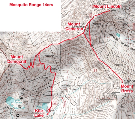
On July 21, I left my house at 4:30am to redrive back to Alma and climb Mt Democrat, Mt Lincoln, Mt Bross, and Mt Cameron.

I was an expert in Kite Lake parking and wasted no time in finding a legal spot and carefully locking the doors using the car keys I held carefully in my hand.  Then I took off for Mt Cameron and the rest.  My plan was to do the other peaks first, and then, if the weather held, reclimb Mt Democrat so I could say I did them all in a day.

And, I was new to the 14er game and didn’t understand why Cameron wasn’t really a 14er when it was clearly higher than 14k feet. So, I decided, to hell with the establishment that can rule a 14er is not a 14er.  I would hit it twice before the day was done, and I would count it both times.  And, henceforth, I would measure my progress using the 58 14er list which included 4 peaks over 14k that do not measure up to the standards set by the 14er accountants.

Mosquito Range 14ers route map from Kite Lake

1) Mt. Cameron:

From the parking area, I followed the road past the lake and began the boring hike up the pile of rubble to the Democrat/Cameron saddle. From the saddle, I hiked northeast along the right side of Mt. Cameron’s west ridge. Near 13,500, I regained the ridge and continued until reaching the flat summit area.  A short hike took me to the Cameron summit (#1).

2) Mt. Lincoln:

Without stopping, I left Cameron and descend northeast toward Lincoln; the path was easy to see. The last little bit was rougher but still easy, and then I was standing on the Lincoln summit (#2).  There was another fellow there who left shortly after my arrival.  I took my time to enjoy the good views I had from Lincoln, but then I remembered how quickly the weather can change.  I took off after my new acquaintance, since he seemed to be heading toward Bross, about 1.5 miles away.

3) Mt. Bross:

I hiked southwest back to the Cameron-Lincoln saddle, and then turned south and followed a nice trail towards Mt. Bross. My pace was good and I was steadily gaining ground on my “rabbit.”  I reached the Cameron-Bross saddle (~13,800)’ and headed southeast heading straight for the summit.  I caught up with my “rabbit” just before the summit of Bross (#3).  We chatted and laughed a bit about our “race” before I said my farewells and got up to leave.  I still wanted to do Democrat before the weather hit.

4) Mt. Cameron:

From the Bross summit, I tried to contour around Cameron to reach the Cameron/Democrat saddle, but the terrain was too loose and too steep, so I went only a little out of the way to pass over the Cameron summit once again (#4) on my way to Democrat.

5) Mt. Democrat:

From the saddle I continued west up the ridge. After climbing about 200’ along the ridge, the trail turned left and traversed southwest across the slope. I followed a few small switchbacks that lead to the top of the slope. I was starting to feel tired at this point, and apparently looked tired too.  Some hikers descending from Democrat consoled me with the news that the summit was near.

I couldn’t think of what to say so I just said “thanks” and continued to the Democrat summit where I had been the day before (#5).  I stood on the summit for only a minute because I wanted to do the circuit in under 4 hours.

A fast run/walk down the talus and dirt got me past the friendly hikers and back to my car at 11:15.  It took me exactly 4 hours and 15 minutes to hike 7.5 miles and ascend 3,700 feet.  And it even sounded like a magnificent accomplishment until I did some real climbs in the years hence.  But even today, I feel like it was a good effort, especially the part where I drove to Alma from Boulder twice in the same weekend.

To this day, my only mountaineering paranoia is the fear of losing my car keys.

See all trip reports

See all 14er trip reports