Posts Tagged ‘Alpine Rock’

Sharkstooth Sprint

July 18, 2013

July 13, 2013

The Sharkstooth taken on approach in July 1992

The Sharkstooth taken on approach in July 1992

I did my first rock climb of 2013 on June 30  and was amazed to discover that this latter-day cyclist missed his rock climbing days. It had been over a year since I had done any climbing on non-snowy or icy rock, and afterward I found myself actually moved to happiness simply by thinking of possible climbs to do this summer. And then, after a wonderful day in Eldorado Canyon State Park July 6th, my mind moved immediately to Rocky Mountain National Park (RMNP). I wanted alpine rock, and what better place to start than Sharkstooth (12,630′), the location of my very first alpine climbing adventure 21 years ago this July 10th.

In truth, I suppose I might have gotten ahead of myself a little bit.

The jump from moderate climbs on Eldo’s Wind Tower to RMNP’s Sharkstooth is a rather dramatic one:  a short walk from the car at 5200′ elevation for few 2-3 pitch climbs in the sunshine vs. a 5 mile approach in the pre-dawn dark over rough trail and talus gaining 2700′ to begin a 5-pitch climb that would take 4 hours to ascend another 650′ and 1 hour to descend for a 10-12 hour adventure. But I had done it many times before, and so it did not feel like foolish overconfidence to claim I could do it.

And Brian agreed with only the slightest hesitation.

Sharkstooth seen from Zowie

Sharkstooth seen from Zowie in 2010

With such a plan in hand, due diligence includes checking the weather report to understand whether the climbing window is wide, narrow, or closed for the targeted day.  The month of July is the height of the thunderstorm season for Colorado and its high peaks, and depending on our overall speed we would need 6 to 7.5 hours after first light to do it: a 30-60 minute talus hop through The Gash to the base of Sharkstooth plus a 30 minute climbing prep (including breakfast) plus 5-6 hours of climbing/descending to get off the mountain. And this not counting another 45 minutes would get us below tree-line, and out of the danger zone.

The thursday forecast was for ‘showers and storms starting at 9am’, but the friday forecast would rule for a saturday climb.  While waiting for friday’s report, below is a ranking of possible weather forecasts, from worst to best that I carried in my mind:

Storms starting:

  1. at or before 10am, meaning less than 6 hours to finish (nope; reschedule)
  2. at 11am, meaning about 6 hours to finish (everything goes perfectly plus we hike out in storm; take a chance?)
  3. at noon, meaning about 7 hours to finish (everything goes perfectly; go for it)
  4. at 1pm, meaning about 8 hours to finish (probably safe; definitely)
  5. at 2pm, meaning about 9 hours to finish (very safe; a no brainer)
  6. at or after 3pm, meaning 10 or more hours to finish (no weather risk at all)

On friday afternoon, the forecast improved to ‘storms starting mostly after noon’.  We decided to proceed and make every effort to start fast, maintain speed and finish safely.

This ‘go fast’ strategy required three tactics:

  1. get up very early to start hiking very early
  2. hike as fast as possible (i.e., hiking fast as possible in the dark)
  3. reach the trail-less talus right at first light (daylight needed for navigation) to avoid lost daylight
  4. be first on the rock to avoid having to wait for other climbing parties

Just to be safe, we decided on an extra early start to give ourselves some extra margin for age-related slowness now that we are both over 50.  We decided to meet in Boulder at 2:15am and drive together to the Glacier Gorge trailhead in RMNP for a 4am targeted hiking start. The only obstacle to starting even earlier was the need to have some daylight to navigate the giant talus field in The Gash below Sharkstooth; if we got there too early we would have to wait for the sun to catch up.

The Day

I got up at 1am and met Brian at 2:15am. After throwing my gear into his truck, we started from Boulder right on schedule and arrived at the trailhead (9,240′) a bit after 3:30am to find only 1 or 2 cars. We assumed they were left the day before by bivying parties since no one could be crazy or worried enough to arrive even earlier than us. After an bit of last minute dumping of extra gear and water to save weight (and needless suffering), we started up the star and moonless trail at 4am.

We made great time in part by not stopping to rest. It was about 5:15am as we approached Andrews glacier in the dark. Brian said, “headlights,” and my heart fell. Damn. As I looked to where he pointed, Brian said, “I wonder what they are doing up there?” They were way off the hiking route to Sharkstooth and seemingly headed toward nothing that we knew. “Perhaps they are planning a climb up that way,” Brian said hopefully, but without conviction.

Approach to the Sharkstooth via the Loch Vale trail and junction to Andrews Glacier & Pass

Approach to the Sharkstooth via the Loch Vale trail and junction to Andrews Glacier & Pass

The sky was lightening quickly and was sufficient to start across the talus when we arrived at 5:30am. The lightening sky also revealed a cloud filled sky.

It wasn’t long until we could see that they were headed toward Sharkstooth.  I said, “Let’s go faster.” And we did.

We used a patch of snow to gain a chunk of ground on the other party, and a short distance later, we passed them. They didn’t know the area, but they were not slow.  And now that we were showing them the way, we had to keep up the brutal pace. We did it. We arrived at 6am, about 15 minutes before they did, ensuring a clear path to the top.  When they arrived, we discovered they had started hiking at 2am and simply got lost in the dark.  One of the cars at the trailhead was theirs!

It is worth noting here that we only took 2 hours to hike 5 miles and ascend 2,700′ to reach the base of Sharkstooth. That is 2.5 mph and 1,350 feet per hour, with 20 lbs of iron in the pack.  That pace is off my personal speed chart and a full 50% faster than we managed almost 17 years ago as 34 year old men. With such evidence in hand, I am pleased to report that Brian has regained nearly all of his pre-illness strength, and that my increased cardio fitness (and lower weight) has held off the ravages of age for a bit longer than expected.

Pitch 1:

After changing into dry, warm clothes and consuming a bit of breakfast and 1 of 2 liters of water I brought for the day, I started up the rock at 6:30am, taking the most obvious dihedral.  My fingers quickly froze as I slowly worked past the wet vegetation, straight up to a large ledge directly below the slot marking the start of the 2nd pitch.  They key for us was to stick to the route we knew to minimize any lost time.  The sky was not yet threatening, but did look like it could rain in the next few hours.

Pitch 2:

Brian continued straight up until reaching a ledge at the top of the prominent left facing flake.  I followed the rope without much thought for route finding until I reached the flake.  I paused to decide whether to face climb the rock to the left (as I had done before) or simply layback up the flake.  I decided to do the classic layback to reach the belay in style.

Pitch 3:

View of Estes Park from top of 3rd pitch

View of Estes Park from top of 3rd pitch

I continued straight up the steep but bucket-filled terrain to reach a big flat ledge that marked the start of a recognizable arete. Every variation of the NW Ridge route must hit this ledge, as it is the first part of peak that actually forms a ridge.  The views are spectacular off both sides.  This was the longest pitch of the day, taking nearly the entire 200′ rope.

At this point, the clouds seemed to be thinning.  It seemed that we would get lucky with the weather, as we have so many times when we show proper respect.  Still, it looked to be raining in parts of RMNP, so we stayed alert.

Pitch 4:

Brian climbed up the off-width crack and belayed at the next large ledge below the white face.  I followed after taking many photos in a foolish attempt to capture the majesty of the views from that spot.

Pitch 5:

I took the last pitch, starting by moving left of the white face and climbing the rough rock toward the summit.  I stayed left to avoid rope drag, continuing past the next big ledge to belay a few feet below the summit level.

We untied and scrambled to reach the summit at 10:30am.  We enjoyed the views for a moment before heading down to get some water; it had been 4 hours since our last drop of water.  And, while the weather had held, we were still at least 1.25 hours from treeline.

Panorama from Sharkstooth summit July 2013

Panorama from Sharkstooth summit July 2013

The Sharkstooth rappels are always interesting for the questionable anchors; we sacrificed a sling on on the middle anchor where the slings looked particularly aged.  After downclimbing the final 70 feet, we scrambled down few hundred feet over blocky talus to reach our packs.  I found that the marmots had knocked my pack down from a ledge in a vain attempt to get my food (I had carried it with me).

View of Petit Grepon and Sky Pond from Sharkstooth rappels

View of Petit Grepon and Sky Pond from Sharkstooth rappels

We got back to the packs right at 11:30am.  With the improvement in the weather, we stopped to rehydrate and eat lunch before starting the long walk to the trailhead.  I finished my last liter of water and a couple Larabars.

The steep descent was brutal on my aging knees, but we kept up a good pace to get to treeline before any late arriving weather spoiled the day.  We continued back down the way we came up; I was dreaming of ice for my knees.

We arrived at the trailhead at 2pm for a 10 hour truck-to-truck roundtrip.

Not bad for two 51 year olds.

Timeline:

  • 1:00am – I wake up before alarm goes off after 3.5 hours sleep
  • 2:00am – leave the house for Boulder
  • 2:15am – meet Brian at 29th street mall and leave together for RMNP
  • 3:30am – arrive at Glacier Gorge Trailhead parking lot
  • 4:00am – start hiking toward Sharkstooth
  • 5:15am – see headlights ahead of us
  • 5:30am – arrive at turnoff for The Gash and The Sharkstooth; first light
  • 6:00am – arrive at base of Sharkstooth (15 minutes ahead of other party)
  • 6:30am – start climbing
  • 7:15am – finish 1st pitch
  • 8:00am – finish 2nd pitch
  • 9:15am – finish 3rd pitch
  • 9:45am – finish 4th pitch
  • 10:30am – finish 5th pitch; arrive at summit
  • 11:30am – descend to base; eat lunch
  • noon – packup and leave for trailhead
  • 1:00pm – arrive at Loch Vale
  • 2:00pm – arrive at trailhead and leave for home
  • 2:30pm – stop in Estes for ice
  • 3:30pm – arrive in boulder
  • 4:00pm – arrive home 14 hours after departure to hike 10 miles, ascend (and desend) 4000′ of elevation, burn 4000 kcal
  • 4:05pm – soak in hot bath until cooked and pruned
Advertisement

Dog Star on McHenrys Peak

February 18, 2010

Brian dug deeply into his copy of Rossiter’s High Peaks book of RMNP alpine climbs and found Dog Star (5.8).   When Brian introduced the idea, I was interested right away because I had long wanted to climb McHenrys Peak.  And I love the adventure of climbing up a big alpine wall; Dog Star is recommended in multiple guide books.  But this trip is documented here due to the epic nature of the climb, only partially caused by illness.

“Dog Star:  it’s a bit of both.”  … overall assessment put in writing by me on the following day

We started hiking from the old Glacier Gorge parking lot @ 4am expecting to make our normal fast pace, but I was off.  My body just wouldn’t cooperate with my cerebral wishes and its own best interests; but I suppose losing some of my altitude tolerance (spending 5 of 7 days in Atlanta for the last 3 months) and failing to get a minute of sleep the night before was just too much for my old body.

I hiked as fast as I could (read: slow), and we reached Black Lake a little after sunrise, around 6:30am.  We took our normal shortcut toward Arrowhead from Black Lake and worked our way up to the large triangular buttress that dominates McHenry’s northeast face.  At 7:30am, we stopped a few hundred yards below the face to study the rock and find our bearings.  While Brian studied, I slept.

Dog Star on McHenrys Peak

Once we started, it felt like we were off-route half the time.  And it wasn’t just me (sleepy head). We both seemed to spend much of the day figuring out where we were and trying to get back to the route.  Occasionally, we felt we were doing it right; but in the end, we were just glad to make it to the top.

It was good rock, except for the plant life; we just had to follow our nose and hope we didn’t dead-end.  “Faith” can be hard to come by, but without it, this day would have ended much sooner.

Our route up Dog Star. Pitches correspond to description below. Edited from Gillett original

Pitch 1: I started on a wide crack for 50 feet, then recognized a key feature to my right and traversed to get back on route; climbed up a giant detached flake and belayed on a ledge below a hard dihedral


Pitch 2: Brian climbed the dihedral, requiring a hard pull over the lip without holds. He then turned a bulge on his left (route description seemed to point to right bulge) and belayed at ledge above the bulge.

Pitch 3: It was my turn, but I was feeling nauseated.  Brian climbed up a slabby section to a ledge

Pitch 4: Determined to feel better, I started up a curving ramp and reacquired the correct route (I believe).  I belayed at big flake and felt bad enough to think death would be better.

Pitch 5: Brian climbed up a ramp to the right and continued around the bulge to his right and then up another right leaning ramp.  He belayed beneath a big roof & dihedral

Pitch 6:  Brian took a couple falls trying to free climb the bushy, mossy and, in addition, technically difficult roof.  It was rated 5.8, but I’ll eat my computer if that is accurate. He resorted to aiding it so we didn’t have to spend the rest of our lives there.

Brian recalls:

I angled up to the left on thin moves including a finger crack that held a solid cam.  It looked like there was a ledge above that, but when I pulled my head up over the edge, it was actually sloping quite a bit.  The finger crack was full of dirt and moss at that point.  I fell trying to pull over the edge, and after that we were a bit demoralized.  I stood on the cam to get onto the sloping ledge.  After that were some roof moves.  I remember that they actually had good holds and thinking that we could have free climbed them on a good day.  But after the fall, I just wanted to be done with the pitch.

Pitch 7: Brian led a rope length of hard, steep rock that took a bit of wandering to find the easiest climbing.

Pitch 8: Brian continued up the steep section to reach a left-leaning ledge, which he followed to reach the top of the ridge.  The correct route works straight up from the ledge, but I was ready to use a parachute to get off the rock.

Brian looks up at Dogstar with Longs, Pagoda & Chiefs Head in background

At the top, Brian waited for me to announce a decision on proceeding to the summit.  I hate missing out on a summit when I am so close, but I bailed.  If my leg was off, I would have tried. But nausea is an unfightable affliction. And I must have looked bad, too, because Brian took some of my half of the gear weight.

Heading downhill made me feel better, if only psychologically.  We worked down to Stone Man Pass, and then down the gully to reach the base of the climb.

It was over except for the clean up (the boring hike out).  We had done it, sort of.  I regretted missing out on McHenrys Peak’s summit, but I knew I’d come back eventually (in 2 years, actually: see McHenrys At Last).

We got back to the parking lot at 6:30pm for a 14.5 hour effort.

I cannot say I recommend Dog Star or mountain sickness.  But if only for the great memories, I do recommend aiming high.  A bit of suffering seems to make all the difference.

See all trip reports

See RMNP trip reports

Much Ado About Nothing on Chiefs Head

February 16, 2010

For eight years, one of the most significant rock formation in RNMP had stared us in the face every time we’ve ventured into Glacier Gorge, and yet, we’d never thought to venture onto its features.  Primarily, our lack of attention was due to the very long approach, but in some important way, its forbidding and committing look was also a deterrent.

The guidebooks didn’t paint a rosy picture, either.  Rossiter’s guidebook says…

The Northwest Face of Chiefs Head is one of the finest alpine walls in the contiguous United States.  The immense and unusally smooth oval face rises a thousand feet…and is home to some very aesthetic and very hairy routes.  All of the routes have long runouts and no fixed anchors[.] In the event of storm…it is very difficult to escape.

Plus, all the routes seemed to be 5.11X or 5.12R, so our attention was rightly elsewhere.  But one day, Brian sends me an email:

Joe:

How about “Much Ado About Nothing”.  This is about the only climb on Chiefshead that isn’t 5.10 or above.  It’s way right of the big wall, and has five pitches, with the last one 5.8.

Brian

My thoughts were along the lines of: Heck yeah!  Only 5.8, really?  Why haven’t we done it before now?  And we can bag another Chiefs Head summit! I responded via email with agreement and a question about the descent.  Brian replied:

Joe:

Descent may be most interesting part.  Stoneman could be done, but it would be a long way back to pick up packs.  Rositer recommends rapping down his Birds of Prey route, but first you have to find it.  And find it empty.  The third choice is a third class route much closer than Stoneman. Finding that route could be valuable knowledge.

Forgot to mention:  this climb gets no star in the book.  But I thought it would be worth it to do something on that mountain.

Brian

I wondered about the “no star” thing, but was already enthusiastic about the climb. They say, ignorance is bliss, at least for a while.  Soon, we’d find out just how wise it is to be afraid of Chiefs Head’s Northwest Face.  We find out just how hard Chiefs Head climbs really are, even a mere 5.8 route.

The Story

On the morning of August 23, 2003, we caught the 5am shuttle bus (earliest available) to travel up Bear Lake road as we set out for the far end of Glacier Gorge. We had to hike approximately 7 miles and over 3,000 vertical feet just to reach the start of the climb:  we hiked up past Black Lake, over the north shoulder of Spearhead, past Frozen Lake and beneath the west face of Spearhead, and then we scrambled up a rocky shelf before crawling up the snowy talus to reach the northwest face of Chiefs Head.  Then, we turned west and climbed up the snowy ramp to reach the base of the climb.  It was a brutal 3.5 hours; and we hadn’t even started the climb.

Our route plus alternative descent routes from Chiefs Head

Prior to reaching the base of the climb, we stopped for a moment of study while we could still see the entire wall.  The key was the figure of a head that would guide us to know where to start and where to aim during the initial pitches.  We were looking at shadowy patches trying to find one that looked like a head; Brian claimed to be able to see an “Indian’s head” but I could not.  But with a target in hand, we finished the approach.  Just before 9am, we started up the Much Ado About Nothing route on Chiefs Head’s Northwest Face.

Pitch 1

I took the first pitch and climbed over steep, broken ground that was supposed to end at the base of a “head” I could not see.  I could do no more than take out as much rope as I could and find a good spot to belay.

Pitch 2

Brian took the second pitch, following huge broken flakes that provided small left-facing dihedrals on their left side.  He finished over some easy ledges and belayed at the base of a left leaning ramp.  At this time we noticed that the weather was worsening; our view west was blocked, but the sky above was clouding up and darkening.  We knew we had to hurry since the crux was still ahead.

Pitch 3

I took the third pitch which was to climb the ramp leading up and left angling toward a big dark roof that stretched for more than a pitch as it arched left.  To save some time on an easier section, we decided to simul-climb. Using the ramp to travel diagonally under the  roof started out easy, but then steepened.

And then the rain started.  It was a only a drizzle, but now we were in it.  It was approximately 12pm.

The crux of the climb was still ahead; I knew we had to get past the slabby crux before the lichen turned into grease.  I put in a quick belay with about 1/2 a pitch of the roof remaining so Brian and I could put on our rain jackets. We then moved the belay to below the crux pitch so Brian could race the weather past the crux.

Pitch 4

Just as Brian arrived at the end of the ramp, the rain began again in earnest.  We could see the next ramp approximately 30 feet above us; Brian had to get there before the rock became unclimbable as well as unprotectable (a slab).  He started quickly but soon slowed as the  rock was quickly getting slick.

As I sat in the freezing rain, I could feel the water soak thorugh my rain jacket.  As I watched Brian slowly working his way up, hoping he wouldn’t take a long fall, and as I got colder and colder as my clothes became more and more wet, I came to understand just how important it is to have proper gear when venturing into hard to escape terrain.  Apparently, my windproof, water resistant, insulated and wonderfully packable North Face jacket was not up to the challenge of a real Alpine adventure.  I was going to suffer terribly as a result.

Brian decided to stop before the ramp, but after the hard section, to allow me to get past the crux before it became too wet.  But it was too late, the rock was completely drenched, and I was certain I could not climb the rock.  I was mentally prepared to “fall up” over the slick rock.

And it was like climbing a greased slope, but 3 points of contact allowed me to cling to the rock like a spider in the shower.  Once I reached Brian, we quickly moved the belay up to the ramp so we could figure out where we were.

Pitch 5

We were very confused because, according to the information we had collected, we should be at the summit ridge already.  But there was no summit ridge in sight.  It turned out that Rossiter’s topo only showed the unbroken portion of rock that was set into and below the full NW face.  We didn’t have any certain knowledge or clue as to how to get to the summit ridge.

All we could do was follow the ramp we were on and then follow our noses to try to find the rappel anchors or at worst take the summit ridge down to either Stone Man Pass or find the mysterious “broken ramp” that Rossiter described as an ascent route to the right of the Much Ado About Nothing route.  But first things first.

I took the lead for a simul-climb of the ramp.  After a couple hundred feet with no rap anchors or anything else looking promising, I found a right leaning ramp that promised to intercept the ridge as it sloped down. Desperate for any escape, I abandoned the search for rap anchors and took the right leaning ramp.  It went, and I was able to piece together a climb off the face.

Yes!  We made it.

While I was sopping wet and freezing cold, I now had control over my fate; I knew that I knew how to get home.  I just needed to escape Glacier Gorge before it got dark; it was approximately 3pm.

Much Ado About Nothing route plus descent. Photo from Longs Peak of Chiefs Head edited to highlight Chiefs Head features by removing other peaks (e,g,m Mt. Alice) from the background.


Descent

Shivering with no hope of getting warm, I had no intention of continuing to the Chiefs Head summit.  I wouldn’t have done it even if I had never stood on top of Chiefs Head.  I felt that my life was in play and wanted to take no unnecessary chances.

Brian thought he could find the gully that Rossiter described as an ascent route; from a safety, time & energy management perspective, we desperately wanted to avoid going all the way around to and down Stone Man pass.  We hiked down the much of the NW Ridge to find a likely big gully to descend.  It was more like a series of steep gullies that would work for 40 feet, then we would have to find ledge that would allow us to traverse to another gully.

We kept trying to turn back to the east where the climb started, but each time all we could see was a difficult ledge heading east and then a rock rib would prevent us from seeing whether the ledge continued.  Brian said it reminded him of Pyramid Peak.

Eventually Brian found a ledge that led out to the biggest rib, and from there he could see the start of the climb, and sloping, rubble-covered ramps leading down to it.  We scrambled down and followed it until the terrain started to break up; a path to the right appeared and we took it, hoping it would lead to the snowy ramp we started on.

We had to retrace our steps a couple times as we’d cliff out, and then we split up to double our chances of finding an escape path.  Eventually Brian found a path through tumble that worked.

It was approximately 5pm.  Three hours of light left.

We packed up our gear and headed down as fast as we could manage.  We were going to get caught out by darkness; it was only a question of how much hard hiking we had to do in the dark without headlamps.

We retraced our steps so not to introduce any new variables, and we made it to within a quarter mile of the Bear Lake road before it became too dark to see what we were doing.  Since the buses ran until 10pm, we took our time creeping in the dark to find the Bear Lake road.  Once there, we started downhill and found a small group of people standing by the road.  We confirmed that it was the bus stop and then we layed down on the pavement to wait for its arrival.  We had spent our last ounce of energy.

We made it.  We had hiked 15 miles, and climbed nearly 4,000′ in over 15.5 hours.  And this time we had overcome serious route finding problems, freezing rain, and one serious case of rain gear stupidity to make it home once again.

It was a glorious adventure.

See all trip reports

See all RMNP trip reports

The Long Way Up Longs Peak (Stettners-Kieners)

February 3, 2010

I love Longs Peak, and one of my unofficial missions is to climb a different route/season combination nearly every time I reach for the summit.

Next on the list was to reclimb the route used by the Stettner brothers (Joe & Paul) to climb Longs Peak on September 14, 1927, including the Stettner’s Ledges (5.8) route to climb from Mills Glacier to Broadway Ledge.  As they did, we’d also use the Kiener’s Route (5.3) to skirt the difficulties of the Diamond and reach the summit. Stettner’s Ledges represented the hardest multi-pitch alpine route in Colorado (and perhaps in North America) for the subsequent 20 years.

“We were familiar with two established climbing routes on the East Wall — Kieners and Alexanders. We studied them. But we wanted to find a new route. We searched for a route by starting at Alexanders Chimney and working our way to the right with the binoculars. With the help of these field glasses, we found a line of broken plates, ledges, and cracks that we could eventually use as a route. It looked challenging enough for us.”

~ Joe Stettner’s Journal, recounting the events of September 14, 1927

On the morning of July 17, 1999, Brian and I started up the the trail towards Long Peak, passing the Longs Peak Ranger Station @ 4:15am.  It would be my 6th different route to the summit of Longs Peak, if everything worked out.  The only thing I worried about was the weather report; we’d have to get lucky to reach the summit on this day.

My Routes (prior to 7/99) to the Longs Peak Summit

  1. The Diamond, Casual Route (7/94)
  2. Notch Route (6/96)
  3. Keyhole Route (11/96)
  4. Kiener’s Route (7/98)
  5. Gorrell’s Traverse with a direct finish of The Notch (9/98)

The hike in went as so many have gone before it….long but tolerable.  And, despite a serious attempt by a slippery trail to destroy my knee, we maintained a good pace and reached the foot of the climb by 7am.  I somehow managed to forget that Mills Glacier would be hard snow and didn’t bring anything to aid my ascent of the glacier/snow field to reach the start of the Stettner’s Ledges climb.

Stettner Brothers 1927 (dashed) & Joe/Brian 1999 (solid) Summit Routes

Aiming for the bottom of the obvious left leaning flake system, I used my nut tool as a make-shift ice axe and kicked steps when I could and otherwise crawled to ascend the shockingly steep Mills Glacier.  During this ridiculous episode, I stole a moment every now and again to think how this was a really stupid way to ruin a day, a season, or worse.  My relief was palpable when I finally reached solid protection from a long slide to the bottom of  Mills Glacier.

Looking back on our approach around Chasm View Lake

Stettner’s Ledges

1st Pitch

Brian took the first pitch.  It was a 140-150′ long climb angling somewhat left over many flakes and cracks with a few pitons to guide the way.  He found a nice ledge for our belay.

2nd Pitch

I took the second pitch that started with a step around a corner and involved easy climbing over some blocks to reach a good belay at a right facing large flake (5.5).

3rd Pitch

Looking up, we could see a series of pitons jammed into an overhanging dihedral protecting a steep climb over thin holds navigating a robust layer of slime.  The water trickling down from The Notch was feeding an aquatic ecosystem that looked like it would be protected by Boulder’s Open Space & Mountain Parks organization if located a few miles further east.  I tried to help Brian’s psyche by suggesting he could aid the climb if it was as bad as it looked.  Right.

Brian on Stettner's Ledges

Not one for delaying the inevitable or waiting for government intervention, Brian took off to figure it out (in proper Paul Stettner fashion).  After a moment of sitting, I noticed that the sun was gone; I was stuck in the shadows and my body temperature was dropping quickly.

I got small to preserve my body heat while I waited for Brian to swim up to the next belay and free me from my static duties.  The conditions demanded a slow climb, but my suffering was all out of proportion to the hour it took for Brian to finish.

Climbers Rule of Variable Time Passage

“The rate at which time passes for a climber is directly proportional to the level of preoccupation for the climber and inversely proportional to the level of suffering and pain endured by the climber. “

And to make matter harder to endure, it was during this pitch that the rockfall barrage begain.  I don’t know if it was climbers (I think it was although no one yelled, “rock” ) or merely natural falling rock from freeze/thaw action (the Stettner brother wrote of rock fall here in 1927), but it was damned unnerving to have such volume of rock crashing down the rock within 10 – 20 feet of my head.

When it was my turn to climb, I was so stiff and my hands so useless I didn’t think I could climb the 3rd Flatiron.  But the body can warm up quickly when the stress is right.  I followed Brian’s path through the slimy ecosystem, taking huge sections of it with me on my clothing.  When I reached Brian, I could see he had taken a hit to his nose somehow.  It was now a “blood” adventure.

4th Pitch

I traversed left onto the Lunch Ledge after mounting a steep flake system which felt harder than the rated 5.5.  When I reached the end of the “Lunch Ledge”, it was obvious that we needed to make a team decision about how to proceed.

5th Pitch

I brought Brian up and then we took a few minutes to look for the direct line (Hornsby Direct variation).  The rock was very confusing, and we just couldn’t spot the correct path out of the many options above us.  We reasoned that we needed to hurry given the weather report and our plan to continue to the summit. We decided to find the easiest, quickest path to Broadway Ledge: The Alexander Chimney route. (Note:  we also thought that this was the original line of the Stettner brothers, but that has since been refuted; the original line took a direct path, probably the Hornsby variation).

Even still, the path wasn’t obvious.  Brian followed his nose, generally left and up over ledges and around corners.

6th Pitch

The final pitch was mine.  I couldn’t figure out what I was looking for and eventually tried to climb a dihedral that didn’t quite work.  After a downclimb I finally found something that looked like the Alexander’s Chimney finish, but ran out of rope without a belay spot in sight. I waited for Brian to take down the belay and then we simuclimbed the last 40 feet to Broadway Ledge.

It was a struggle, but we made it.  And we did it without falls, but it took us 6.5 hours compared to the Stettner brothers 5 hours.

“With great trouble, we fought our way upwards. Time-wise, it appeared that we would have to retreat.  The wall was approximately 1,600 feet high and, besides being steep, it had many overhanging sections.”

Yet, despite multiple falls held by a hemp rope (static) they bought at the Estes Park General Store (“Though not the best, it ought to fulfill the purpose”) that was merely tied around their waists, the Stettner brothers reached Broadway Ledge after 5 hours of climbing.

~ Joe Stettner’s Journal, recounting the events of September 14, 1927

Traverse to Kieners

We followed the Broadway Ledge to the Notch Couloir, and then to the far edge where we knew at least one variation of the Kiener’s Route that worked.  We were on terrain we knew, but it was late on a day with a threatening weather forecast.  But, with the weather still holding up well, we figured it was better to run up terrain we knew than to try to rappel down to Mills Glacier without a known rap route.  And descending via Lambs Slide was completely out of the questions without crampons and axes.

Kiener’s Route

“Walter Kiener, a climbing guide, pieced together this route in 1924, looking for the easiest way up the east face with an eye toward future clients. Very little new ground was covered on the ascent. It’s possible he did this over several visits, with help from Agnes Vaille and Carl Blaurock. Another guide from this era, Guy C. Caldwell, installed cairns all the way up the route and advertised his services in the Aug 7, 1925 issue of the Estes Park paper”

~ Bernard Gillett, The Climbers Guide: High Peaks, 2nd edition (2001)

Our Upper Kiener's Route

To save some time, we decided to simul-climb the low 5th class section.

We started straight up through the broken rock and over a chockstone, and then into a narrowing chimney which we took to its end, and, then, up a waterfall to a big, grassy ledge.

Past the 5th class climbing, we unroped to make fast time up the 700 feet of talus and gullies.

We knew from previous experience to aim for the edge of the face and look for the “Black Bands” of rock.  When we finished climbing over the long section of giant steps, we moved to the edge of the Diamond to turn the corner and reach the east talus slopes.

And after scrambling the final 200 feet of talus, we reached the summit at 3:45pm; my 6th Longs Peak summit was in the bag.  We had climbed the 1600′ of elevation between Broadway Ledge and the summit in 1 3/4 hours; its good to see we can pickup the speed if we have to do so.

Our weather luck had held out, but we still had to get down.

Descent

We chose the Cables Route, as always, for its direct approach to the Boulderfield.  The path is easy to follow since we’d done several time before, except this time the path was blocked by a large snow patch covering the last 100 feet above the rappel anchors.

Crap.

Fortunately, this snow had been in the sun all day.  But the terrain was steep enough that it wouldn’t take much of a slip to generate the speed needed for air travel.  We carefully kicked steps and jammed exposed fingers into the snow…anything to get a little friction.  By the time we found the first rap anchor, my fingers were frozen stiff.

Then it started to rain.

Combined with the approaching darkness, we didn’t need any additional encouragement to hurry once again. A quick pace down that death-march trail got us to the Ranger Station by 7:45pm for a 15.5 hour round trip.

The best adventures always include some amount of overcoming or dodging serious setback, such as:

  • A smashed knee
  • Missing ice gear
  • Rock fall
  • A bloody nose
  • A route finding error
  • Threatening weather

And this trip was a great one.

See all Trip Reports

See Longs Peak Massif Ascents

2 Classic Climbs: Northcutt Carter & Petit Grepon

January 5, 2010

It was one of those things that gets into your head and you just have to do it.  When I first heard of it, I wanted to do all or at least a lot of the 50 climbs listed in the Fifty Classic Climbs Of North America (a climbing guidebook and history) written by Steve Roper & Alan Steck in 1979. Out of all the climbs in North America, the best 50; the ultimate tick list.  Since two of them were within my reach as a climber and nearby my house (in Boulder), I wanted to start as soon as possible.

The Colorado Climbs within “The Fifty”

  1. Hallett Peak, Northcutt-Carter Route III 5.7 [1956] (in RMNP; top of my list for a while)
  2. Petit Grepon, South Face III 5.8 [1961](in RMNP; had done once before)
  3. Longs Peak, The Diamond, D1, V 5.11 (in RMNP, but too hard; did “Casual Route” instead)
  4. Crestone Needle, Ellingwood Ledges III 5.7

Brian wasn’t crazy about the list (he is too anti-establishment to follow someone else’s list), but he did want to do the Petit Grepon and was willing to re-do Northcutt Carter; so, for next two weekends in 1997, we agreed to focus on 2 of the 50 classic climbs: Petit Grepon & Northcutt Carter.

Petit Grepon (August 30)

It probably wasn’t the smartest plan, to climb the most popular rock climb in RMNP on the busiest weekend of the year (labor day). I guess we just didn’t think of it in time to start the “classic” program earlier and couldn’t wait any longer with the changing season. And, the Petit climb is long enough (8 pitches = 5-8 hours, depending on difficulty and avg length of pitch) compared to the daylight hours before the probable rain (7am to somewhere between noon-2pm = 5-7 hours) such that we had to be first on the climb or expect to fail. [Note: learning to climb faster was another option, but it would take too long to get ready.]

Another complication was the planning for the descent.  The details we could find on returning to the base of the climb were too vague and included ugly descriptions of a “death gully”. So we agreed to escape over “The Gash” as I had done a few years earlier with my CMC rock climbing class, and descend down the Sharkstooth approach.  But, this meant we had to carry everything with us on the climb. It is never ideal to carry everything up the rock, but sometimes that is the best or only way to do it; the obvious key is to not bring too much.

The fact that we couldn’t get a bivy permit worked well with this detail.  We bring very little, start very early, and blast up the trail to be first on the rock.  In reality, we figured we’d be tip-toeing past the sleeping climbers to beat them to the rock. It was a great plan.

We hit the trail at 4am and got in line.  It was crowded like I had never seen it before in the pre-dawn hours.  We put it into high gear and passed everyone and got to the rock ahead first.  One group of sleepy climbers tried to pull themselves together quickly as we passed by, but it was too late; we were first on the rock. “I love it when a plan comes together.” (Col. John “Hannibal” Smith, A-Team)

Our path up the South Face route (III 5.8) of the Petit Grepon. We descended over "The Gash" which is directly behind the Petit Grepon, between the Sharkstooth and the Saber, from this vantage point.

To make sure we stayed in front, we skipped the initial pitch by scrambling up the west-side talus to reach a ledge which we used to traverse back to the South Face III 5.8 climb.

Still in a race to be first or at least not hold up anyone else, we quickly got ready for the next part of the day.  After putting on more clothing (we wouldn’t be burning calories like we did on the hike in) including rock shoes and harness, organizing the climbing gear & ropes, and eating a quick breakfast (a couple bits and a swig of water), we packed away everything else we brought into our small packs.

And, then, without another glance back at the climbers jostling for position, we started up.

Pitches

  1. Traversed right to reach the giant chimney in the center of the face
  2. Exited the “cave” to the left and climbed to a large ledge below another, but smaller chimney
  3. Climbed the chimney, then traverse right to a belay below the right end of a roof
  4. Moved right and then climbed a steep crack, into a left-facing corner with a finger crack (crux), and continued up and right to a ledge on the east side of the Petit Grepon
  5. Climbed up, then right and then left to a small stance on the southeast arete.  I believe this spot is called the “Pizza Pan” belay
  6. Climbed a crack above the belay to a ledge, and then up the wall. Belayed on ridgeline
  7. Followed the ridge to the teeny tiny summit
  8. Enjoyed the spectacular views of the world from the sofa-sized summit while resisting an urge to lay flat on the rock

It was incredible; the summit was a 10×30 diving board offering lots of air time before the sudden end.  The summit was so small that I had to look at my feet when I stood upright to keep my balance; the ground was outside of my peripheral vision.  And the fear of falling off was somehow magnified by this phenomenon.  When I sat down, I thought I could feel the rock swaying, which brought on fears of the rock breaking off.  It was the coolest place I’ve ever been, and getting down right away felt important and promised to be interesting.

A profile view of the top 1/3rd of the Petit Grepon from behind. It is a really disconcerting sight that forces you to wonder if it might break off!

We looked around for rap anchors and found a good set on the back side (NE corner).  We then scrambled up a deep chimney to the north to reach the Sharkstooth side of “The Gash.”  From there we descended back down the Sharkstooth approach.  Once we reached the the Loch Vale lake, we found the crowds again; the trails were packed elbow to elbow; it was horrific.  Welcome to Labor Day weekend at RMNP.

But the weather stayed perfect the entire day:  clear skies, warm temperature, no wind, and after 11 hours, we made it back to the parking lot.  We got back so early that a Ranger questioned us intently to see if we had done an illegal bivy.  All we had to do was point at our tiny packs to prove we didn’t do so.

One classic down, and one to go.

Northcutt Carter (September 6)

Then it was time for my test-piece.  And I was scared for a number of reasons.  At the top of the list, the route was famous for route-finding disasters; a rating of 5.7 was only true if you could stay on route. Undoubtedly, the actual difficulty would be harder.  Another was that I had never climbed on Hallett Peak before; I just hadn’t worked up the courage yet. If I could overcome my fear and successfully climb Northcutt Carter, if I could pass the test, then I could call myself a real climber.  Well, that’s how it felt, anyway.

To combat the legendary route-finding difficulty, I studied my copy of Bernard Gillett’s High Peaks, 1st edition (the importance of this detail will become clear later) more carefully than ever before.  And, of course, I made a photocopy of the topo and route description to remind should I become confused.

Just as the week before, we were planning on climbing a very popular route.  And this time, the weather report promised bad weather in the afternoon.  We needed to get an early start and move fast to make it.  Yet, since the approach was far shorter, we slept in a bit; my alarm didn’t go off until 3am.

We hit the trail from the Bear Lake parking lot at just after 5am and took only 30 minutes to reach Emerald Lake.  It was still dark so we couldn’t see how far we had to go.  I thought we might have started too early, but we didn’t reach the bottom of Northcutt Carter until 6:45am.  And once again, we were the first to arrive; and we didn’t waste any time getting started by scrambling up the broken rock to the right of a break in the “white band” to reach the bottom of the climb.

Pitch 1

Brian took the first pitch, and climbed a corner for about 1/2 a rope before moving a bit left and climbing up a slabby rock.

Pitch 2

We were swapping pitches, so the 2nd pitch was mine.  I took out my topo for a quick refresher; Gillett said, “go straight up a crack, then move a bit right to the belay.” Unfortunately, the guide book was wrong!  Mr. Gillett was describing what Rossiter calls the “Faux Pas” route…a common mistake on Northcutt-Carter.  Of course, I didn’t know this until I later bought a copy of Rossiter’s book.

As directed by Gillett, I started straight up and then passed a roof.  It was pretty hard (turned out to be 5.8), so I figured I did something wrong; the pitch was only rated 5.4.

As I looked up I could see a couple pins with some gear left behind.  Booty!  I scrambled up to claim it without a thought to why someone would have bailed at that point.  And then it started to really get hard.  With the rock still a bit wet and the terrain now a bit overhanging, I was in trouble.

I kept making progress, but I was wearing out.  I found an unlikely leg jam that I could hang on with no hands.  That gave me a life-saving rest.

The rock was overlapping plates of rock like tiles on a roof…the pieces of rock were loose and the downward slope of the rock plates didn’t offer much to hold on to.  While I struggled to find the right piece of gear, one of the loops on Brian’s gearsling broke and sent the two large cams into oblivion.

Running out of gear and strength, I took to hanging on the pro to gather enough strength to make it another few feet.  But eventually I made it.

After Brian came up, we both were very confused about the route.  We couldn’t begin to think of how we got off-route.  But since the belay looked right, we decided to push on.

Pitch 3

Brian took the third pitch.  The rock all looked similar (the reason for the route-finding difficulties for many); following his nose, he took the original line of Northcutt-Carter, which was a bit to the left of the route we were trying to follow.  We had to simul-climb a bit so he could reach a good anchor.

Pitch 4

I had no idea where the route went.  I continued up the line until I got to a good belay stance in an alcove; the route didn’t seem to go anywhere from where I was; I hoped that Brian could find the route.

Pitch 5

Brian thought he knew where to go and traversed far right to link up with the route.  Once at the belay together, we both felt confident we had re-acquired the route.  This was the good news; the bad news was that the rain had started.

Pitch 6

I continued up toward a chimney and then climbed the chimney.  I saw a great belay spot and got to within 3 feet of it when I ran out of rope.  I had to jam my foot in a crack for balance while I struggled to find a place for one of the last pieces of gear remaining.  I then clipped a long sling to that questionable piece of gear and lowered myself to a sloping ledge where I could find a good placement for my last cam.

My anchor contained 1 good cam, a questionable tricam & my ass on a ledge; I wasn’t happy, but I was out of options.  I gave the rope 3 tugs and hoped Brian wouldn’t fall on the slippery rocks.  I sat in the rain wondering how we would get out with our lives.

Brian didn’t fall.

Pitch 7

Brian slowly crept up the wet rock while I froze in a freezing rain.  By the time he reached the top, I was a stiff, wet fool.  But since Brian was at the top, we were going to make it…I could just fall up the rest of the way.  Retaining a bit of pride, I managed to reach the top without resorting to falling.  And once I started to thaw out, my fingers hurt like the devil was eating them.

Descent

The descent gully was very hard to find.  Brian had been in it once the year before but I had never been on Hallett’s north face.  We eventually found something awful that Brian was certain was the right gully, and we started down.  I didn’t believe we were in the right place until climbers descending above us nearly killed us in a rock fall. Eventually we reached the bottom and spent 40 minutes fruitlessly looking for the fallen gear.

After a fruitless search we gave up and hiked out to go eat.  We reached the car at 7pm for a 14 hour day, and then went into Estes Park for a Mexican Food celebration.  I felt that I had accomplished something important, but that was the end of my obsession with the Classic 50; just too many great things to do close to home.  And, while 2 of 50 isn’t really a great accomplishment; not finishing the list at all seems to be rather common.  According to Wikipedia, no one has ever done all 50; perhaps everyone has too many good things to do nearby home.

That was also the end of my use of Gillett’s guidebook; I’ve used Rossiter’s book ever since.  I’ve heard that Gillett fixed that mistake in his 2nd edition, but I wouldn’t know for sure as I never bought it; some mistakes are simply unforgivable.

It is worth noting that it was good that we got Northcutt-Carter done when we did.  A few years later (I believe 1999), the bottom 2 pitches fell off the face into a pile of rubble at the base of the climb.  Northcutt-Carter was dead.

Hallett Peak with "dead" Northcutt-Carter route indicated

See all trip reports

Sharkstooth: My first RMNP love

January 2, 2010

The Sharkstooth taken on approach in July 1992

Sharkstooth.  My first RMNP love.

The Sharkstooth is well named.  It is the highest (12,630′) of the Cathedral Spires group of pinnacles on the ridge that splits the Loch Vale area and separates the Sky Pond/Taylor Glacier area from the Andrews Glacier area. When viewed from below Andrews Glacier, it looks like a massive tooth jutting up from the jaws of the Earth. It is located just east of the Continental Divide and Taylor Peak, and is a stone’s throw from the popular Petit Grepon.

In July of 1992, the Sharkstooth was the very first alpine climb I ever did, using the Northeast Ridge (II, 5.6) route. At the time, the 5 mile approach in darkness and 6 pitches of technical climbing for a total of 3350’ in elevation gain over snowy rock were far beyond anything I had ever experienced to that point in my life. I honestly felt I might not survive but thought the experience would be worth the risk. Adding to the allure, I was told that Sharkstooth was the only officially named peak (i.e., name is on map) in RMNP that required a technical climb to stand on the summit.  It seemed the perfect candidate to be the only peak I would ever summit, and I planned to brag about it for the rest of my

Me and a couple buddies on the Sharkstooth summit in 1992. From left to right, Mark, Jim, Joe

life. Fortunately, survival was not an issue; and in the months that followed, I couldn’t stop thinking about climbing more peaks.

My inevitable return visit to Sharkstooth occurred in October 1996, and was the first climb I ever did with Brian. It was a freeze-fest due to the late season effort that concluded with a 4pm summit, leaving only 2 hours of light to rappel down and hike out (in case you don’t know, it takes at least 3 hours).  And we didn’t bring headlamps.  As you may guess, it was another epic experience, cementing the Sharkstooth’s place in my heart.

Despite being my first RMNP love, so many peaks to climb meant it would take 3 years before we’d return once again; and this time, to complete the North Face [5.8] route, the key factor in success would be perseverance.  Return trips would come much more quickly, out of necessity.

The Climb

After digging deep into Rossiter’s guidebook, Brian had the idea of climbing the obscure North Face route [III, 5.8] which starts at the popular Northeast Ridge route but then spirals up and right around to reach the summit from the west side.  And on August 29, 1999, we set out to climb Sharkstooth once again.

We drove into RMNP in the predawn twilight and parked at the now extinct Glacier Gorge access parking lot.  With a quick sorting of gear, we were hiking at 5am.  We kept up a good pace and reached the base of the climb at 8am to find the rock wet & very slippery.  Our only hope was that the wind would dry the rock before the climbing got too hard.

Progress made in initial attempt of North Face route on the Sharkstooth. Photo from 1992 climb.

From the start, we knew it was going to be an adventure.  Rossiter’s description of the route was more like a set of tips than detailed description of the pitches he generally lays out:

“Climb the first pitch of the Northeast Ridge route, then traverse right to the higher of two grassy ledges.  Work up and right onto the North face following the easiest line. Continue in a spiral onto the West face until it is reasonable to climb directly up to the summit. Beware of climbing too high on the North face before rounding the Northwest arete; follow the line of least resistance.”

Essentially, he says to start at the SE Ridge route and go up and right. And the topo didn’t help very much either, as it just showed an arrow pointing around the corner of the NW arete.

But that is okay; more adventure for us.  We enjoyed and were good at route-finding.  We just hoped we had time for that sort of adventure.

Route-finding Rule of Fun

Good Route-finding Skills plus Enough Time

=  Fun Adventure

The first couple pitches were clean rock alternating with grassy ledges which brought us to the shoulder where we could see the north face above us.  That was our last sunlight for the day.  An ascending traverse right over broken terrain took us to the far right base of the north face.  And by 11am, I found a windy belay perch on a ledge from where we could peek around the corner and see the steep unlikely-looking west side.  This spot was about 150 feet short of the summit (2 short pitches).

And a few drops fell.

In a valorous effort to intimidate the weather, Brian ignored the mosture and started up the pitch.

Brian adds the following details regarding the crux pitch:

I led over couple blocks, then onto a grand piano sized flake.  It seemed like something we didn’t want the rope connected to.  After some more traversing past a grungy flaring chimney, I could see the slope start to ease off above me.  A couple more moves, and then I had my chin and a bomber brown tricam right at the crux move.

All I had to do was pull over onto easier ground.  Unfortunately, the rain drops that I had been denying were now becoming very insistent.  I could see that we still had more than a pitch to go, and while it was less steep, it was also thin on protection, and getting wetter by the second.  I must have been staring at it quite a while, because Joe politely yelled up that it was obvious we would have to bail, so why was I just standing there getting both of us more and more soaked…

We were fortunate to have the double ropes that day.

I think he was tempted to push it, since he was so close; but since we were in a good position to retreat back down the path we had taken, we had to take the only safe option.  If we continued up our spiral route but didn’t make the summit, we’d probably have no choice but to try to rappel into the gully below us, between Taylor and Sharkstooth.  And since we didn’t know if such a rappel was possible or how dangerous it would be to escape from that gully if we reached it, well… it was another time for a bit of discretion.

  • “Courage would fight, but discretion won’t let him” — Poor Richard’s Almanack, B. Franklin (1747)
  • “The better part of valour is discretion, in the which better part I have saved my life.” — Falstaff in Henry IV p.1, W. Shakespeare (1597)
  • “Than as wyse and discrete he withdrewe him sayng that more is worth a good retrayte than a folisshe abydinge — Jason, Caxton (1477).
  • “Bravery consists in foresight” — Suppliants, Euripides (510)

Brian managed to escape his position losing very little gear.  Then we backtracked around the North face and rappelled down the east face to our packs and the hiking terrain. And after the long, wet hike out, we reached the parking lot after a total of 11 hours of fruitless labor.  It was only the 2nd time either of us could remember bailing on a climb; we agreed that we’d come back soon to complete the effort.

Attempt #2

The approach to The Sharkstooth

We had tentatively set September 12th as the return trip, but the weather didn’t cooperate.  In fact, on the 11th, we decided to climb at Eldorado Canyon State Park due to the forecast; but at the very last minute, we decided to go for it.  We were worried about losing the season and not being able to finish until the next summer.

To give ourselves a better chance of beating the rain, we started hiking at 4:30am. Unfortunately, the rain started @ 5am.  It is a strange experience to hike in the dark while it is raining.  My initial reaction was, of course, disappointment; but quickly I realized that it was early enough to go back to Eldo and still get a full day.  Brian again convinced me to press on with the reasoning that the rain might stop and the rock would eventually dry.

The rain didn’t stop until we reached the base of the climb at 7:30am.  We sat for a minute to ponder our fate, but the cold temperature and wet conditions had us shivering before long.  We decided that it was possible that we could climb up the decent route,  and quickly started scrambling up to the start.  On such a bad weather day and with our early start, we correctly guessed that we wouldn’t be in anyone’s way.

Once we reached the descent gully, we could see it was full of snow.  Rather than give up, we decided to climb in our hiking boots. We knew the rock from previous visits and knew we could bail at any time.  And while the climbing was slick, we progressed steadily and reached the summit by noon.  We both insisted on a stop for lunch, and as we ate and shivered, we enjoyed our latest “alpine” experience.

The descent was uneventful and we arrived back at the parking lot after a 10 hour effort.  On the drive home, Brian made sure I understood that we had to go back to finish the North Face route.  Who was I to disagree?

Attempt #3

Against all the odds, the RMNP rock climbing season stayed open for another week (actually two additional weeks, but that is another story).  With a good weather report, we set out for Sharkstooth once again on September 18, 1999.  To give us an even better chance for success, we started hiking at 4am.  This meant we’d be in darkness for nearly all of the approach, but we absolutely didn’t want to miss what was almost certainly our last chance for the next 6 months.

The completed North Face route on The Sharkstooth.

Hiking over broken ground in the dark is hard, but we knew the trail better than most after 3 trips in the last 4 weeks.  And we almost made it without mishaps except for an overhanging rock that clipped my cheekbone as I sped by while my headlamp and attention were focused on my footing.  But without a serious delay we still reached the base of the climb at 7am…and we found beautifully dry rock.  Oh, the joy!  Our goal was to complete the climb by 11am, which was the time of the rainfall that ended our initial attempt.

We knew the initial pitches very well and cruised up quickly.  The last two pitches were very interesting…and hard.  It was my opinion that if we had pushed it on our initial attempt, we’d have gotten into serious trouble.

We reached the summit at 11am and enjoyed the fruits of Brian’s persistance.  Unfortunately, when we tried to leave, we had to share the descent gully with a team of 6 climbers climbing up the East Gully route (5.4). Through excruciatingly slow movement and brain numbing care, we managed to avoid knocking down any rocks or pebbles and made it back to the base of the climb and our packs.  A very fast hike back (1 hour 40 minutes) got us back to the parking lot in time for some guiltless football watching.

As they say, “Persistence Pays.”

“Nothing in this world can take the place of persistence. Talent will not; nothing is more common than unsuccessful people with talent. Genius will not; unrewarded genius is almost a proverb. Education will not; the world is full of educated derelicts. Persistence and determination alone are omnipotent. The slogan “press on” has solved and always will solve the problems of the human race”

~ Calvin Coolidge

See all trip reports

My First 14er: Longs Peak via The Diamond

December 30, 2009

…being too smart is no excuse for missing out on the chance of a lifetime.

~ me

It was the summer of 1994, and I was desperately looking for an adventure to fill the long July 4th weekend. I was new and late to the rock climbing obsession having started only two years earlier at the age of 30, but I had it bad. And, as far as obsessions go, this was more like an addiction.  Sure I liked it, but more to the point, I had to have it.

I was living in the Lincoln Park area on the north side of Chicago and was earning my climbing stripes in Baraboo, WI at the Devil’s Lake Bluffs and at the Mississippi Palisades State Park near Savana, IL. These climbing areas were 3 hours away from Chicago, so rock climbing was a weekend-only affair. And with wet weather haunting so many of the warm-enough days in that part of the country, I averaged only a few days a month. Constantly suffering from withdrawals, I regularly resorted to bouldering on the stone structures in Lincoln Park just to take the edge off.  My favorite was the black (dirty?) stone structure  housing the statue of Ulysses S. Grant (see more recent photo); it had a few surprisingly good routes, all about twice my height.

For the 4th of July, the obvious answer to the question of “what to do?” was to go to Colorado again. And the hardest, biggest, baddest climb I’d heard of in Colorado was The Diamond.

The Diamond is the sheer and prominent east face of Longs Peak and named for the shape of the cliff. The face has a veritcal gain of more than 900 feet all above an elevation of 13,000 feet. It is a world famous "big wall". The easiest route on the face, the Casual Route (5.10-), was first climbed in 1977.

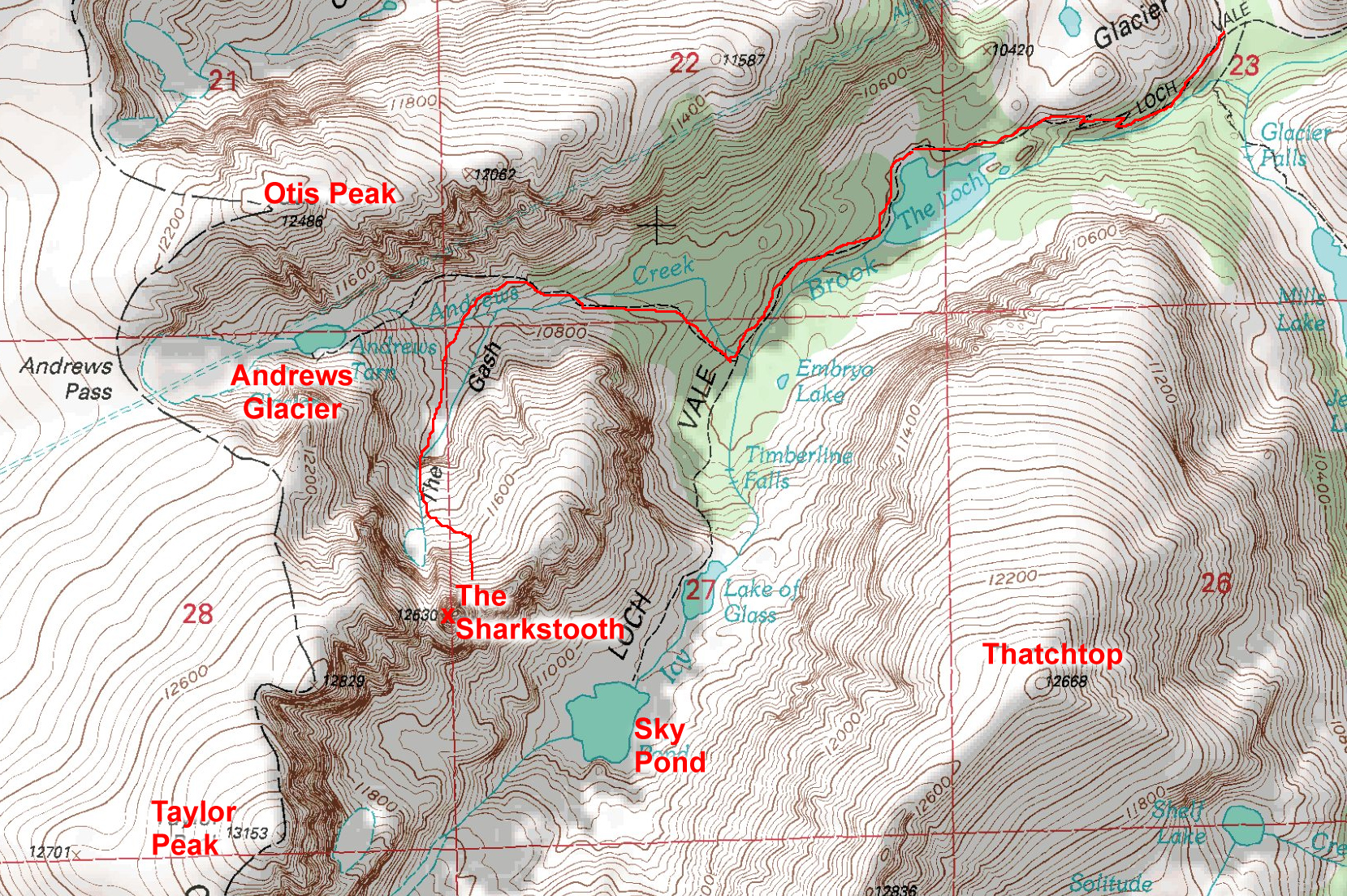
I learned about The Diamond during my two previous visits to the Colorado Mountain School (CMC) in Estes Park, CO. My instructors/ guides (Mike Caldwell, the dad of the famous climbing Caldwell, Tommy, and Topher Donahue, the son of the CMC Founder) led me & my pals up graduation climbs in RMNP (Sharktooth [5.6], Petite Grepon [5.8]), which always had that wonderful sense of being the absolute limit of human capability.

These fantastic “near death experiences” always led to discussions of “what was the hardest” RMNP rock to climb; the answer was always The Diamond on Longs Peak.

My Midwest climbing pals, whom I’d met at the Colorado Mountain School, would scare each other regularly with threats of “signing up for The Diamond”. We had a shared sense that The Diamond was just out of our reach where failure felt deadly. Looking back, I think  “The Diamond” served as our inspiration for improving our skills, both physical and mental.  We didn’t dare do easy (for us) climbs when we might be forced, through peer pressure, to climb the Diamond at some point in our near future.

Joe, Mark & Jim at the Mississippi Palisades and on the summit of The Sharkstooth.

The Spring of 1994 had been especially rainy, particularly on weekends (it seemed). My climbing-withdrawal induced insanity lead me to think the unthinkable.  And, after a few days of hard self deception, I had myself believing that I could handle the 5.10- climbing and 14,000 feet of altitude.  To do so, I had to put two disturbing facts out of my mind:

  1. I had never climbed anything harder than 5.9, and nothing harder than 5.8 since the previous summer
  2. I had never rock climbed above 12,600′ and had not been above 600′ (plus a few floors) in many months

I suppose I didn’t really think I was ready. I just couldn’t think of anything else to do that would be hard and scary enough to feel like an adventure, even just in the attempt. Not knowing very much was part of the problem, or, perhaps, the key to the solution.

Perhaps it was unreasonable, but I was going to do it and I wanted my buddies to join me. I put the word out, but each had the plausible yet lame excuse of having July 4th plans already. Shocked and amazed into poor debate form, my feable attempts at guy-reason got me nowhere. Looking back, I suppose they were a bit smarter than me; but I’ll still argue that being too smart is no excuse for missing out on the chance of a lifetime.

Nothing was going to keep me from taking that step, even if I had to do it alone.  So, determined to proceed and with credit card in hand, I placed a call to the CMC to hire a guide to take me up. I was really going to do it.

Or not.  After all that buildup, no guides were available for the only weekend of the year I could make work. Noooooo!

What a bummer!

Maybe I should have been happy to spend a few uninterrupted days of romance with my girlfriend; maybe I should have been satisfied for the opportunity for 72 hours of personal growth.  But I wasn’t.  I couldn’t.  I was going to miss my chance.  And that is how the greatest adventure in my life would end…

…that is, unless something changed.

And a couple weeks later, the situation changed.  It was about noon on Thursday, June 29th, the 2nd to last day of work before the start of the long holiday weekend, when my cell phone buzzed.  It was Topher Donahue, one of the guides I knew at CMC, with some unexpected news; he’d come available for Saturday, July 1st if I still wanted to climb the Diamond.

YES!

Now all I had to do was get there in time.  I had to meet Topher at 1pm on Friday, June 30th, which was only 24 hours hence.  The easy thing to do was fly, but I had a company car with paid gas.  It didn’t feel like I had a choice.

From a previous trip, I knew the 1100 mile drive from Lincoln Park to Estes Park, CO would take approx. 17 hours driving straight through. And I still needed to get home and pack.  Well, don’t tell my boss, but my 1994 July 4th holiday started about 30 hours early.

The long drive from Lincoln Park to Estes Park.

As I drove home, I knew the plan would come off much better with a co-pilot. I prepared my case by getting a reservation for a tiny bed and breakfast in Boulder called The Briar Rose.  My pitch was that trip was going to be a wonderfully romantic Colorado getaway, during which time I would do only one climb.  My girlfriend bought it.

By 7pm, we were heading out I-290 west.  At first, the excitement of the adventure made the driving fun.  But, seventeen hours is a long time when waiting for each of 61,200 seconds to pass.  I really did try to sleep in the back seat for a few of those hours.  But no way; my racing mind never let me doze off for a moment.

As I tried to sleep, my mind hit on the biggest problem of all:  I was not going to get much acclimatization. During the initial 24 hour period, I would ascend from Chicago (600′) to Estes Park (7500′), and, then would continue the ascent, first to the Longs Peak Ranger Station (9500′), then to The Camel (~13000′).  Then, after another opportunity for sleep, we would climb to the Longs Peak summit (14259′) for a total of nearly 14k feet of elevation gain in 48 hours … not what the experts recommend.  I figured all I could do is try; I’d go up as far as I could and feel proud for daring much and trying hard.

The more I thought about how badly I needed sleep, the further away the chance for sleep ran.

It is terrible to not be able to fall asleep, but it is agony to have to stay awake.  I just hoped I could make it to dawn; I figured sunlight would ease the struggle.  But when the sun came up, I was in Nebraska, which is not what you’d call an interesting place to view from the highway.

“Hell, I even thought I was dead ’til I found out it was just that I was in Nebraska.”

~Little Bill Daggett, Unforgiven (1992)

But after a few more hours of suffering, I could see the mountains.  And the blood started to flow again. And then we were in the mountains.  And the adrenaline started to pump.  And then we were there, driving up Big Thompson Ave and then turning south onto Moraine Ave and then north onto Davis Street and, finally, pulling into the dirt parking lot of the Colorado Mountain School.   And it was done:  1100 miles and 5 bathroom stops in seventeen hours.

I signed in at the Colorado Mountain School and then went through my gear with Topher to make sure I had what I needed…I had enough gear to attempt Everest. After dumping most of what I brought, we set off for the Longs Peak Ranger Station.  Since Topher was planning to stay at the Boulderfield for an extra day of climbing, the plan was for my girlfriend to pick me up at the trailhead after the climb on Sunday.

And this is where things really started to fall apart.

Based on Topher’s advice, I told my girlfriend that she should ask someone “official” for directions and then pick me up at 6pm on Saturday.  What could go wrong?

The Approach

Without another thought, Topher and I took off for the trailhead and then we were quickly making our way up the trail.  I had no sleep and no acclimatization. But I was scared to death, and that made all the difference.

We used the standard trail, as best I could tell until we reached a junction to “Jim’s Grove”. Topher suggested we go that way to save some distance.  I continued following and hoped we’d also save some elevation somehow; my pack felt like 100 pounds.

Topher sitting in The Camel bivy shortly after arrival. Note the shelter provided by the overhanging rock.

We reached the Boulderfield around 5pm, just as I was running out of steam. I was thankful to be done for the day, but Topher looked up toward a peak above us (Mt. Lady Washington) and pointed to a rock formation on the ridge line called “The Camel”.  He indicated that we would sleep on the far side of that formation, in a comfortable and dry bivy spot.

Topher had been talking about the importance of doing everything quickly and efficiently on the Diamond. My plodding approach made me worry about Topher thinking I couldn’t do the climb, and leading him to bail on the effort. I tried to look strong.

Another 30 minutes and we were there; 3.5 hours from the Ranger Station.

It was as nice as Topher promised.  I chugged down a 1/2 liter of Gatorade (1/4 of my water supply), then felt ill for about 10 seconds before spraying my guts all over the rocks in front of me. At first glance, I could see my vomit was blood, and that made sense given how badly I felt.  But on second glance, I could see that it was just my red colored Gatorade.

Topher asked if I had ever had Mountain Sickness before; I went with the ignorance angle and responded with a “what is Mountain Sickness?”  Now I was really worried that Topher might bail on me, so I put on my best brave-face and busied myself soaking up (and photographing) my first up-close view of the Diamond.  It looked like nothing I had ever climbed.  Heck, it looked like nothing I’d ever seen.

My first up-close view of The Diamond, seen from "The Camel" bivy area

A bit later, Topher asked with a knowing look if I could eat some dinner.  I didn’t know that I wasn’t supposed to be hungry; all I knew was that I was starting to feel better and I was very, very hungry. There is nothing like starvation for making a meal taste delicious, even a freeze dried one.

At last light on Friday, Topher mentioned that the weather wasn’t looking good, but hoped it would clear by dawn.  I didn’t know what to think, but didn’t struggle long.  I was exhausted.  My brain pulled the plug and I was unconscious for the next 8 hours.  It was my first bivy above 12,000′, and only my second bivy anywhere without a tent.

At first light on Saturday, around 5:00am, Topher woke me with a “the weather is bad” announcement.  I open my eyes and see wet rock and fast moving, low-level clouds not too far above.  Topher suggested we call it quits and head down to climb at Lumpy Ridge.  He promised to make it an interesting day still.

I explained that I had worked pretty hard to get to the Diamond and wanted to take every chance to climb on it.  I declared I want to stay.

Topher went on to explain that The Diamond is a particularly bad place from which to bail.  He explained that climbers have to rappel down two pitches more than they climbed (if starting from Chasm View), and then they have to climb back up to the Boulderfield to collect their gear.  He asked if I was certain I wanted to pass on a sure thing. I did not waiver.

Topher then indicated that our only hope was to wait an hour and let the bad weather clear, if it would.  In my entire life to that point, I had never argued against another hour of sleep.  I rolled over and took it.

Two seconds later (it feels like), Topher woke me again.  The sky looked the same.  He announced that the weather hadn’t improved, but we could head over to the Chasm View and see if the weather had improved at all by the time we had to commit.  I agreed.

I ate a Powerbar and finished my water supply.  Then we packed the rock gear and started over to the Chasm View.  I told Topher that I needed to get some water; he said we can “get some in the Boulderfield”.  I didn’t know where that was but felt reassured that getting water would not be a problem.

The slightly downhill traverse to the Chase View went by quickly.  And, in that brief period of time, the weather started looking a bit better.  Topher futilely gave me one last opportunity to bail, and then we started down the rappels to Broadway ledge.

The climb had begun.

The Climb

We started late enough that everything was well lit, and the poor weather had chased off all the other climbers. We quickly finished the rappels down Chasm View to the Broadway Ledge and completed the traverse over to the start of the Casual Route.

Pitch 1

The climb started up some easy terrain which let me continue to believe (read: hope) that the 5.10 rating was intended to scare beginners away even though the climber is really easy.

Pitch 2 & 3 together

Climbers doing a hard route and showing the steepness of The Diamond face.

My illusions were shattered by a hard crack followed by a horrifying traverse.  The fantasy of easy climbing was utterly destroyed. I’d done one traverse before in my life (final pitch of Pear Buttress), and that one scared the fool out of me as well.  The lack of overhead protection meant I would take a long whipper if I fell. My increasing fear pushed me into some sort of zone where I don’t notice anything except the climbing.  My climbing skills became preternaturally sharp; I climbed better than I ever did in my life.  I had to.

Pitch 4

I was introduced to the joys (do not fail to note the sarcasm here) of squeeze chimneys 1000′ off the deck. The climbing moderated enough to keep me from vomiting as I made my way to the belay in a snowy inset.  By the time I reach the top of the 4th pitch, I was relaxed enough to notice some details beyond mere rock and climbing technique.  One detail I noticed was Topher’s rather thin anchor: a tricam and 2 nuts.  I was used to top-rope anchors with 6-8 solid pieces using several feet of webbing that could hold a falling Boeing 747.  While I was confidentTopher knew his stuff, my stress-level moved back up another notch.

Pitches 5 & 6

More hard climbing went by in a blur. When we reached the Yellow Wall Bivy ledge at the top of pitch 6, Topher suggested a quick break for lunch. And that’s when it dawned on me that I never refilled my water bottle.  With my desiccated mummy-mouth, there was no way to eat a Powerbar and live (remind me to tell you about an attempt to do so during a triathlon).  Fortunately, I also brought an orange, which I ate with such relish I didn’t waste a drop of fluid; and, I thought hard about eating the skin as well.

And, for whatever reason, despite every negative influence, I felt good.  I actually started to think I would really make it.

Pitch 7

More hard climbing led to another squeeze chimney near the top.  This one was a killer squeeze, as I had a pack on. I had to work my way out of the chimney and face face the remain few feet to reach the final move:  a bulge with a single finger-lock hold.  I pulled up on the finger-lock and found nothing above to haul on and no feet; I lowered myself back down.  Topher, at the anchor only 2 feet away, tells me this is the crux.

After trying in vain using a few different holds, I finally broke down and asked Topher for advice.  He said “you figure it out,” and then went on to say that he could not believe that I made it the entire climb without a fall only to fail here. But after a moment, he took pity on me and offered a nugget:  “use the knob on the right to stem”.

But I couldn’t make it work so I decide to summon my remaining strength and did a lay-back using the crack on the left.

I made it.  I actually stole a moment to be proud of myself for getting past the crux.

Pitch 8

But we weren’t done yet.  One last pitch; a traverse, crap.  Topher told me to lead as it would be safer in case I fell.  (Assuming I know how to place gear!)  I’d never led anything in my life; my first lead would be on The Diamond!  It turned out that I only had to clip a couple pins, but the sharp end of the rope felt electric.

And then I was on easy ground.  I’d made it.  I had actually climbed the Diamond.  I felt my life would never be the same (it wasn’t).

I belayed Topher to my ledge and then we scrambled a short distance up and left and then up and right a longer distance to reach and step around a corner that led to talus above the Diamond but below the summit. After a couple hundred feet of scrambling we were sitting on the summit of Longs Peak…my first Colorado 14er summit.

Post Climb

Sitting on the summit of Longs Peak, I thanked Topher for a great climb.  To my great surprise, he told me that I was his first guided client on The Diamond. It was yet another first for me, in an odd way.

Six Firsts for Joe:

  1. First bivy above 12,000 (a rare great night of sleep @ 13k)
  2. First (and second) squeeze chimney climbed
  3. First lead: the final pitch of The Casual Route on The Diamond
  4. First high altitude rock climb over 13000′ (up to 13,900′)
  5. First Colorado 14er summit
  6. First client of Topher Donahue on The Diamond (I lived; good job, Topher)

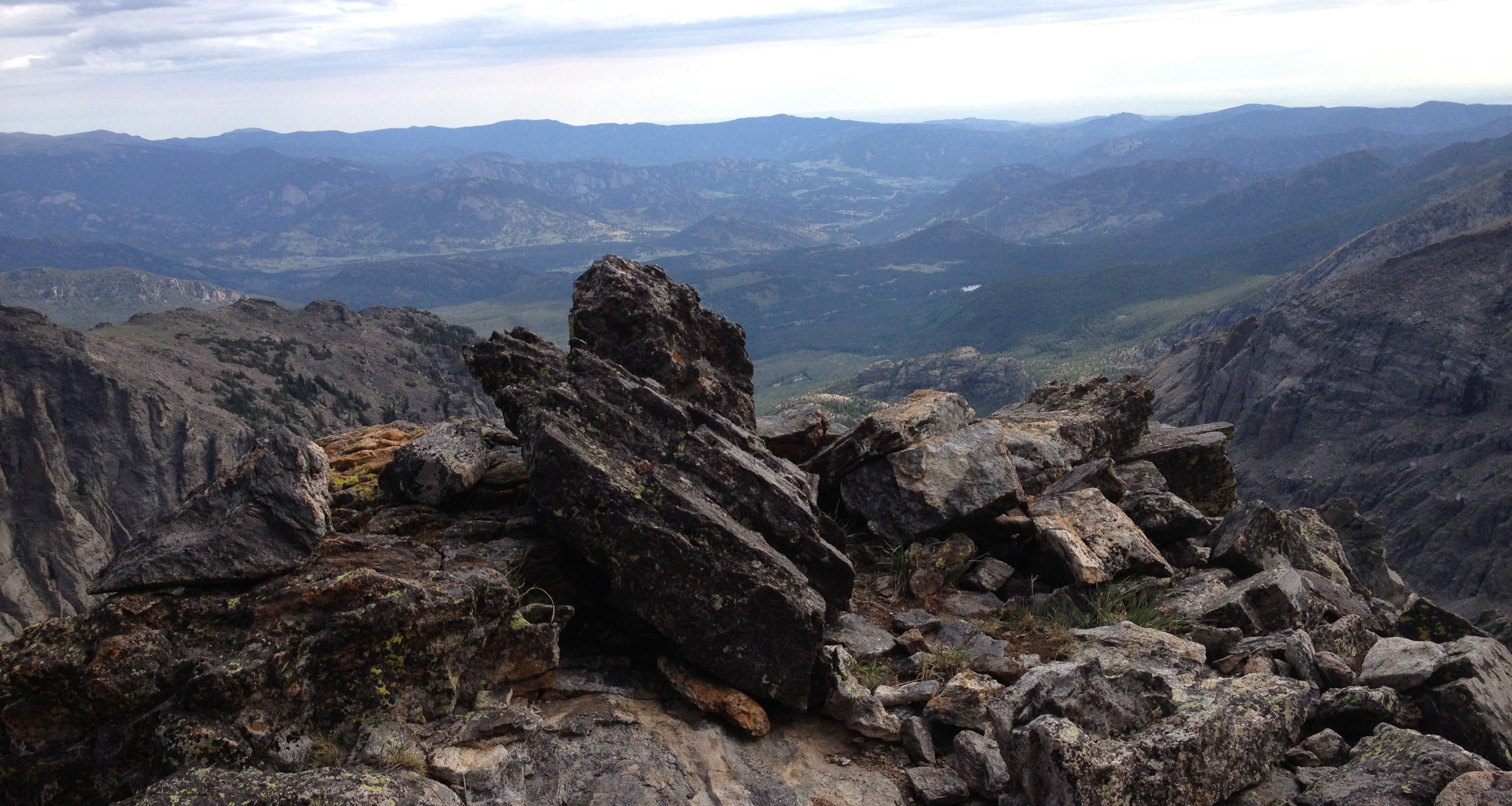
As the adrenaline started to wear off, I started to feel tired.  We sat to organize the gear, but since I had no water and only an orange to eat since dawn, a long stay wasn’t in the cards.  Topher led me down to the Cable Route area where we descended via rappel to the Chasm View area to complete a circuit begun 8 hours before.  On the way down I took a photo of some climbers that showed the steepness of the climbing.  I intended to make full use of my bragging rights.

Once we arrived at Chasm View, I insisted on some photos including posed shots before we scrambled back to The Camel to collect gear. I thanked Topher again and asked for directions to the water supply.  He pointed down to the Boulderfield and said to ‘follow my ears’ to find access to the water running beneath the big blocks of rock.  Then we parted ways.

Joe and Topher posing with The Diamond in the background. Thanks to Topher for indulging me.

The Hike Out

The lack of food and water (and altitude?) started to hit me pretty hard.  I hadn’t had any water or food aside from an orange in 9 hours, and I had only consumed 2 liters of water in the last 28 hours.  And all of this on top of gaining 14k feet in elevation in a short time, vomiting, and climbing 1000′ of hard rock. (Thankfully I was still young). After a bit of following water noises, I finally found a gap in the rocks and collected a liter of the wet stuff, which I had to put away to let the iodine pills dissolve. Using and waiting for iodine pills was another first for me; it was not the last time I’d have to suffer and wait.

Once I started hiking down the trail, I felt strangely exhilarated.  Even though I was around other people and walking on or near a well established trail, it was the first time I had ever been in the “backcountry” without other people I knew.  I felt very isolated, and I liked it. Taking in the sights, snapping photos, and watching with real interest the exploits of the local marmots, I just floated down the trail.  I felt great once more.  Everything was good.

The Casual Route and descent from Longs Peak

I followed the trail signs until I reached the trail junction for Chasm Lake. I couldn’t wait any longer for water, so I stopped and ate my last Powerbar and finished my water while admiring the spectacular views of Longs Peak. I decided it was the greatest peak in the world and that I really needed to come back someday to climb it without a guide (I did so in 1998; see The Casual Route?).

I continued down the trail and reached the Ranger Station ahead of schedule. I was going to have to wait an hour for my 6pm ride, but that was okay. Nothing could spoil my great mood, I thought.

Around 5:30pm, the weather turned ugly.  The wind picked up and rain and hail/snow started beating on me. I tried to get into the Ranger Station, but it was locked.  I put on all my clothes and huddled in the roofed map alcove to hide as well as I could. I was freezing.

And, then, my ride was late.

By 8pm, I was truly miserable.  Wet & cold with only poor shelter from the wind, I knew that my girlfriend was lost and that I was screwed. As I played out the scenarios in my head, I couldn’t see a good outcome. If she couldn’t find me in the daylight with whatever directions she had gotten, how was she going to figure it out before morning? No more light to see by and no one to ask for help; oh, I was definitely screwed.

Our route up Longs Peak (red) and my descent variation used (green)

Out of the gloom, a couple walked past me, on the way to their car.  After a polite WTF question, I explained my reasons for riding out the storm.  They offered to give me a ride to town, but I declined.  I didn’t have any place to go in Estes Park.  I needed to get to Boulder, but I couldn’t even go there without getting word to my girlfriend. And I had no way to get any word to her; I was royally screwed.

A few minutes later, as the couple drove past, they paused to make one last offer before abandoning me to the elements.  I decided I would be better served by having no where to go in Estes Park than being stuck out in the open in the middle of nowhere.  I accepted. I piled my stuff and body into the couple’s car and buckled my seatbelt, and then a pair of headlights approached.  It was my ride.

And was she pissed.  While we drove to Boulder, she explained how mad she was about having to drive all over creation, etc., etc. I said that I was sorry for her troubles, but that since I had to sit for 3 hours in wind, rain & hail I probably had the worst of it, and my vote was that we should call it even and drop it.  Uncharacteristically, she agreed.  I must have looked pretty bad.

While sitting in the car and thawing out, I wondered what my climbing buddies would think and how they’d react.  I wondered when they would decide to climb The Diamond.  But as I feared for myself, sometimes the chance to take a particular road less traveled only comes once, and an opportunity missed is an opportunity lost.

“Jump as quickly at opportunities as you do at conclusions.”

~ Benjamin Franklin

See all Trip Reports

See all Longs Peak Massif Trip Reports

The “Casual” Route?

March 31, 2009

The Diamond.

The East Face of Rocky Mountain National Park’s Longs Peak is the greatest alpine climbing wall in the Universe.   Sure, it’s just my opinion, but read on and judge for yourself.


The Diamond of Longs Peak

The Diamond of Longs Peak (photo taken 7/1/94)


When I started rock climbing some years ago, the Diamond was a place of legend:  only the climbing Greats dared challenge the gods with an attempt on the Diamond.

It requires nearly 1,000 feet of high-altitude technical rock climbing in a lightning-filled environment over wet, cold, vertical rock that cannot even begin until completing an approach of nearly 7 miles and well over 3,000′ of elevation gain.   And the easiest route up the face requires the skill and stamina to complete two pitches of 5.9-5.10a, three pitches of 5.8, and three pitches of 5.5-5.7 at nearly 14,000′ elevation.

Adding insult to this impossible dream, the easiest route is called, “The Casual Route, ” in honor of Charlie Fowler’s description of his free solo (no rope, no protection) climb of the route in 1978…he said it was “casual” in the sense of…

…not difficult, child’s play, a cinch, easily done, effortless, inconsiderable, no problem, no sweat, no trouble, nothing to it, a picnic, a piece of cake, straightforward, and undemanding.

Uh huh.  Thanks for your opinion, Mr. Fowler.  I guess that’s one for and one against, as far as voting goes.

Back in the old days, my Midwest climbing friends and I didn’t dare admit having such ambitions; we would only talk about how amazing and crazy some climbers were, and we’d keep our true feelings of envy and aspiration to ourselves. But, over the years, as I grew into a better climber and a mountaineer, I dared imagine that I, too, could climb the Diamond. Someday.

This trip report is about the effort my buddy, Brian, and I made in an effort to climb The Diamond.

Story

Having brought ourselves to thinking that we could really do it, Brian and I decided that we’d use the Spring & Summer of 1998 to prepare our skills,  fitness and confidence for a late Summer attempt.  During the 4 month preparation, we completed the following alpine snow & rock climbs to ready ourselves physically, intellectually, & emotionally:

  1. Squaretop Mountain; snowclimb (4/98)
  2. Mt Belford; snowclimb  (4/98)
  3. Mt. Princeton; snowclimb  (5/98)
  4. Mt. Harvard; snowclimb  (5/98)
  5. Mt. Tauberguache; snowclimb  (5/98)
  6. Mt. of the Holy Cross; snowclimb  (6/98)
  7. Longs Peak via Kieners; snow and rock scramble (7/98)
  8. The Saber in RMNP; 11 pitches up to 5.9 (7/98)
  9. Jackson-Johnson on Hallets Peak; 9 pitches up to 5.9 (7/98)
  10. The Love Route on Hallets Peak; 8 pitches up to 5.9 (8/98)

We had prepared very hard and felt ready to proceed.  When the weatherman predicted good weather, we set the date:  August 8, 1998.

The overall plan was:

  1. Hike in the day before to save energy for the climbing day
  2. Camp in the Boulderfield (to avoid a free solo of the 4th class plus, 320′ plus North Chimney)
  3. Descend to Broadway Ledge via the Chasm View rappels (3 150′ rappels in the pitch black darkness)
  4. Traverse the snowy ledge to the Casual Route start, skirting the opening of the North Chimney
  5. Climb the Casual Route (7 pitches plus traversing finish)
  6. If unsuccessful, escape via many rappels down the Diamond’s face, and then ascend the Camel Route to reach our campsite
  7. If successful, traverse the Table Ledge to finish the climb via Kiener’s Route
  8. Traverse to the North Face Cable Route and rappel back to Chasm View
  9. Hike back to the Boulderfield to pack up and head home

Before it was over, we’d be sleep-deprived, starved, dehydrated, exhausted, rained and hailed on, surprised, horrified, and delighted.


Brian next to his tent in the Longs Peak Boulderfield

Brian enjoying a moment of rest in the Longs Peak Boulderfield


The Hike into Camp

We started hiking in toward the Boulderfield at 9am.  We had all day to cover the distance, so we took our time.  We arrived at the Boulderfield and setup camp; and we still had hours to kill.

We wandered up to Chasm View to take in the sights, snap a few photos, and prepare ourselves to find the rappel anchors in the dark a few hours hence. All was proceeding well until we noticed the clouds building.


Joe posing with the Diamond looming in the background

Joe posing with the Diamond looming in the background


The weatherman was wrong.

One of the key problems in climbing the Diamond is the weather.  It is east facing, so any approaching weather cannot be seen until it is overhead; and with escape only possible via multiple rappels requiring one or more hours to perform, we’d have to move very fast to have any chance.  And we’d have to be lucky.

The Approach to the Climb

We arose in the dark and started for Chasm View at 4:15am.  Using headlamps, we wandered among the refrigerator-sized boulders, orienting ourselves using the faint outline of Longs against the dark sky.

Reaching the Chasm View area, our previous day efforts paid off with the quick acquisition of the Chasm View rappel anchors.  We unpacked the harnesses and the rope and made ready for a descent into a pit of darkness.

I took the first rappel.  The light from my headlamp illuminated the canyon walls, but couldn’t reach to the bottom. It was a creepy feeling to rappel into an abyss, but my lack of sleep muted any strong emotional response.


A view of the Chasm View rappel area from the start of the Casual Route; 3 150 foot rappels to descend to Broadway Ledge.

A view of the Chasm View rappel area from the start of the Casual Route; three 150 foot rappels to descend to Broadway Ledge.


My only job besides not dying was to find the next set of rappel anchors.  I only had one chance to find them as we couldn’t go back up without losing the day.

But the day started well; I found the anchor. I clipped into the bolts and then unclipped from the rope. I called out for Brian to come on down by yelling, “Off rappel!”  Brian stepped over the edge carrying our gear pack, rappelled down and clipped in next to me.  After he unclipped from the rope, I started pulling the rope down from the initial rappel anchor while he threaded it through the 2nd anchor. As we neared the end of the process, his headlamp died.

I couldn’t believe it.  After 4 months of planning, he didn’t replace the 50 cent batteries. Fortunately, it wasn’t really a big deal.  I would just have to find the next two anchors.  Although, it was possible that we’d have to wait a few minutes at the bottom of the raps for the sky to brighten enough for Brian to accomplish the traverse to the start of the climb without falling off Broadway Ledge.

I finished getting ready for the next rappel while Brian put the dead headlamp away in our gear pack.  I heard him say, “Shit!”  With some reluctance, he explained that when he unzipped the backpack, one of his rock climbing shoes fell out and disappeared into the darkness.  Now that was a big deal.  No shoe, no climb.

If the shoe fell below Broadway Ledge, all the way down to Mills Glacier, it would take us too long to recover it even if we could find it.  We’d lose the day. Brian says, “Sorry.”  I replied, “Maybe we’ll get lucky; maybe it stopped at Broadway Ledge.”  In one part of my mind, I was mad; all this effort wasted.  In another part of my mind, I was relieved that we would be going home alive.

But we had to try to find it, so we continued down into the black pit.

At the bottom of the 2nd rappel, there it was.  Brian’s shoe had stopped on a small ledge. The climb was on.

We completed the 3rd rappel and then started the traverse immediately.  The daylight had begun, and we could see without the headlamps.  And we could see that the sky was already threatening.  Top of the North Chimney was a loose, snowy, narrow, sloping trap.  We decided to do a belay while skirting the rim of the North Chimney and then found “The Ramp” about 20 feet further.  At the top of that large sloping ledge, we started the climb with the knowledge that we had to go fast.

The Climb


Joe on top of the D1 pillar, about to start the 5.9 crack of Pitch 2

Joe on top of the D1 pillar, about to start the 5.9 crack of Pitch 2


Pitch 1: Brian gave me the pack and took the first lead up a left-facing corner, and then up and left to a ledge. I followed without incident. We were delighted to see that the weather was clearing. (5.5)

Pitch 2: I took the second lead up a short easy section to the top of a pillar, and then up a tough crack to a belay stance near the start of the traverse.  My primary concern was to find the correct traverse starting point.  The correct traverse is a protectable 5.7 while the improper one is poorly protected 5.10c.  I found it right at a spot with a nice stance. Brian followed quickly behind. (5.9)

Pitch 3: Brian took the traverse.  While technically not difficult, crawling sideways is always harder than climbing up. I found it hard to find the best route over the flakes and small ledges, negotiating past wet rock, and trying to keep the gear pack from pulling me off-balance.  We belayed beneath a squeeze chimney. (5.7)


A view straight up of Brian leading the 5th pitch

A view straight up of Brian leading the 5th pitch


Pitch 4: I led the fourth pitch up a short, challenging squeeze chimney, and then up and slightly left on easier terrain to the end of “The Ramp2.”  I made sure to continue past the initial piton to give Brian enough rope for a long 5th pitch. Brian followed without incident. The weather started worsening. (5.8)

Pitch 5: Brian then led up a long dihedral and belayed at a grassy ledge.  I followed in light rain & hail.  By the time I reached the belay, the rain & hail had stopped.  We didn’t even discuss bailing. (5.9)

Pitch 6: I took a short lead to the Yellow Wall Bivy Ledge, which was a magnificent ledge for such a vertical environment.  I could see how it would be possible to sleep on the ledge quite comfortably.  Once Brian arrived, it started to hail and rain again, but this time a bit harder.  And then it stopped again.  Still no lightning, so we didn’t speak of retreating.  We took a short break to give the wind some time to dry out the technical crux of the route.

Pitch 7: The crux pitch.  If we could get up this last pitch, we would make it. But failure was still within our grasp:  if the rock got too wet or if lightning started, we’d fail and bail.  Brian took this lead and moved very quickly.  After a short time, the slack in the rope started being pulled up.  After 3 quick rope tugs, it was my turn to make it past the several hardest moves of the climb. As I started climbing, the rain & hail started again.  I continued up through the wet, narrow inset, and then started up the squeeze chimney.  I struggled to get through the chimney with the pack on; when I finally got past it, I was completely exhausted.  I took off the pack and passed it up to Brian, then I steeled myself to move past the bulge blocking my path to Table Ledge. Then it was over.

We had made it.  I needed a short break, despite the threatening weather; but we couldn’t fail now.  We had finished the Casual Route, but we still needed to escape the face and the mountain.

The Escape


Joe sitting on the far end of Table Ledge, preparing to belay Brian to complete our escape from the East Face of Longs Peak

Joe sitting on the far end of Table Ledge, preparing to belay Brian to complete our escape from the East Face of Longs Peak


We were sitting on the Table Ledge which we needed to traverse left to link up with the Kieners Route.  But the ledge had a break in it, so we had to do a descending and then ascending traverse to find our escape.  I started by traversing left past a piton, and then down and left about 25 feet to another ledge called Almost Table Ledge.  A wet downclimb is challenging in any case, but at nearly 14000 feet and after hours of climbing, it was very unnerving.  I carefully traversed left until I could climb up to the Table Ledge again and belayed off some fixed gear backed up by two cams.  Brian followed quickly, and then we continued left, walking along the ledge until we could move above the Diamond onto the north face.

As we stepped above the Diamond, we were shaken by thunder.  To minimize our exposure to the elements, we traversed directly to the Cables Route.  We were rained and hailed upon, but no close lightning strikes.

After a short hike, we rappelled down to Chasm View, where we had started the day many hours earlier.


The Diamond, with key locations and pitches referenced.  Note:  the photo is from a different trip.

The Diamond, with key locations and pitches referenced. Note: the photo is from a different trip.


The Return Home

It seemed that the entire Boulderfield camp ground was out watching our return.  I wanted to believe that it was admiration for a job well done, but there is no doubt it was pity.  We felt like and must have looked like the walking dead, as we walked back into camp.   One wonderful fellow walked


Joe eating the greatest meal of all time...using a nut tool as a replacement spoon

Joe eating the greatest meal of all time...using a nut tool as a replacement spoon


over to our bivy site with a steaming hot dinner, which we gratefully accepted since we had no food left at all.  I had only eaten 1,000 calories during the day, and Brian even less.  That Hawaiian Chicken dinner tasted better than any meal I ever had before or since, and it got us home.

Thanks, neighbor!

It had taken us 2 days to hike 15 miles and 4,000 feet of elevation gain, while climbing nearly 1,000 feet of 5th class terrain and descending 600 feet on rappel.

It was and continues to be a great feeling to  accomplish such a long held goal.

So what’s your vote?

See all Trip Reports

See all Longs Peak Massif Trip Reports

The Great Cirque: Meeker to Longs traverse

March 10, 2009

The idea for the Mt. Meeker to Long’s Peak traverse came to me last December after climbing Mt. Meeker on a clear, cool morning.  Sitting on the Meeker summit rock, I looked over the Loft to Longs Peak and saw the potential for a beautiful traverse.  At that moment, I decided I would come back to bag the two-summit traverse.  The idea eventually grew into a quest to bag “Colorado’s greatest mountain cirque” (Roach).

Of course it is a long bit of hiking, but there is also a short technical obstacle to overcome:  Mt Meeker and Longs Peak are separated by “The Notch”.  The Notch is a gap in the rock approximately 75′ deep at the ridgeline and which continues as a deep and steep gully down each side of the mountain.

Nevertheless, where there’s a will . . .


The Great Circ Route

The Great Circ Route


Brian and I were recovering from a full summer of rock climbing and related injuries, so I was able to convince Brian to do an alpine hike.  To do the entire cirque, we chose to start the loop at the Longs Peak  cut-off to Chasm Lake, which we would take toward the Mt. Meeker East Ridge, and after summiting on Meeker and then Longs, we’d return via the Boulderfield (about a 5 mile loop).

In total, the Great Cirque trek would take approximately 12 hours including the hike from and to the parking lot and would cover approximately 15 miles and an elevation gain of approximately 5700′.

Our plan had eight steps:

  1. Hike from Longs Ranger station toward Longs to Chasm Lake cutoff
  2. Hike past Chasm Lake and up through Iron Gates (class 2) approach to Mt. Meeker East Ridge
  3. Traverse Mt. Meeker ridge (class 3) to summit
  4. Descend to Loft & hike (class 2) to high point on Loft north side
  5. Descend Gorrells Traverse route (4th Class crack system) to Notch gully and ascend to Notch high point (class 4), and then climb to Longs ridge and summit using the 5th class rock finish to the Notch Coulior route
  6. Descend Longs North face via Cables route (two single rope rappels) to Chasm View
  7. Hike to Boulder Field
  8. Hike around Lady Mount Washington to complete circuit at Chasm Lake cutoff

Alternatives to avoid carrying ropes and difficult scrambling:

  1. Take Clark’s Arrow from Loft to join Keyhole route – avoid 4th class chimney and technical pitch
  2. Take Keyhole route from Long’s summit back to Boulderfield – avoid rappels

Time table:

  • Start hiking – 4am
  • Reach bottom of Iron Gates – 7am (first light)
  • Mt. Meeker summit – 9am
  • Long’s Peak summit – Noon
  • Reach car – 4pm

Report

Brian picked me up at 3am.  I was ready to go when he arrived, for a change, and we immediately headed out of Boulder for Lyons, and then the Long’s Peak Ranger Station parking lot.  We arrived just before 4am to find a parking space right in front.  A good omen.  The cold weather a week earlier must have suspended the weekend cattle drive for Longs Peak.

We powered up the trail needing only long underwear to stay warm despite the high winds and temperatures in the 30’s.  Around 5:30, still an hour or so before dawn, we reached a popular rest stop, the fork to Chasm Lake (left) or the Boulderfield (right).  The frigid winds eliminated any thought of a rest and we hurried onward toward  Chasm Lake to find some shelter.  We found a suitable rock formation approximately 300 yards further where we could stop to put on fleece and wind jackets.  My numb fingers made me regret leaving my regular gloves at home, and I would later find another reason to regret bringing only fingerless gloves.

The trail from the Ranger Hut below the Ship’s Prow (rock formation which separates the canyons below Mt. Meeker to the left and Long’s Peak & Chasm Lake to the right) to the Iron Gates is indistinct and generally over talus.  We knew the Iron Gates gully ran up the left of the buttress which is to the left of Cathedral Buttress (the awe inspiring buttress which runs down from the Mt. Meeker summit to the canyon floor), but of course this is difficult to see in the twilight.  Fortunately, a moment of hesitation allowed the sunrise to show us the path.

The Iron Gates gully proved to be a wonderful route to the Mt. Meeker East Ridge.  At the top of the 2nd class gully, a short 3rd class scramble brought us to the ridge and the endless vistas of the Eastern and Southern horizons. More importantly, an eastern view brought us exposure to the sun on a cold windy morning.

We paused to enjoy the radiation, eat a quick snack and apply sunscreen. After a few minutes, we continued on our quest.  This leg of the cirque led us west up the ridge toward the Mt. Meeker summit.  The easiest path was the ridgeline itself, which slopes about 20 degrees to the south (left) and 90 degrees to the north (right).  With the wind gusting up to 40 mph, we took care to avoid becoming a cliff diver and wasting all our efforts.


Our route from Meeker

Our route from Meeker


In a couple places, the traverse exhibited a common 4th class difficulty: it was 5th class without good route finding instincts.  We reached the summit at 9am with increased respect for the smaller sister of the mighty Longs Peak.  The summit itself is an unlikely square block sitting about 4 feet higher than the surrounding rock.  Underneath the block is an alcove that provided shelter from the wind and a nice spot for another snack.


The approach to and descent into the hidden Notch (dotted portion), then the ascent to the summit

The approach to and descent into the hidden Notch (dotted portion), then the ascent to the summit


We continued the traverse across the ridge and then down to the Loft, following the natural line.  In order to find Gorrells Traverse route on the far side of the Loft, we angled toward the high point (North end) of the Loft that forms one side of the Notch.  The Notch separates the Loft from Long’s Peak and prevents the easy hike to Long’s summit.

Gorrells Traverse route is a 4th class crack system  that descends into the Notch gully, SW side.

Per Rossiter’s guide book, RMNP: The High Peaks:

Hike NW to the highpoint of the SE ridge above The Notch. Descend to the west and locate cairns that mark the tops of two chimneys.  Downclimb the north chimney for about 200 feet to a broken platform that is about 100 feet above the gully leading up to The Notch.  Rappel into the gully from the north end of the platform or traverse up and left toward The Notch until it is possible to scramble down into the gully.


Gorrells Traverse

Gorrells Traverse. Photo from a later trip.


As in all guide book ratings, the rating is right if your technique and route finding is up to snuff.  There is also well-used rappel anchor for the unsure. We jammed down the cracks:  blind feet and bomber hands.   I got a tear in my wind jacket for the effort.  At the bottom of the first downclimb, we traversed right and slightly uphill to reach another gully which we downclimbed.  It was quite exposed but went rather easily as well.  From the bottom of the downclimb, we turned right and scrambled up to reach the top of the Notch.


Our route from the Notch to Longs Peak summit

Our route from the Notch to Longs Peak summit. Photo from earlier trip.


From the top of the Notch, we could see down the Notch Couloir toward the Broadway Ledge.  We also speculated on the feasibility of a tyrrolian traverse across the Notch without conclusion.  Since the rock was still non-technical at that point, we continued scrambling and moved out of the Notch toward the summit ridge.  We got to within 90 feet of the ridge before we ran out of scrambling terrain.

Since we brought rock gear, we didn’t feel compelled to stay with the Notch Couloir route (rated 5.2); in fact, we specifically wanted to find something more interesting…more memorable.  Brian spotted a rappel anchor at the top of the Long’s side of the Notch, approximately 90 feet above us; we agreed to climb toward it over the moderate looking moves.


A view of the technical climb to reach the summit ridge

A view of the technical climb to reach the summit ridge


We roped up and Brian took off for the ridge, his hiking boots scraping on clean 5.5  rock.  Our “mini-rack” of climbing gear was sparse enough to fit in a coat pocket, but it turned out to be ideal for a short pitch at 14,000 ft. elevation.   Near the top, Brian decided to pull a roof directly above rather than take the obvious ramp to the left.  When I questioned his intentions (with a yell from below), he explained, “you’ll thank me.”  Later, after pulling over the top on monstrous buckets, I did.

All that was left was the short but interesting ridge scramble and then a walk to the summit marker, which we reached at 11:54am.  We rested in luxurious bivy site and congratulated ourselves for a great trek.  It was, after all, quite literally all downhill from there.


Our descent route to the Boulderfield

Our descent route to the Boulderfield. Photo from later trip.


The descent through the Cable Route was interesting as a result of snow and ice adding frictionless treachery to the loose rocks in our path.  I lost my concentration on a relatively flat section and slipped on the ice.  My fall on the rock sheared off the front half of my right thumbnail.  This shockingly painful and bloody injury would cause me considerable grief during the rappels to come.  We scrambled down to the lower rappel anchors and made it to the Boulderfield in good time.

The hike out of the Boulderfield is always a death march, but this time I felt so good about the climb that I didn’t mind it at all. We reached the car at 4pm and drove into Lyons for some Mexican food.

It was all good, I just shouldn’t have ordered fajitas. They’re too hard to roll with just one hand!

See all trip reports

Longs Peak: Keyhole Ridge

December 3, 2008

Story

With a long break coming up, Brian and I looked for a long, high-altitude climb to keep us sore for a few extra days.  We settled on Longs Peak Keyhole Ridge: a moderate ridge climb with spectacular views and a direct route to the summit.  I also had a private agenda; I was going to see if I could avoid dehydration rather than tolerate it.

The route included a 7.25 mile one-way hike with a 3,600 foot elevation gain (ranger station to false keyhole) plus 5 mostly adventurous pitches of 4th class to 5.5 climbing. We thought we’d start early despite a perfect Summer weather forecast.

keyholeridgeroute3

We arrived at the full parking lot just before 4am and started out under a clear sky and bright moon right at 4am. Brian and I are still fairly fast hikers, even with a pack full of metal and rope; we reached the first bridge (just before tree line) in 45 minutes, which is a good a speed as we’ve done. We reached the cut-off to Jim’s Grove around 5am and the Boulder Field corral after 2.5 hours. With no small amount of pleasure, we noted that 2.5 hours to the Boulder Field is as fast as we’ve ever done.

We took a short break to enjoy a snack, tank up on water, stash some gear, and be amazed by the crush of people milling around the center of the Boulder Field. Rested and me with a full belly (a bar and 1 ½ liters of water), we started hiking toward the Keyhole. Just before the Keyhole is a NW-facing ramp that leads to the False Keyhole further up the NW Ridge of Longs Peak. From the False Keyhole (between the 1st & 2nd towers along the NW Ridge), we were able to mount the ridge and begin climbing toward the peak with the following pitches / sections of climbing:

  1. 4th Class Scramble: to reach the initial climbing section, we scrambled up along the ridge line for about 50 feet.
  2. Ridge Tiptoe & Climb to Second Tower: a scary, exposed section of blocks create a 4th class scramble along a 3 foot wide staircase with hundred foot drops to either side; we roped up. This scramble leads to the foot of the 2nd tower. From the foot of the tower, we traversed left (5.2) to reach a steep ramp that leads to the top of the tower. The ramp (5.4) led up to a number of options to reach the top of the tower; we went left to a ledge and then up to the top of the tower (5.5).
  3. Downclimb and Ledge Traverse: From the top of the 2nd tower, we descended to the west side of the ridge, down climbing 10 feet to a ledge.
    Longs Peak Keyhole Ridge Tower

    Longs Peak Keyhole Ridge Tower

    The ledge led to a low point between the 2nd tower and the remaining NW Ridge.

  4. Scramble to top of ramp: From the saddle, we moved up a broad, low angle ramp to reach a cliff below the NW Ridge. At the end of this pitch, I had a beautiful sit-on-the-cliff-edge, feet dangling belay overlooking the Boulder Field.
  5. Face Climb to Ridge Top: Finally, we climbed the cliff to get back to the top of the ridge (5.5)
  6. Scramble & Hike to Summit: We unroped and climbed along the ridge crest. Near the end of the ridge, we dropped down 10 feet to the left to pass the last tower (3rd class). We then scrambled to the summit level. Once we reached the summit block, we had a 100 yard hike to the summit and the masses milling and lounging around like on Miami Beach.

keyholeridgeroute

On the summit at noon was right on schedule. We rested and I ate a bite of lunch while finishing my 2nd liter of water since the Boulder Field.

After our short break, we descended the Cables Route down the north face without incident.

keyholeridgeroute2
Once we reached the corral and our stash, we refilled bottles and bellies with water.

As we left the Boulder Field, my toes were already feeling the beginnings of “Fire Toes” syndrome, a very painful friction condition brought on by my newish Makalus. I’ve found that the newer style boots with rubber rands covering the toes will not break in; they insist on breaking in your feet.

The hike out of the Boulder Field and through Jim’s Grove was long and hot, but went without any ankle turns. We took a short break after the bridge that reconnects with the main trail, where I finished my 7th liter of water for the day.

Trudge, trudge, trudge. It is always the same death march back to the car after a Longs Peak summit. The only sign of aging I can discern is a strong preference for going uphill in the morning; the downhill return is always a dread. My toes felt horribly abused.

Still, the time passed relatively quickly due to our use of “Movie Quiz”: a game of guessing movie sources for quotes or naming movies that a particular actor was in. We reached the car at 4pm, where I was pleasantly surprised to find that, once again, the toes were still attached.

And, aside from boot tortures, I felt great, thanks to my water guzzling efforts.

Route Map: Yellow is standard Keyhole route. Our variations are in red.

14.5 miles, ~4,850 ft elevation gain, 12 hours; not bad for two old guys

14.5 miles, ~4,850 ft elevation gain, 12 hours; not bad for two old guys

Complications

  • None

Mistakes

  • None

How I Got Lucky

  • The weather was great all day
  • I was able to find a lot of water on the trail to avoid dehydration without carrying more than 2 liters at a time

Return to PeakMind blog


%d bloggers like this: